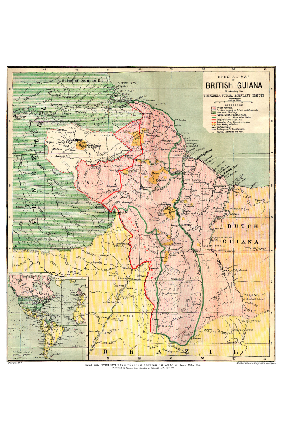
Dispossesions in the Americas

Dispossesions in the Americas

  • Lar
  • Explorar
  • Autores
  • Sobre
  • Arte
  • Corpos
  • Currículos
  • Patrimônio Cultural
  • Mapas
  • Territórios
Voltar à seção Explorar

Lendo em Inglês

Mapa 1898

SPECIAL MAP OF BRITISH GUIANA Illustrating the VENEZUELA-GUIANA BOUNDARY DISPUTE

    Publicado: 1898

    • Baixar Imagens
    • Baixar Imagens

    Lendo em Espanhola

    Mapa 1898

    SPECIAL MAP OF BRITISH GUIANA Illustrating the VENEZUELA-GUIANA BOUNDARY DISPUTE

      Publicado: 1898

      • Baixar Imagens
      • Baixar Imagens
      Mapa 1898

      SPECIAL MAP OF BRITISH GUIANA Illustrating the VENEZUELA-GUIANA BOUNDARY DISPUTE

        Publicado: 1898

        • Baixar Imagens

        Povos

        • ARAWAK
        • GUARUANA
        • GUAICAS
        • WARAO
        • ARNACOTO
        • MAKU
        • WAIKAS
        • MUCUCHIES
        • WAPISHANA
        • ARAWAKEN
        • KARIBENG
        • DRIO
        • ATORAI
        • TARUMAS
        • PIANOGHOTTOS
        • CARIGUANOS
        • SIRICUMES

        Citation

        Special Map of British Guiana Illustrating the Venezuela-Guiana Boundary Dispute. Map. London & Liverpool: George Philip & Son;1898. Accessed March 4;2023. https://www.elibron.com/wp-content/uploads/745/map_1.pdf.

        • Baixar Imagens

        Itens Relacionados

        Sketch of the country from reduction to Buenos Ayres, shewing the movements of B. Genl. Beresford, when he captured that place June 1806. Drawn from memorandums furnished by Capt: Donnelly

        Sketch of the country from reduction to Buenos Ayres, shewing the movements of B. Genl. Beresford, when he captured that place June 1806. Drawn from memorandums furnished by Capt: Donnelly

        Mapa 1806
        States in Guatemala and el Salvador on the Eve of Spanish Conquest.

        States in Guatemala and el Salvador on the Eve of Spanish Conquest.

        Mapa 1524
        Seropositivo [Livro de Visitas] [Soropositivo]

        Seropositivo [Livro de Visitas] [Soropositivo]

        Obra de arte
        De cuando el río dejó de ser río para convertirse en otra cosa [Quando o rio deixou de ser rio para se transformar em outra coisa]

        De cuando el río dejó de ser río para convertirse en otra cosa [Quando o rio deixou de ser rio para se transformar em outra coisa]

        Obra de arte
        TITLED INDIGENOUS TERRITORIES (TIOCs) IN THE BOLIVIAN HIGH PLATEAU by 2011

        TITLED INDIGENOUS TERRITORIES (TIOCs) IN THE BOLIVIAN HIGH PLATEAU by 2011

        Mapa 2011
        Cover-up of the Christopher Columbus statue behind the Bayfront Park Amphitheater in Miami, Florida [Cobrimento da estátua de Cristóvão Colombo atrás do Anfiteatro Bayfront Park, em Miami, Flórida]

        Cover-up of the Christopher Columbus statue behind the Bayfront Park Amphitheater in Miami, Florida [Cobrimento da estátua de Cristóvão Colombo atrás do Anfiteatro Bayfront Park, em Miami, Flórida]

        Obra de arte
        Mapa Nacional de Pueblos Indígenas y Afrodescendientes

        Mapa Nacional de Pueblos Indígenas y Afrodescendientes

        Mapa 2016
        Victoria regia [Vitória-régia]

        Victoria regia [Vitória-régia]

        Obra de arte

        Desapropriações nas Américas

        Um projeto de

        University of Pennsylvania

        Copyright 2024

        Com o apoio de

        Mellon Foundation

        Projeto e desenvolvimento do site

        Element 84

        Créditos da arte

        Special Map of British Guiana Illustrating the Venezuela-Guiana Boundary Dispute. Map. London & Liverpool: George Philip & Son;1898. Accessed March 4;2023. https://www.elibron.com/wp-content/uploads/745/map_1.pdf.

        Páginas do site

        • Lar
        • Explorar
        • Autores
        • Sobre
        • Arte
        • Corpos
        • Currículos
        • Patrimônio Cultural
        • Mapas
        • Territórios