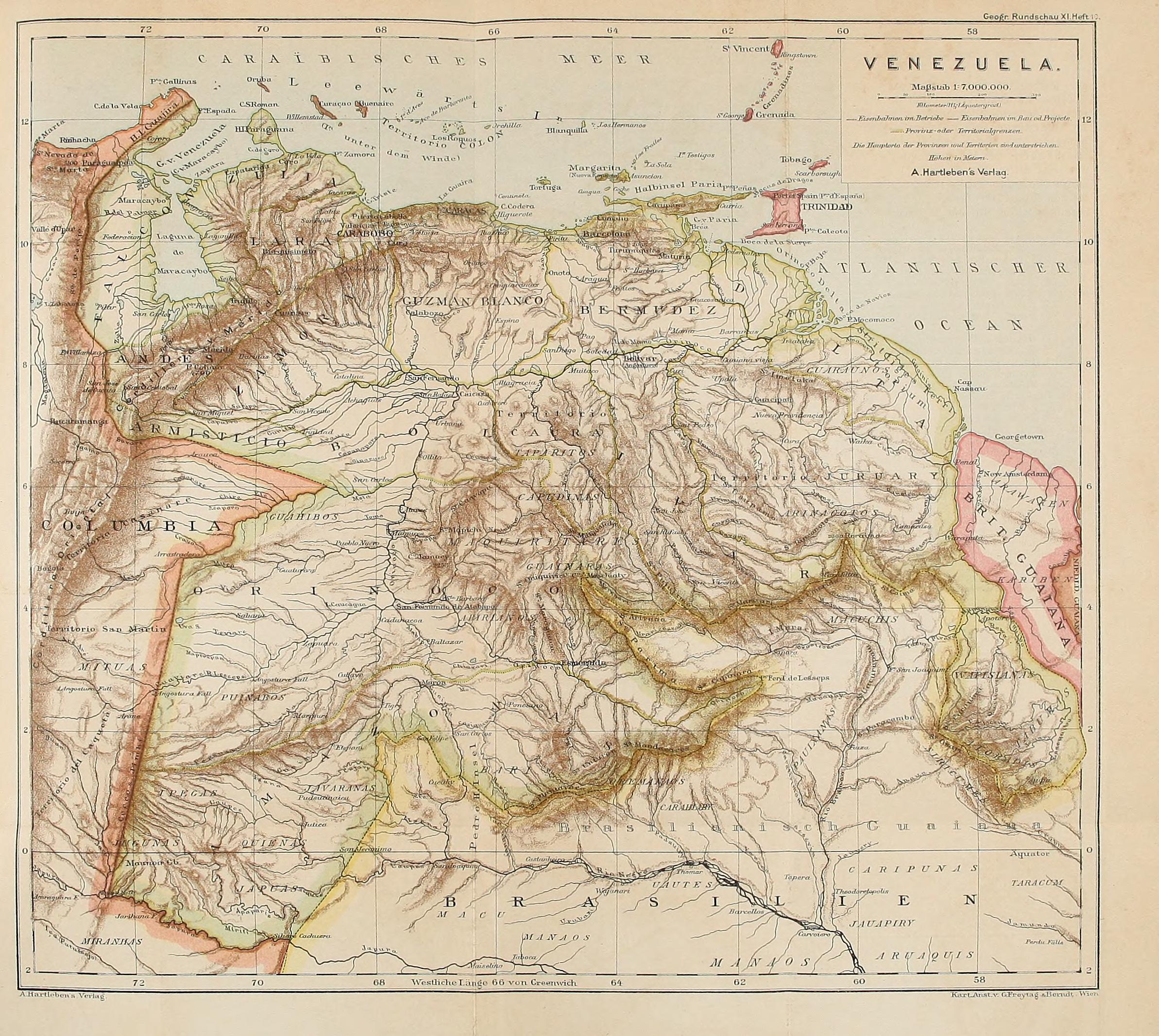
Dispossesions in the Americas

Dispossesions in the Americas

  • Lar
  • Explorar
  • Autores
  • Sobre
  • Arte
  • Corpos
  • Currículos
  • Patrimônio Cultural
  • Mapas
  • Territórios
Voltar à seção Explorar

Lendo em Inglês

Mapa 1878

VENEZUELA

    Publicado: 1878

    • Baixar Imagem
    • Baixar Imagem

    Lendo em Espanhol

    Mapa 1878

    VENEZUELA

      Publicado: 1878

      • Baixar Imagem
      • Baixar Imagem
      Mapa 1878

      VENEZUELA

        Publicado: 1878

        • Baixar Imagem

        Povos

        • GUARUANA
        • TAPARITAS
        • JIVI
        • CADUPINAPOS
        • YEKUANA
        • GUAINARES
        • ARNACOTO
        • ARAWAK
        • CARIBE
        • WAPISHANA
        • MUCUCHIES
        • ABERIANA
        • PUINAVE
        • JAVARANAS
        • BARI
        • MAKU
        • JAPUAS
        • JUGUNAS
        • YPECAS
        • QUIENAS
        • MAJANAO
        • PAUICANAS
        • CARAHIABY
        • OREMANAOS
        • JAUAPIRY
        • MITUAS
        • TABURAS
        • SIRIEUMES
        • ATORADIS
        • TABUMAS
        • TARACUM
        • CARIPUNAS
        • UAUTES
        • MIRANHAS

        Citação

        "Venezuela." Map. In Deutsche Rundschau für Geographie;edited by Friedrich Umlauft;459. Vol. 11. Wien A. Hartleben;1878. Accessed February 11;2023. https://archive.org/details/deutscherundscha11wien/page/458/mode/2up.

        • Baixar Imagem

        Itens Relacionados

        LA GRAN CIVDAD I CAVEsa y corte rreal de los doze rreys Yngas, Santiago del Cuzco en medio del rreyno y obispado

        LA GRAN CIVDAD I CAVEsa y corte rreal de los doze rreys Yngas, Santiago del Cuzco en medio del rreyno y obispado

        Mapa 1615
        Posibles líneas migratorias de los grupos Arawuacos con cerámica modelada y pintada portadores de sistemas
agrícolas y del modo de vida aldeano igualitario. Siglo III Antes de Cristo.

        Posibles líneas migratorias de los grupos Arawuacos con cerámica modelada y pintada portadores de sistemas agrícolas y del modo de vida aldeano igualitario. Siglo III Antes de Cristo.

        Mapa -400 - -100
        SÜD-AMERIKA, BL. 4

        SÜD-AMERIKA, BL. 4

        Mapa 1911
        MAPPA DO BRAZIL baseado no mappa da America do Sul de Stieler

        MAPPA DO BRAZIL baseado no mappa da America do Sul de Stieler

        Mapa 1900 - 1999
        Chili

        Chili

        Mapa 1663
        A Map of the Provinces Paraguay and Tucuman with the
     River Plate

        A Map of the Provinces Paraguay and Tucuman with the River Plate

        Mapa 1698
        Present Distribution of the Otomi Family

        Present Distribution of the Otomi Family

        Mapa 1969
        CARTE que représente la Partie Méridionale DU BRÉSIL ET DU PEROU;LE CHILI SEPTENTRIONAL;EL LE PARAGUAY;Ce qui fait la Pártie de milieu DE L’AMÉRIQUE MERIDIONALE PAR LE SR. D’ANVILLE À VENISE Par P. Santini 1779. Chez M’.Remondiri.

        CARTE que représente la Partie Méridionale DU BRÉSIL ET DU PEROU;LE CHILI SEPTENTRIONAL;EL LE PARAGUAY;Ce qui fait la Pártie de milieu DE L’AMÉRIQUE MERIDIONALE PAR LE SR. D’ANVILLE À VENISE Par P. Santini 1779. Chez M’.Remondiri.

        Mapa 1779

        Despossessões nas Américas

        Um projeto de

        University of Pennsylvania

        Copyright 2024

        Com o apoio de

        Mellon Foundation

        Projeto e desenvolvimento do site

        Element 84

        Créditos da arte

        “Venezuela.” Map. In Deutsche Rundschau für Geographie;edited by Friedrich Umlauft;459. Vol. 11. Wien A. Hartleben;1878. Accessed February 11;2023. https://archive.org/details/deutscherundscha11wien/page/458/mode/2up.

        Páginas do site

        • Lar
        • Explorar
        • Autores
        • Sobre
        • Arte
        • Corpos
        • Currículos
        • Patrimônio Cultural
        • Mapas
        • Territórios