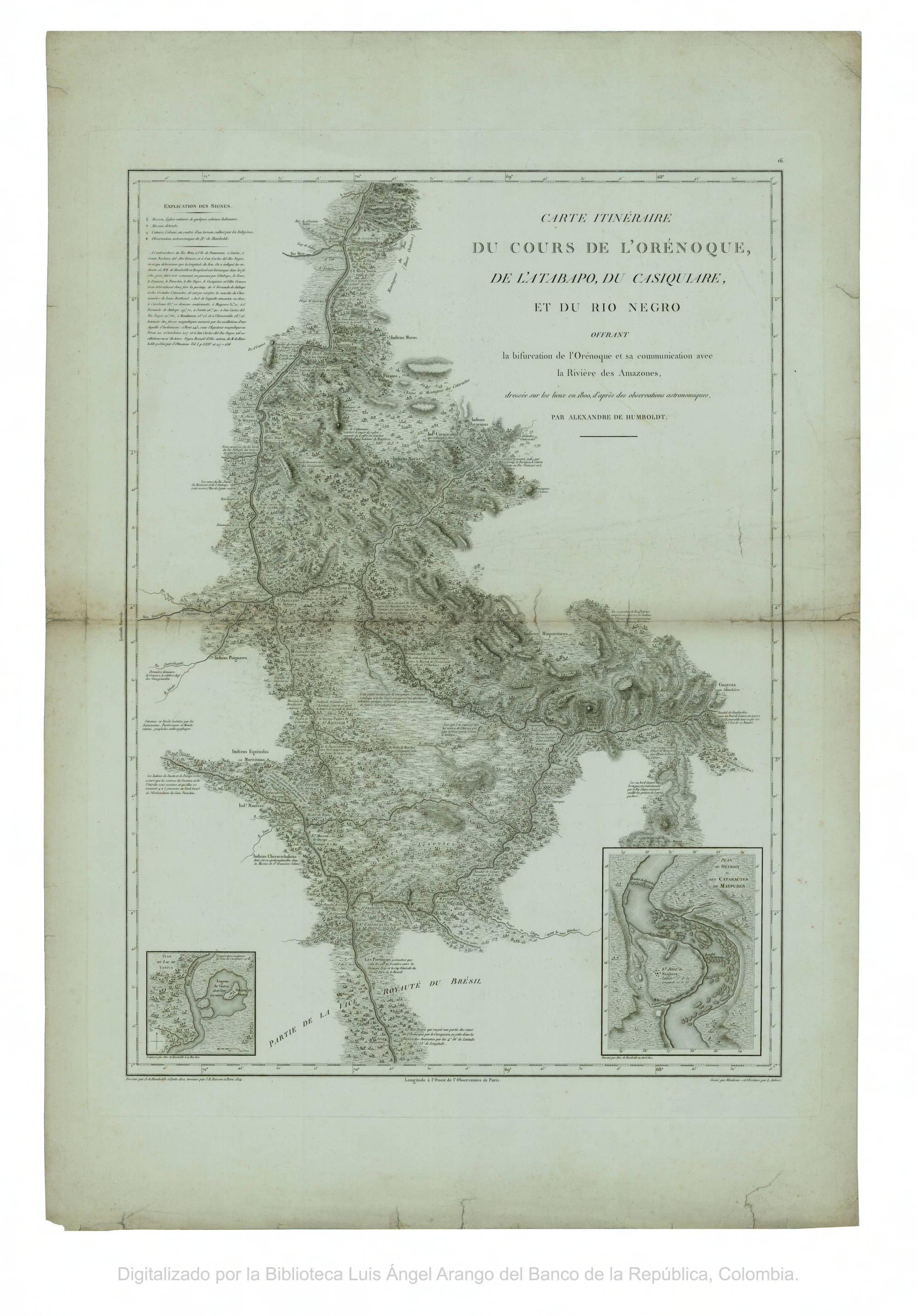
Dispossesions in the Americas

Dispossesions in the Americas

  • Lar
  • Explorar
  • Autores
  • Sobre
  • Arte
  • Corpos
  • Currículos
  • Patrimônio Cultural
  • Mapas
  • Territórios
Voltar à seção Explorar

Lendo em Inglês

Mapa 1802

CARTE ITINÉRAIRE DU COURS DE L’ORÉNOQUE;DE L’ATABAPO;DU CASIQUIARE;ET DU RIO NEGRO OFFRANT la bifurcation de l’Orénoque et sa communication avec la Rivière des Amazones

  • HUMBOLDT;ALEXANDER VON;ET AL.

Publicado: 1814

  • Baixar Imagens
  • Baixar Imagens

Lendo em Espanhola

Mapa 1802

CARTE ITINÉRAIRE DU COURS DE L’ORÉNOQUE;DE L’ATABAPO;DU CASIQUIARE;ET DU RIO NEGRO OFFRANT la bifurcation de l’Orénoque et sa communication avec la Rivière des Amazones

  • HUMBOLDT;ALEXANDER VON;ET AL.

Publicado: 1814

  • Baixar Imagens
  • Baixar Imagens
Mapa 1802

CARTE ITINÉRAIRE DU COURS DE L’ORÉNOQUE;DE L’ATABAPO;DU CASIQUIARE;ET DU RIO NEGRO OFFRANT la bifurcation de l’Orénoque et sa communication avec la Rivière des Amazones

  • HUMBOLDT;ALEXANDER VON;ET AL.

Publicado: 1814

  • Baixar Imagens

Povos

  • YARURO
  • OTOMACO
  • MACOS
  • JIVI
  • PUINAVE
  • EQUINABIS
  • MANIVAS
  • CHURUVICHAGENA
  • PIAROA
  • CURACHICANAS
  • YAVARANA
  • CARIBE
  • YEKUANA
  • GUAINARES
  • ABERIANA
  • GUAICAS
  • GUAHARIBOS

Citation

Humboldt;Alexander von;and Aimé Jacques Alexandre Bonpland. Carte itineraire du cours de l'Orenoque;de l'Atabapo;de Casiquiare et du Rio Negro;offrant la bifurcation de l'Orenoque et sa communication avec la rivière de l'Amazone. Map. Paris: J.B. Porison;1814. Accessed February 2;2023. https://babel.banrepcultural.org/digital/collection/p17054coll13/id/653/rec/75.

  • Baixar Imagens

Itens Relacionados

Tierras indígenas del Darién

Tierras indígenas del Darién

Mapa 2000
"Mapa del partido de Moniquirá hasta el alto del Mercado."

"Mapa del partido de Moniquirá hasta el alto del Mercado."

Mapa 1796
Mbyá

Mbyá

Mapa 2001
Sitio de estudio

Sitio de estudio

Mapa 2010 - 2014
PUEBLO ZOQUE

PUEBLO ZOQUE

Mapa 2020
Côtes du continent d'Amérique despuis le cap Ste Marthe...jusqu'au cap Cameron.

Côtes du continent d'Amérique despuis le cap Ste Marthe...jusqu'au cap Cameron.

Mapa 1784
Map of Sonora, Showing Historic Location of Pima Bajo, Opata, Papago, and Seri Indians in 1960

Map of Sonora, Showing Historic Location of Pima Bajo, Opata, Papago, and Seri Indians in 1960

Mapa 1960
OAXACA

OAXACA

Mapa 2015

Desapropriações nas Américas

Um projeto de

University of Pennsylvania

Copyright 2024

Com o apoio de

Mellon Foundation

Projeto e desenvolvimento do site

Element 84

Créditos da arte

Humboldt;Alexander von;and Aimé Jacques Alexandre Bonpland. Carte itineraire du cours de l’Orenoque;de l’Atabapo;de Casiquiare et du Rio Negro;offrant la bifurcation de l’Orenoque et sa communication avec la rivière de l’Amazone. Map. Paris: J.B. Porison;1814. Accessed February 2;2023. https://babel.banrepcultural.org/digital/collection/p17054coll13/id/653/rec/75.

Páginas do site

  • Lar
  • Explorar
  • Autores
  • Sobre
  • Arte
  • Corpos
  • Currículos
  • Patrimônio Cultural
  • Mapas
  • Territórios