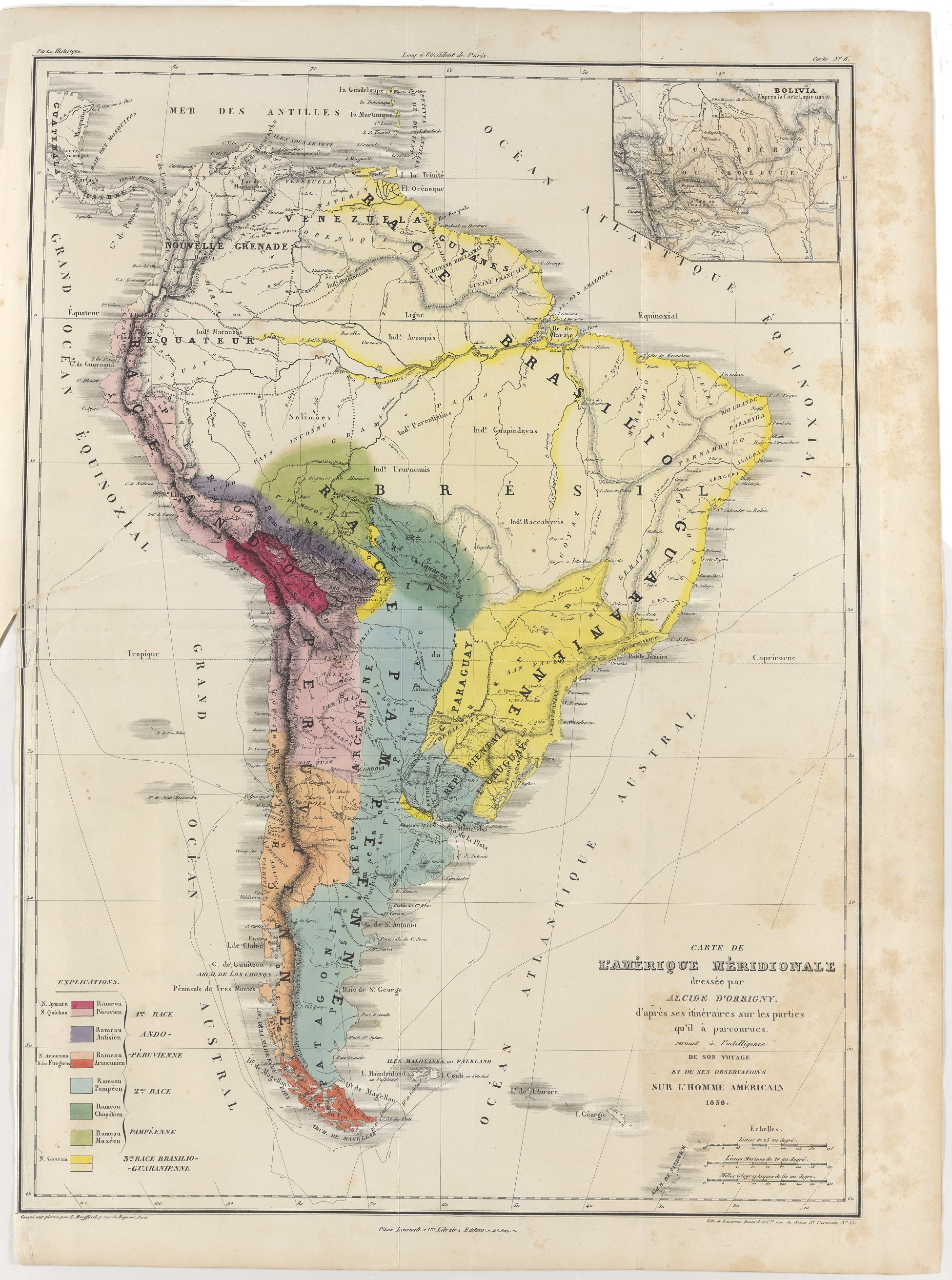
Dispossesions in the Americas

Dispossesions in the Americas

  • Lar
  • Explorar
  • Autores
  • Sobre
  • Arte
  • Corpos
  • Currículos
  • Patrimônio Cultural
  • Mapas
  • Territórios
Voltar à seção Explorar

Lendo em Inglês

Mapa 1630

Peru

  • Willem Janszoon Blaeu

Publicado: 1630

  • Baixar Imagem
  • Baixar Imagem

Lendo em Espanhol

Mapa 1630

Peru

  • Willem Janszoon Blaeu

Publicado: 1630

  • Baixar Imagem
  • Baixar Imagem
Mapa 1630

Peru

  • Willem Janszoon Blaeu

Publicado: 1630

  • Baixar Imagem

Povos

  • ATACAMA
  • ATAVILLOS
  • AYMARAES
  • CANAS
  • CANCHES
  • CARAQUES
  • CAVINASCHERIABONAS
  • CHICHAS
  • COLLA
  • CONCHUCOS
  • LUCANES
  • PALTAS
  • PASTOS
  • QUILLACINGAS
  • QUIXOS
  • SORAS
  • TACANA
  • VILCABAMBA

Citação

Blaeu, W. J. (Cartographer). (1630). Peru [Map]. Atlantis Appendix, sive pars Altera, continens Tab: Geographicas diversarum Orbis regionum, nunc primum editas. Amsterdami, Apud Guiljelmum Blaeuw. David Rumsey. https://www.davidrumsey.com/luna/servlet/detail/RUMSEY~8~1~286003~90058521

  • Baixar Imagem

Itens Relacionados

Carte de l'Amérique Méridionale dressée par Alcide d'Orbigny. d'aprés ses itinéraires sur les parties qu'il à
parcourues servant à l'intelligence de son voyage et de ses observations sur l'homme américain

Carte de l'Amérique Méridionale dressée par Alcide d'Orbigny. d'aprés ses itinéraires sur les parties qu'il à parcourues servant à l'intelligence de son voyage et de ses observations sur l'homme américain

Mapa 1829
REGIÓN PUREPECHA

REGIÓN PUREPECHA

Mapa 2000
Población o'ob (pima) en 2010

Población o'ob (pima) en 2010

Mapa 2010
RELACIÓN GEOGRÁFICA DE SANTIAGO TEJUPAN

RELACIÓN GEOGRÁFICA DE SANTIAGO TEJUPAN

Mapa 1500 - 1599
Carte de la Guyane française

Carte de la Guyane française

Mapa 1852
Indiens des Guyanes

Indiens des Guyanes

Mapa 1894
Map of Guatemala/to illustrate/Mr. A.P Maudslay's Paper

Map of Guatemala/to illustrate/Mr. A.P Maudslay's Paper

Mapa 1883
SOUTH AMERICA SHEET I. ECUADOR;GRANADA;VENEZUELA;AND PARTS OF BRAZIL AND GUAYANA

SOUTH AMERICA SHEET I. ECUADOR;GRANADA;VENEZUELA;AND PARTS OF BRAZIL AND GUAYANA

Mapa 1842

Despossessões nas Américas

Um projeto de

University of Pennsylvania

Copyright 2024

Com o apoio de

Mellon Foundation

Projeto e desenvolvimento do site

Element 84

Créditos da arte

Blaeu, W. J. (Cartographer). (1630). Peru [Map]. Atlantis Appendix, sive pars Altera, continens Tab: Geographicas diversarum Orbis regionum, nunc primum editas. Amsterdami, Apud Guiljelmum Blaeuw. David Rumsey. https://www.davidrumsey.com/luna/servlet/detail/RUMSEY~8~1~286003~90058521

Páginas do site

  • Lar
  • Explorar
  • Autores
  • Sobre
  • Arte
  • Corpos
  • Currículos
  • Patrimônio Cultural
  • Mapas
  • Territórios