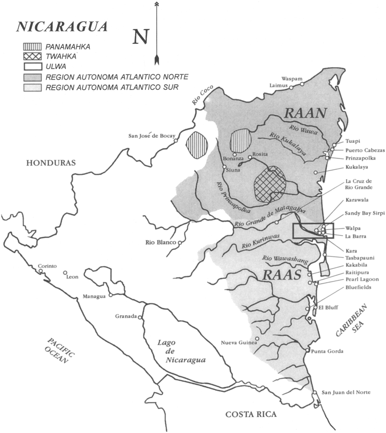
Dispossesions in the Americas

Dispossesions in the Americas

  • Lar
  • Explorar
  • Autores
  • Sobre
  • Arte
  • Corpos
  • Currículos
  • Patrimônio Cultural
  • Mapas
  • Territórios
Voltar à seção Explorar

Lendo em Inglês

Mapa 1990

Map of Nicaragua showing Ulwa settlements in Eastern Nicaragua and field study sites (in rectangle)

  • COE AND ANDERSON

Publicado: 1999

  • Baixar Imagem
  • Baixar Imagem

Lendo em Espanhol

Mapa 1990

Map of Nicaragua showing Ulwa settlements in Eastern Nicaragua and field study sites (in rectangle)

  • COE AND ANDERSON

Publicado: 1999

  • Baixar Imagem
  • Baixar Imagem
Mapa 1990

Map of Nicaragua showing Ulwa settlements in Eastern Nicaragua and field study sites (in rectangle)

  • COE AND ANDERSON

Publicado: 1999

  • Baixar Imagem

Povos

  • MISKITU
  • ULWA
  • PANAMAHKA
  • TWAHKA

Citação

Figure 1. Map of Nicaragua showing Ulwa settlements in Eastern Nicaragua and field study sites (in rectangle). Coe;Felix and Gregory Anderson. 1999. "Ethnobotany of the Sumu (Ulwa) of Southeastern Nicaragua and comparisons with Miskitu plan lore" Economic Botany. 53(4): pp 363:386. Accessed July 27 2023. https://www.researchgate.net/figure/Map-of-Nicaragua-showing-Ulwa-settlements-in-eastern-Nicaragua-and-field-study-sites-in_fig1_227072089

  • Baixar Imagem

Itens Relacionados

MAPA DE LAS MISSIONES DE LA COMPANIA DE JESVS EN

MAPA DE LAS MISSIONES DE LA COMPANIA DE JESVS EN

Mapa 1749
Terra Indígena Rio Branco (do Itanhaém)

Terra Indígena Rio Branco (do Itanhaém)

Mapa 2012
Voyage d'exploration du Docteur Crevaux, 9 juillet - 31 novembre 1877 : distribution des sauvages dans les Guyanes.

Voyage d'exploration du Docteur Crevaux, 9 juillet - 31 novembre 1877 : distribution des sauvages dans les Guyanes.

Mapa 1877
"Territorio Indígena Osa (Ngöbes)"

"Territorio Indígena Osa (Ngöbes)"

Mapa 2010
Map of Coatlinchan, Valley of Mexico, 1578, Archivo General de la Nación, no. 1678

Map of Coatlinchan, Valley of Mexico, 1578, Archivo General de la Nación, no. 1678

Mapa 1578
PUEBLO TACUATE

PUEBLO TACUATE

Mapa 2020
Povo Walimanai [Baniwa] Aldeia São Joaquim, Rio Ayari, território Indígena Alto Rio Negro, AM (Amazonas), Brasil Placa

Povo Walimanai [Baniwa] Aldeia São Joaquim, Rio Ayari, território Indígena Alto Rio Negro, AM (Amazonas), Brasil Placa

Obra de arte
PUEBLO CHONTAL DE OAXACA

PUEBLO CHONTAL DE OAXACA

Mapa 2020

Despossessões nas Américas

Um projeto de

University of Pennsylvania

Copyright 2024

Com o apoio de

Mellon Foundation

Projeto e desenvolvimento do site

Element 84

Créditos da arte

Figure 1. Map of Nicaragua showing Ulwa settlements in Eastern Nicaragua and field study sites (in rectangle). Coe;Felix and Gregory Anderson. 1999. “Ethnobotany of the Sumu (Ulwa) of Southeastern Nicaragua and comparisons with Miskitu plan lore” Economic Botany. 53(4): pp 363:386. Accessed July 27 2023. https://www.researchgate.net/figure/Map-of-Nicaragua-showing-Ulwa-settlements-in-eastern-Nicaragua-and-field-study-sites-in_fig1_227072089

Páginas do site

  • Lar
  • Explorar
  • Autores
  • Sobre
  • Arte
  • Corpos
  • Currículos
  • Patrimônio Cultural
  • Mapas
  • Territórios