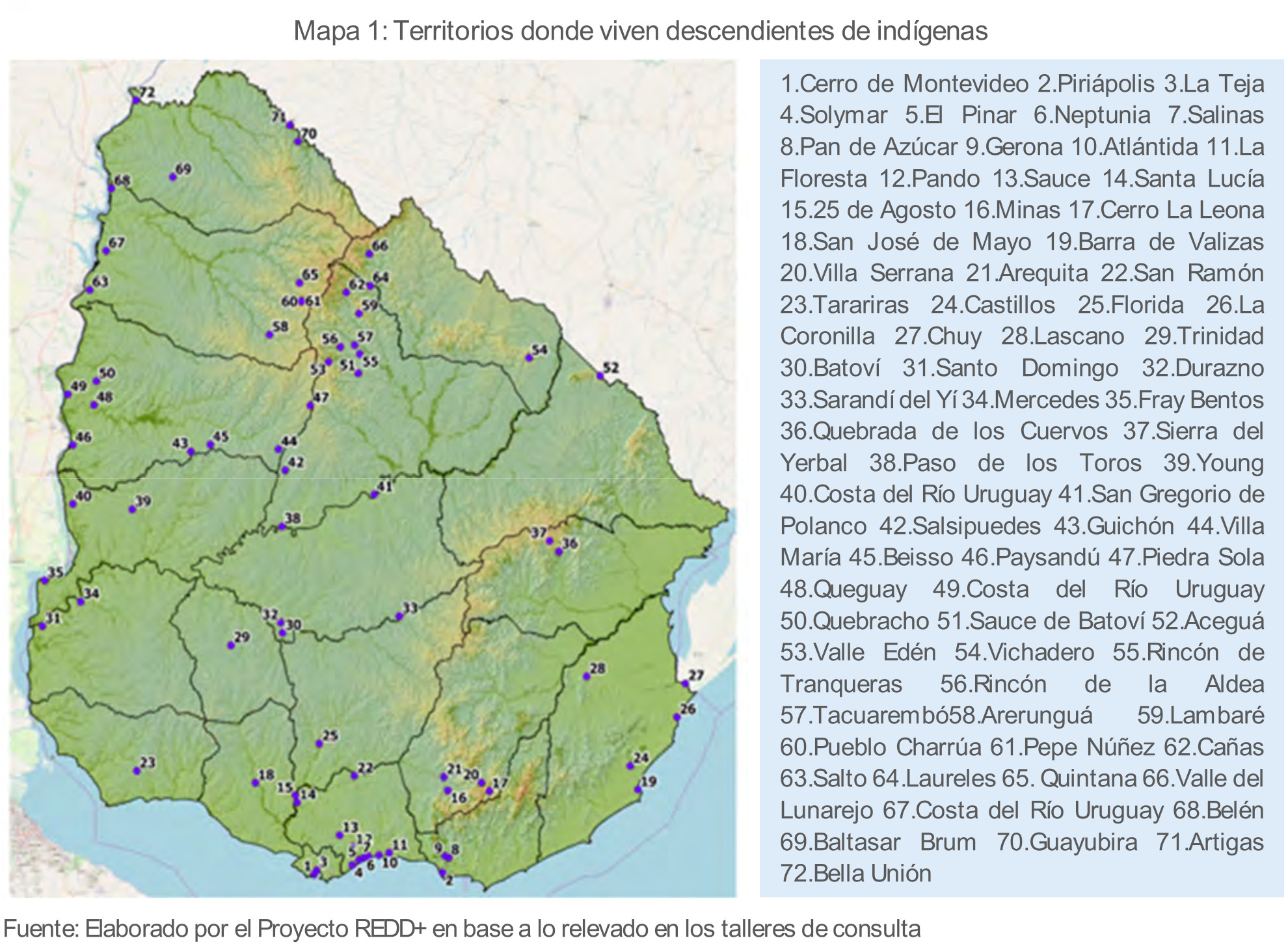
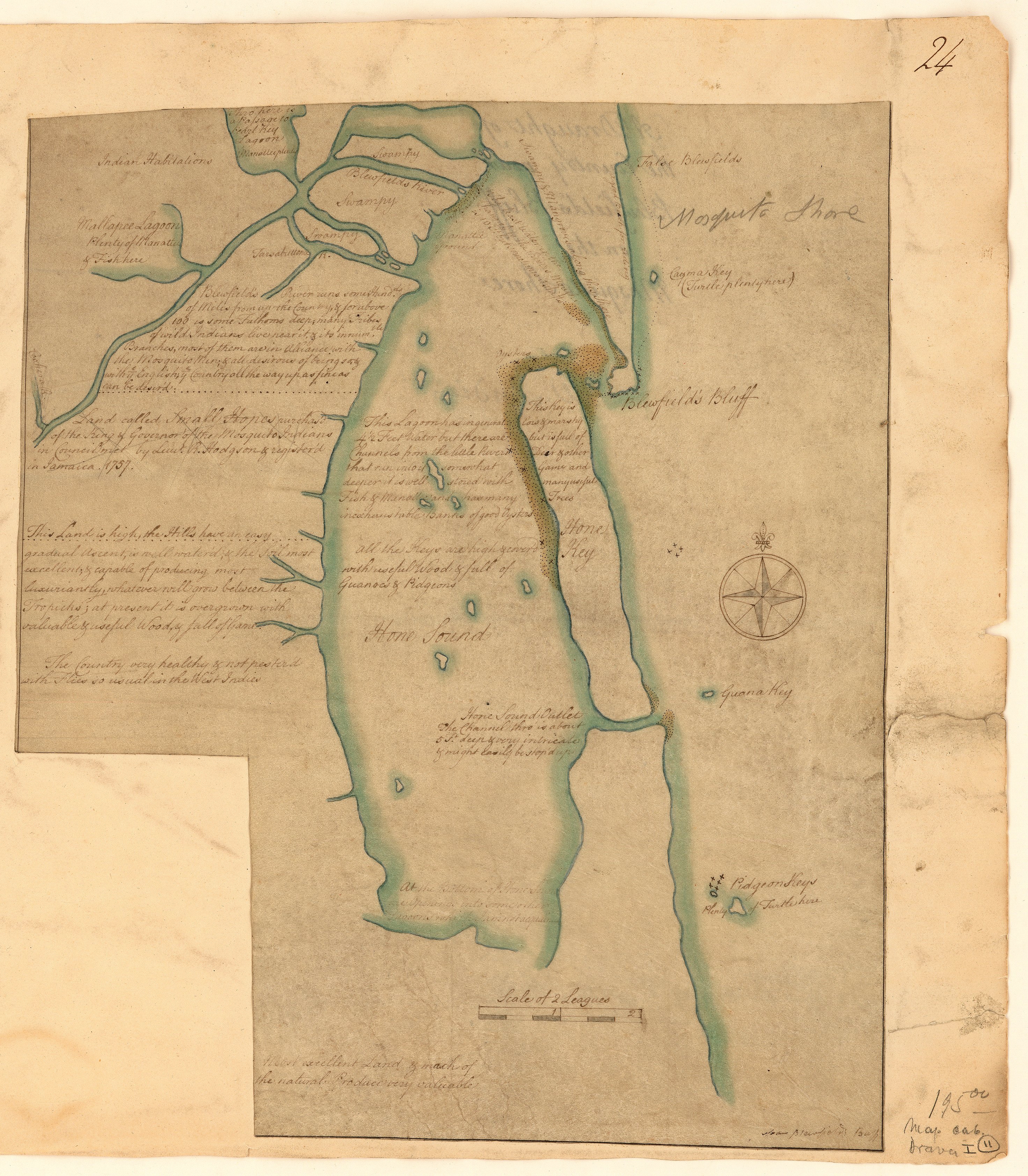
Dispossesions in the Americas

Dispossesions in the Americas

  • Lar
  • Explorar
  • Autores
  • Sobre
  • Arte
  • Corpos
  • Currículos
  • Patrimônio Cultural
  • Mapas
  • Territórios
Voltar à seção Explorar

Lendo em Inglês

Mapa 1757

A draught of the country near Blewfields Bluff on the Mosquito Shore

    Publicado: 1757

    • Baixar Imagem
    • Baixar Imagem

    Lendo em Espanhol

    Mapa 1757

    A draught of the country near Blewfields Bluff on the Mosquito Shore

      Publicado: 1757

      • Baixar Imagem
      • Baixar Imagem
      Mapa 1757

      A draught of the country near Blewfields Bluff on the Mosquito Shore

        Publicado: 1757

        • Baixar Imagem

        Povos

        • MOSQUITOS
        • INDIANS

        Citação

        A draught of the country near Blewfields Bluff on the Mosquito Shore. 1757. John Carter Brown Map Collection. C-6713. File Name: C-6713-000. https://jcb.lunaimaging.com/luna/servlet/detail/JCBMAPS~1~1~6420~115902733:A-draught-of-the-country-near-Blewf?qvq=q:Nicaragua;lc:JCBMAPS~2~2;JCBMAPS~3~3;JCB~1~1;JCB~3~3;JCBBOOKS~1~1;JCBMAPS~1~1&mi=11&trs=66#

        • Baixar Imagem

        Itens Relacionados

        CARTA ETNICA DEL GRAN CHACO EN EL UMBRAL DEL S.XX

        CARTA ETNICA DEL GRAN CHACO EN EL UMBRAL DEL S.XX

        Mapa 1875 - 1935
        Carte de l'Isle de Cayenne et de ses environs

        Carte de l'Isle de Cayenne et de ses environs

        Mapa 1764
        CARTE GÉNÉRALE DU PARAGUAY et de la Province de BUENOS-AYRES

        CARTE GÉNÉRALE DU PARAGUAY et de la Province de BUENOS-AYRES

        Mapa 1781
        El primer hombre no fue hombre, fue mujer [O primeiro homem não foi homem, foi mulher]

        El primer hombre no fue hombre, fue mujer [O primeiro homem não foi homem, foi mulher]

        Obra de arte
        La noche, la lora y los muertos [A noite, o papagaio e os mortos]

        La noche, la lora y los muertos [A noite, o papagaio e os mortos]

        Obra de arte
        Carte de la Guyane française (2ème édition). Service géographique des colonies. [Feuille 2]

        Carte de la Guyane française (2ème édition). Service géographique des colonies. [Feuille 2]

        Mapa 1926
        Territorios donde viven descendientes de indígenas

        Territorios donde viven descendientes de indígenas

        Mapa 2010 - 2020
        THE QULLASUYU IN THE 1530s – SOUTHERN DISTRICT OF THE INCA STATE

        THE QULLASUYU IN THE 1530s – SOUTHERN DISTRICT OF THE INCA STATE

        Mapa 1530

        Despossessões nas Américas

        Um projeto de

        University of Pennsylvania

        Copyright 2024

        Com o apoio de

        Mellon Foundation

        Projeto e desenvolvimento do site

        Element 84

        Créditos da arte

        A draught of the country near Blewfields Bluff on the Mosquito Shore. 1757. John Carter Brown Map Collection. C-6713. File Name: C-6713-000. https://jcb.lunaimaging.com/luna/servlet/detail/JCBMAPS~1~1~6420~115902733:A-draught-of-the-country-near-Blewf?qvq=q:Nicaragua;lc:JCBMAPS~2~2;JCBMAPS~3~3;JCB~1~1;JCB~3~3;JCBBOOKS~1~1;JCBMAPS~1~1&mi=11&trs=66#

        Páginas do site

        • Lar
        • Explorar
        • Autores
        • Sobre
        • Arte
        • Corpos
        • Currículos
        • Patrimônio Cultural
        • Mapas
        • Territórios