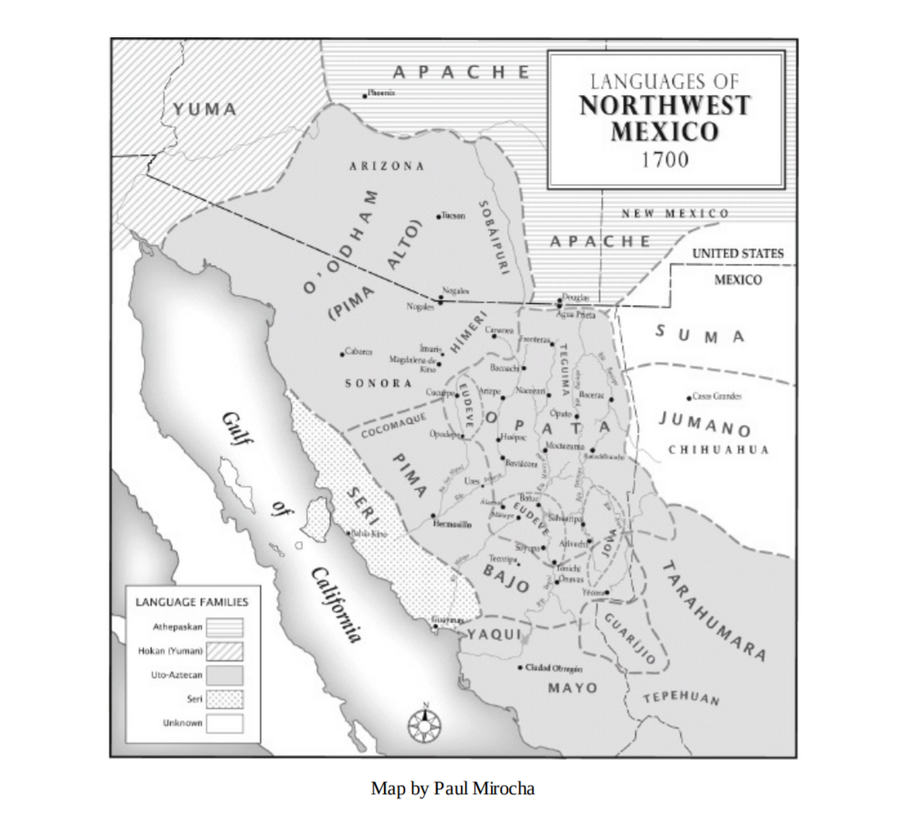
Dispossesions in the Americas

Dispossesions in the Americas

  • Lar
  • Explorar
  • Autores
  • Sobre
  • Arte
  • Corpos
  • Currículos
  • Patrimônio Cultural
  • Mapas
  • Territórios
Voltar à seção Explorar

Lendo em Inglês

Mapa 1700

Languages of Northwest Mexico

  • PAUL MIROCHA, DAVID YETMAN

Publicado: 2012

  • Baixar Imagens
  • Baixar Imagens

Lendo em Espanhola

Mapa 1700

Languages of Northwest Mexico

  • PAUL MIROCHA, DAVID YETMAN

Publicado: 2012

  • Baixar Imagens
  • Baixar Imagens
Mapa 1700

Languages of Northwest Mexico

  • PAUL MIROCHA, DAVID YETMAN

Publicado: 2012

  • Baixar Imagens

Povos

  • PIMA ALTO
  • YUMA
  • APACHE
  • SUMA
  • JUMANO
  • SOBAIPURI
  • EUDEVE
  • SERI
  • PIMA BAJO
  • OPATA
  • JOVA
  • YAQUI
  • MAYO
  • GUARIJIO
  • TEPEHUAN
  • TARAHUMARA

Citation

Yetman, David. Conflict in Colonial Sonora: Indians, Priests, and Settlers. Albuquerque: University of New Mexico Press, 2012. https://ebookcentral-proquest-com.proxy.library.upenn.edu/lib/upenn-ebooks/detail.action?docID=1104410.

  • Baixar Imagens

Itens Relacionados

Guyana

Guyana

Mapa 1800 - 1899
(séro)TROPICAL(e)

(séro)TROPICAL(e)

Obra de arte
Le Paraguay;où les R.R.P.P. de la Compagnie de Jesus ont répandu leurs missions par le Sr. d'Anville;geographe ordre. du Roi;Octobre 1733

Le Paraguay;où les R.R.P.P. de la Compagnie de Jesus ont répandu leurs missions par le Sr. d'Anville;geographe ordre. du Roi;Octobre 1733

Mapa 1733
Cours de l’Orenoque Depuis ses sources jusqu'à la Mer Avec les Rivieres qui s'y déchargent

Cours de l’Orenoque Depuis ses sources jusqu'à la Mer Avec les Rivieres qui s'y déchargent

Mapa 1764
"Territorio Indígena Cabécar de Telire"

"Territorio Indígena Cabécar de Telire"

Mapa 2010
AMÉRICA MERIDIONAL : BIBLIOTECA ESPAÑA

AMÉRICA MERIDIONAL : BIBLIOTECA ESPAÑA

Mapa 1662 - 1791
Cartografía social – confinamiento por la expansión minera en el sur de La Guajira

Cartografía social – confinamiento por la expansión minera en el sur de La Guajira

Mapa
Railroad Map of British Honduras Transportation Department of the United States Department of Commerce. Library of Congress Geography and Map Division. https://hdl.loc.gov/loc.wdl/wdl.11329

Railroad Map of British Honduras Transportation Department of the United States Department of Commerce. Library of Congress Geography and Map Division. https://hdl.loc.gov/loc.wdl/wdl.11329

Mapa 1900

Desapropriações nas Américas

Um projeto de

University of Pennsylvania

Copyright 2024

Com o apoio de

Mellon Foundation

Projeto e desenvolvimento do site

Element 84

Créditos da arte

Yetman, David. Conflict in Colonial Sonora: Indians, Priests, and Settlers. Albuquerque: University of New Mexico Press, 2012. https://ebookcentral-proquest-com.proxy.library.upenn.edu/lib/upenn-ebooks/detail.action?docID=1104410.

Páginas do site

  • Lar
  • Explorar
  • Autores
  • Sobre
  • Arte
  • Corpos
  • Currículos
  • Patrimônio Cultural
  • Mapas
  • Territórios