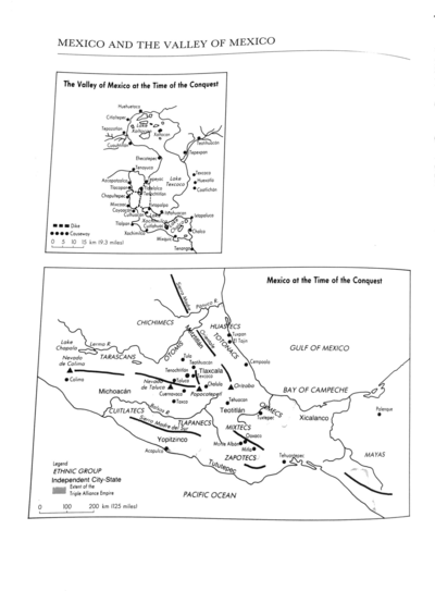
Dispossesions in the Americas

Dispossesions in the Americas

  • Lar
  • Explorar
  • Autores
  • Sobre
  • Arte
  • Corpos
  • Currículos
  • Patrimônio Cultural
  • Mapas
  • Territórios
Voltar à seção Explorar

Lendo em Inglês

Mapa 1969

Distribution of Indian Languages in Central Mexico

  • PEDRO CARRASCO

Publicado: 1969

  • Baixar Imagem
  • Baixar Imagem

Lendo em Espanhol

Mapa 1969

Distribution of Indian Languages in Central Mexico

  • PEDRO CARRASCO

Publicado: 1969

  • Baixar Imagem
  • Baixar Imagem
Mapa 1969

Distribution of Indian Languages in Central Mexico

  • PEDRO CARRASCO

Publicado: 1969

  • Baixar Imagem

Povos

  • NAHUATL
  • OTOMI
  • MAZAHUA
  • MATLATZINCA
  • OCUILTECO
  • CHICHIMECA-JONAZ
  • PAME
  • TOTONAC
  • TEPEHUA
  • HUAXTEC
  • TLAPANEC
  • CUITLATEC
  • MIXTEC

Citação

Carrasco, Pedro. "Central Mexican Highlands: Introduction." In Ethnology, edited by Robert Wauchope and Evon Z. Vogt, 579. Vols. 7-8 of Handbook of Middle American Indians. Austin: University of Texas Press, 1969. https://ebookcentral-proquest-com.proxy.library.upenn.edu/lib/upenn-ebooks/reader.action?docID=4826335&ppg=600.

  • Baixar Imagem

Itens Relacionados

TERRITORIOS DE LOS PUEBLOS Y NACIONALIDADES;TERRITORIOS DE VIDA Y AREAS PROTEGIDAS EN EL ECUADOR CONTINENTAL

TERRITORIOS DE LOS PUEBLOS Y NACIONALIDADES;TERRITORIOS DE VIDA Y AREAS PROTEGIDAS EN EL ECUADOR CONTINENTAL

Mapa 2016 - 2018
INTENDENCIA DE ZACATECAS

INTENDENCIA DE ZACATECAS

Mapa 1800
TERRITORIO DEL SEÑORÍO AYMARA DE LOS QARAQARA EN EL SIGLO XVI

TERRITORIO DEL SEÑORÍO AYMARA DE LOS QARAQARA EN EL SIGLO XVI

Mapa 1530
A Map of part of Yucatan or of that Part of the Eastern Shore Within the Bay of Honduras Alloted to Great Britain for the Cutting of Logwood, in consequence of the Convention Signed with Spain on the 14th July 1786.

A Map of part of Yucatan or of that Part of the Eastern Shore Within the Bay of Honduras Alloted to Great Britain for the Cutting of Logwood, in consequence of the Convention Signed with Spain on the 14th July 1786.

Mapa 1700
Distribución aproximada de los idiomas indígenas de Guatemala, en torno al año 1700

Distribución aproximada de los idiomas indígenas de Guatemala, en torno al año 1700

Mapa 1700
Poblaciones indígenas del Paraguay

Poblaciones indígenas del Paraguay

Mapa 2001
REGIÓN TUXTLAS, POPOLUCA-NÁHUATL DE VERACRUZ

REGIÓN TUXTLAS, POPOLUCA-NÁHUATL DE VERACRUZ

Mapa 2000
Mexico at the Time of the Conquest

Mexico at the Time of the Conquest

Mapa 1519

Despossessões nas Américas

Um projeto de

University of Pennsylvania

Copyright 2024

Com o apoio de

Mellon Foundation

Projeto e desenvolvimento do site

Element 84

Créditos da arte

Carrasco, Pedro. “Central Mexican Highlands: Introduction.” In Ethnology, edited by Robert Wauchope and Evon Z. Vogt, 579. Vols. 7-8 of Handbook of Middle American Indians. Austin: University of Texas Press, 1969. https://ebookcentral-proquest-com.proxy.library.upenn.edu/lib/upenn-ebooks/reader.action?docID=4826335&ppg=600.

Páginas do site

  • Lar
  • Explorar
  • Autores
  • Sobre
  • Arte
  • Corpos
  • Currículos
  • Patrimônio Cultural
  • Mapas
  • Territórios