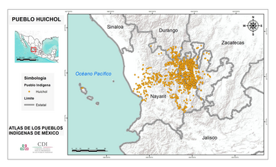
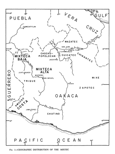
Dispossesions in the Americas

Dispossesions in the Americas

  • Lar
  • Explorar
  • Autores
  • Sobre
  • Arte
  • Corpos
  • Currículos
  • Patrimônio Cultural
  • Mapas
  • Territórios
Voltar à seção Explorar

Lendo em Inglês

Mapa 1969

Linguistic Map of Southern Mexican Highlands and Adjacent Regions at Contact Period

  • RALPH BEALS

Publicado: 1969

  • Baixar Imagens
  • Baixar Imagens

Lendo em Espanhola

Mapa 1969

Linguistic Map of Southern Mexican Highlands and Adjacent Regions at Contact Period

  • RALPH BEALS

Publicado: 1969

  • Baixar Imagens
  • Baixar Imagens
Mapa 1969

Linguistic Map of Southern Mexican Highlands and Adjacent Regions at Contact Period

  • RALPH BEALS

Publicado: 1969

  • Baixar Imagens

Povos

  • ZAPOTEC
  • CHATINO
  • MIXTEC
  • TRIQUE
  • AMUZGO
  • CUICATEC
  • MAZATEC
  • POPOLOCO
  • IZCATEC
  • CHOCHO
  • CHINANTEC
  • HUAVE
  • ZOQUE
  • MIXE
  • POPOLUCA
  • CHONTAL
  • NAHUA
  • CHONTAL DE OAXACA
  • TLAPANEC
  • CUYUMATEC
  • TEZCATEC
  • TLATZIHUITEC
  • MANCHENO
  • TUXTEC
  • TEPUZTEC
  • CUITLATEC

Citation

Beals, Ralph L. "Southern Mexican Highlands and Adjacent Coastal Regions." In Ethnology, Part 1, edited by Robert Wauchope and Evon Z. Vogt, 315. Vol. 7 of Handbook of Middle American Indians. Austin: University of Texas Press, 1969. https://ebookcentral-proquest-com.proxy.library.upenn.edu/lib/upenn-ebooks/reader.action?docID=4826335&ppg=333

  • Baixar Imagens

Itens Relacionados

PUEBLO HUICHOL

PUEBLO HUICHOL

Mapa 2020
FACSIMILE: PART OF SOUTH AMERICA BY DELISLE

FACSIMILE: PART OF SOUTH AMERICA BY DELISLE

Mapa 1700
MAPA DE LAS MISSIONES DE LA COMPANIA DE JESVS EN

MAPA DE LAS MISSIONES DE LA COMPANIA DE JESVS EN

Mapa 1749
CÓDICE FEJÉRVARY-MAYER, FOLIO 1

CÓDICE FEJÉRVARY-MAYER, FOLIO 1

Mapa 1400 - 1599
Karte von dem Eylande Caienne und Umliegenden Orten Zur allgemeinen Histoire der Reisen

Karte von dem Eylande Caienne und Umliegenden Orten Zur allgemeinen Histoire der Reisen

Mapa 1757
Itinéraire de M. Coudreau

Itinéraire de M. Coudreau

Mapa 1893
Geographic Distribution of the Mixtec

Geographic Distribution of the Mixtec

Mapa 1969
Mystequilla y Tegoantepec. Oaxaca, 1573

Mystequilla y Tegoantepec. Oaxaca, 1573

Mapa 1573

Desapropriações nas Américas

Um projeto de

University of Pennsylvania

Copyright 2024

Com o apoio de

Mellon Foundation

Projeto e desenvolvimento do site

Element 84

Créditos da arte

Beals, Ralph L. “Southern Mexican Highlands and Adjacent Coastal Regions.” In Ethnology, Part 1, edited by Robert Wauchope and Evon Z. Vogt, 315. Vol. 7 of Handbook of Middle American Indians. Austin: University of Texas Press, 1969. https://ebookcentral-proquest-com.proxy.library.upenn.edu/lib/upenn-ebooks/reader.action?docID=4826335&ppg=333

Páginas do site

  • Lar
  • Explorar
  • Autores
  • Sobre
  • Arte
  • Corpos
  • Currículos
  • Patrimônio Cultural
  • Mapas
  • Territórios