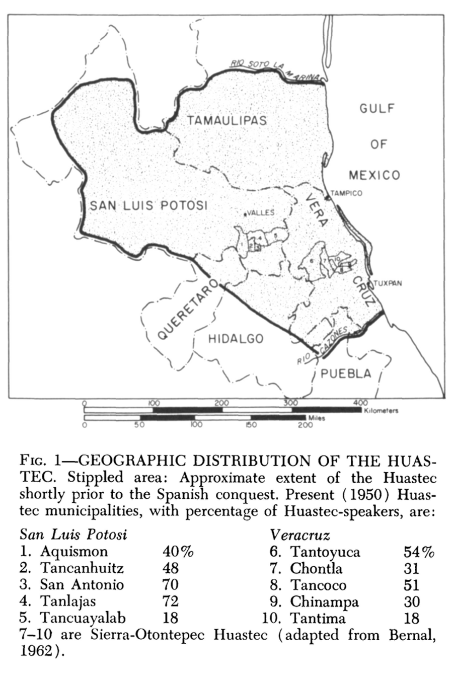
Dispossesions in the Americas

Dispossesions in the Americas

  • Lar
  • Explorar
  • Autores
  • Sobre
  • Arte
  • Corpos
  • Currículos
  • Patrimônio Cultural
  • Mapas
  • Territórios
Voltar à seção Explorar

Lendo em Inglês

Mapa 1969

Geographic Distribution of the Huastec

  • ROBERT M LAUGHLIN

Publicado: 1969

  • Baixar Imagens
  • Baixar Imagens

Lendo em Espanhola

Mapa 1969

Geographic Distribution of the Huastec

  • ROBERT M LAUGHLIN

Publicado: 1969

  • Baixar Imagens
  • Baixar Imagens
Mapa 1969

Geographic Distribution of the Huastec

  • ROBERT M LAUGHLIN

Publicado: 1969

  • Baixar Imagens

Povos

  • HUASTEC

Citation

Laughlin, Robert M. "The Huastec." In Ethnology, edited by Robert Wauchope and Evon Z. Vogt, 298. Vols. 7-8 of Handbook of Middle American Indians. Austin: University of Texas Press, 1969. https://ebookcentral-proquest-com.proxy.library.upenn.edu/lib/upenn-ebooks/reader.action?docID=4826335&ppg=314.

  • Baixar Imagens

Itens Relacionados

Plano general de Cumaná y sus contornos

Plano general de Cumaná y sus contornos

Mapa 1774
El área cultural jívara

El área cultural jívara

Mapa 1997
Comunidad Indígena Tonokoté Breáyoj - Pueblo Tonokoté

Comunidad Indígena Tonokoté Breáyoj - Pueblo Tonokoté

Mapa 2020
MAP OF YUCATAN AND THE ADJACENT TERRITORIES OF THE ITZAEX OR MAYA INDIANS, THE TIPUANS, QUECHEACHES, MOPANES, LACANDONES, CHOLES, & WITH THE DISTRICT OF VERA PAZ

MAP OF YUCATAN AND THE ADJACENT TERRITORIES OF THE ITZAEX OR MAYA INDIANS, THE TIPUANS, QUECHEACHES, MOPANES, LACANDONES, CHOLES, & WITH THE DISTRICT OF VERA PAZ

Mapa 1854
Bogando [Vogando]

Bogando [Vogando]

Obra de arte
CARTA COROGRÁFICA DE JALISCO, ZACATECAS Y COLIMA

CARTA COROGRÁFICA DE JALISCO, ZACATECAS Y COLIMA

Mapa 1824
Map representing the linguistic diversity that existed in Central America and the Gulf of Fonseca at the time of contact with the Spanish

Map representing the linguistic diversity that existed in Central America and the Gulf of Fonseca at the time of contact with the Spanish

Mapa 1522
Carte des Embouchûres des Rivières d'Ouyapoque et d'Aprouague et de la distance que contient le chemin parterre qu'a fait Monsieur de Régis au mois d'août 1738 .

Carte des Embouchûres des Rivières d'Ouyapoque et d'Aprouague et de la distance que contient le chemin parterre qu'a fait Monsieur de Régis au mois d'août 1738 .

Mapa 1738

Desapropriações nas Américas

Um projeto de

University of Pennsylvania

Copyright 2024

Com o apoio de

Mellon Foundation

Projeto e desenvolvimento do site

Element 84

Créditos da arte

Laughlin, Robert M. “The Huastec.” In Ethnology, edited by Robert Wauchope and Evon Z. Vogt, 298. Vols. 7-8 of Handbook of Middle American Indians. Austin: University of Texas Press, 1969. https://ebookcentral-proquest-com.proxy.library.upenn.edu/lib/upenn-ebooks/reader.action?docID=4826335&ppg=314.

Páginas do site

  • Lar
  • Explorar
  • Autores
  • Sobre
  • Arte
  • Corpos
  • Currículos
  • Patrimônio Cultural
  • Mapas
  • Territórios