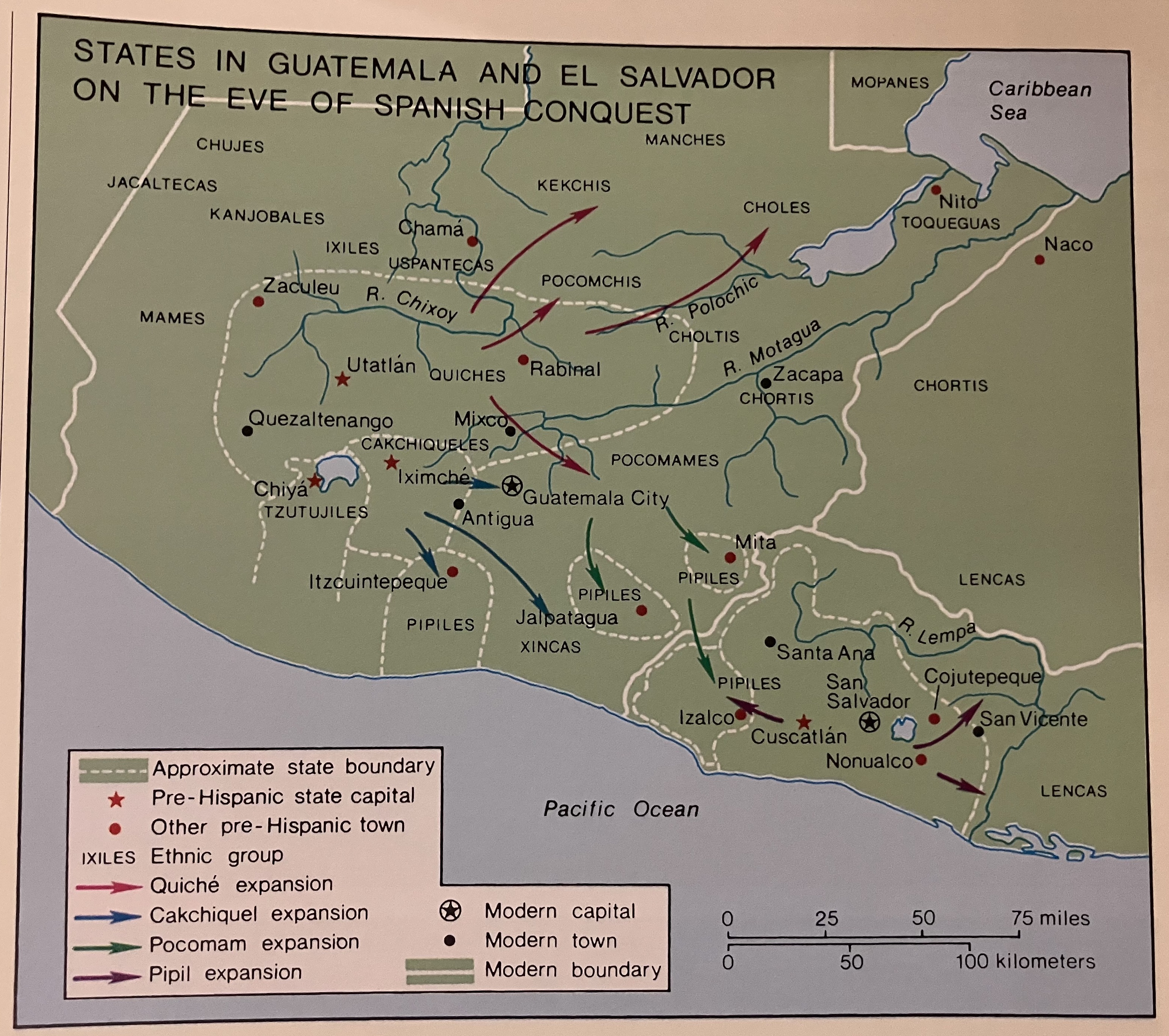
Dispossesions in the Americas

Dispossesions in the Americas

  • Lar
  • Explorar
  • Autores
  • Sobre
  • Arte
  • Corpos
  • Currículos
  • Patrimônio Cultural
  • Mapas
  • Territórios
Voltar à seção Explorar

Lendo em Inglês

Mapa 1524

States in Guatemala and el Salvador on the Eve of Spanish Conquest.

  • COTTER, JAMES

Publicado: 2003

  • Baixar Imagens
  • Baixar Imagens

Lendo em Espanhola

Mapa 1524

States in Guatemala and el Salvador on the Eve of Spanish Conquest.

  • COTTER, JAMES

Publicado: 2003

  • Baixar Imagens
  • Baixar Imagens
Mapa 1524

States in Guatemala and el Salvador on the Eve of Spanish Conquest.

  • COTTER, JAMES

Publicado: 2003

  • Baixar Imagens

Povos

  • MANCHES
  • KEKCHIS
  • CHOLES
  • CHUJES
  • JACALTECAS
  • KANJOBALES
  • IXILES
  • MAMES
  • TZUTUJILES
  • PIPILES
  • XINCAS
  • CHORTIS
  • POCOMAM
  • TOQUEGUAS

Citation

Cotter, John. "States in Guatemala and el Salvador on the Eve of Spanish Conquest." In Hall, Carolyn and Héctor Pérez Brignoli, Historical Atlas of Central America. Norman, University of California Press, 2003.

  • Baixar Imagens

Itens Relacionados

La partie méridionale de l'Amérique appelée Terre Ferme ou se trouve [sic] les provinces ou grands gouvernements de la Guiane et de la Nouvelle Grenade Cette dernière province subdivisée en Popaya;Cartagene;Ste. Marthe;Rio de la Hacha;Venezuela et Nouvelle Andalousie Le pays et le cours de la rivière des Amazones Au sud de cette carte;comme l'istme de Panama ou nord-ouest;si [sic] trouvent assé bien détaillez

La partie méridionale de l'Amérique appelée Terre Ferme ou se trouve [sic] les provinces ou grands gouvernements de la Guiane et de la Nouvelle Grenade Cette dernière province subdivisée en Popaya;Cartagene;Ste. Marthe;Rio de la Hacha;Venezuela et Nouvelle Andalousie Le pays et le cours de la rivière des Amazones Au sud de cette carte;comme l'istme de Panama ou nord-ouest;si [sic] trouvent assé bien détaillez

Mapa 1719
Indigenous Groups of the Caribbean

Indigenous Groups of the Caribbean

Mapa
ALGUNOS ESTABLECIMIENTOS ESPANOLES Y PUELOS DE INDIOS "REBELDES" A FINALES DEL SIGLO XVII

ALGUNOS ESTABLECIMIENTOS ESPANOLES Y PUELOS DE INDIOS "REBELDES" A FINALES DEL SIGLO XVII

Mapa 1600 - 1699
PUEBLO JAQARU

PUEBLO JAQARU

Mapa 2021
Distribución étnica en el siglo XVI

Distribución étnica en el siglo XVI

Mapa 1500 - 1599
Mapa VI.5 Lenguas indígenas de Venezuela

Mapa VI.5 Lenguas indígenas de Venezuela

Mapa 2009
CHART OF RIO DE LA PLATA IN SOUTH AMERICA

CHART OF RIO DE LA PLATA IN SOUTH AMERICA

Mapa 1772
Territorio Rama y Kriol: Mapa de Zonas Territoriales. Three Zones proposed by the PADA to ensure a sustainable future for the communities of Rama and Kriol

Territorio Rama y Kriol: Mapa de Zonas Territoriales. Three Zones proposed by the PADA to ensure a sustainable future for the communities of Rama and Kriol

Mapa 2000

Desapropriações nas Américas

Um projeto de

University of Pennsylvania

Copyright 2024

Com o apoio de

Mellon Foundation

Projeto e desenvolvimento do site

Element 84

Créditos da arte

Cotter, John. “States in Guatemala and el Salvador on the Eve of Spanish Conquest.” In Hall, Carolyn and Héctor Pérez Brignoli, Historical Atlas of Central America. Norman, University of California Press, 2003.

Páginas do site

  • Lar
  • Explorar
  • Autores
  • Sobre
  • Arte
  • Corpos
  • Currículos
  • Patrimônio Cultural
  • Mapas
  • Territórios