Dispossesions in the Americas

Dispossesions in the Americas

  • Lar
  • Explorar
  • Autores
  • Sobre
  • Arte
  • Corpos
  • Currículos
  • Patrimônio Cultural
  • Mapas
  • Territórios
Voltar à seção Explorar

Lendo em Inglês

Mapa 1883

Map of Guatemala/to illustrate/Mr. A.P Maudslay's Paper

  • WELLER, EDWARD

Publicado: 1883

  • Baixar Imagem
  • Baixar Imagem

Lendo em Espanhol

Mapa 1883

Map of Guatemala/to illustrate/Mr. A.P Maudslay's Paper

  • WELLER, EDWARD

Publicado: 1883

  • Baixar Imagem
  • Baixar Imagem
Mapa 1883

Map of Guatemala/to illustrate/Mr. A.P Maudslay's Paper

  • WELLER, EDWARD

Publicado: 1883

  • Baixar Imagem

Citação

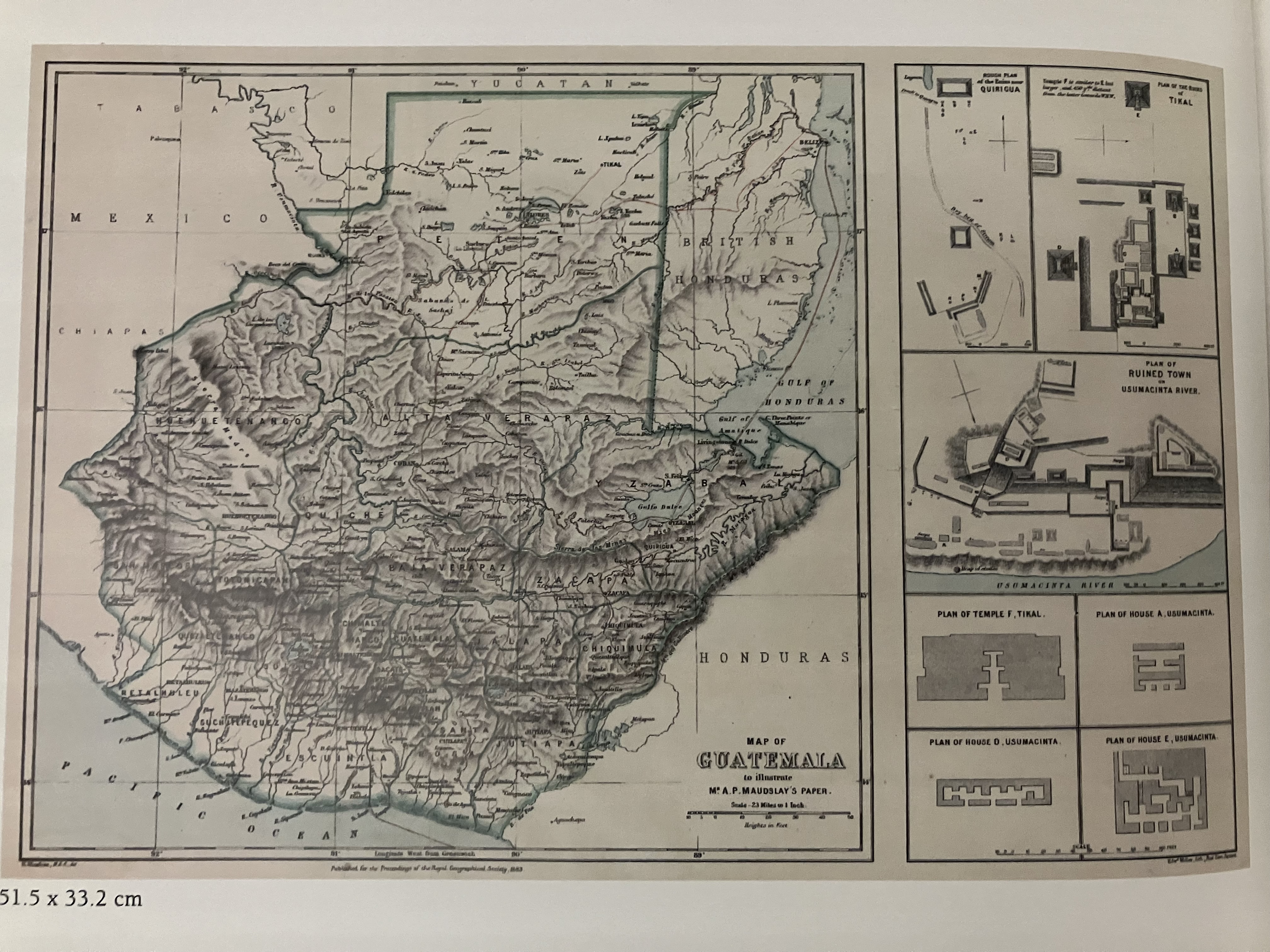
Weller, Edward "Map of Guatemala/to illustrate/Mr. A.P Maudslay's Paper. Royal Geographical Society, London, 1883. IN Jens P. Bornholt and William H. Hempstead (eds) Cuatro Siglios de Expresiones Geográficas del Istmo Centroamericano: 1500-1900. Fundacion Uno: Universidad Francisco Marroquin, Guatemala, 2007.

  • Baixar Imagem

Itens Relacionados

Fretum Magellannicum

Fretum Magellannicum

Mapa 1598
Mixe Towns

Mixe Towns

Mapa 1969
Plano del pueblo de Mariguitar y de las tierras repartidas a los indios

Plano del pueblo de Mariguitar y de las tierras repartidas a los indios

Mapa 1703
PINTURA DE GUEGUETLAN

PINTURA DE GUEGUETLAN

Mapa 1500 - 1599
An exact draught of the river of Bellese as high as the Barcadares. A new draught of the bay of Honduras by Capt. Nathaniel Uring

An exact draught of the river of Bellese as high as the Barcadares. A new draught of the bay of Honduras by Capt. Nathaniel Uring

Mapa 1726
Cabezas reducidas (Tsantsas) [Cabeças encolhidas]

Cabezas reducidas (Tsantsas) [Cabeças encolhidas]

Obra de arte
Karte von dem Eylande Caienne und Umliegenden Orten Zur allgemeinen Histoire der Reisen

Karte von dem Eylande Caienne und Umliegenden Orten Zur allgemeinen Histoire der Reisen

Mapa 1757
NEW GRANADA

NEW GRANADA

Mapa 1811

Despossessões nas Américas

Um projeto de

University of Pennsylvania

Copyright 2024

Com o apoio de

Mellon Foundation

Projeto e desenvolvimento do site

Element 84

Créditos da arte

Weller, Edward “Map of Guatemala/to illustrate/Mr. A.P Maudslay’s Paper. Royal Geographical Society, London, 1883. IN Jens P. Bornholt and William H. Hempstead (eds) Cuatro Siglios de Expresiones Geográficas del Istmo Centroamericano: 1500-1900. Fundacion Uno: Universidad Francisco Marroquin, Guatemala, 2007.

Páginas do site

  • Lar
  • Explorar
  • Autores
  • Sobre
  • Arte
  • Corpos
  • Currículos
  • Patrimônio Cultural
  • Mapas
  • Territórios