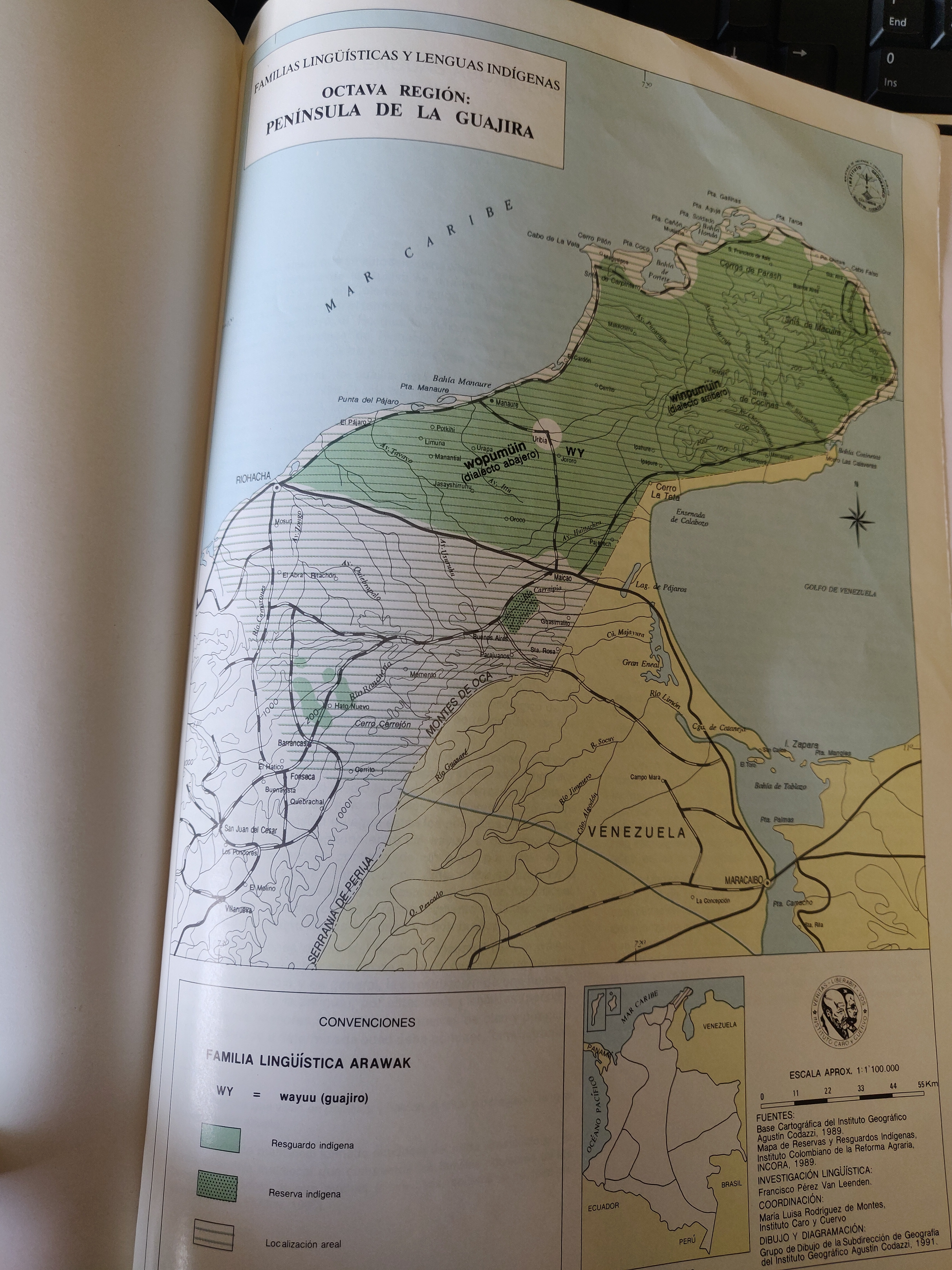
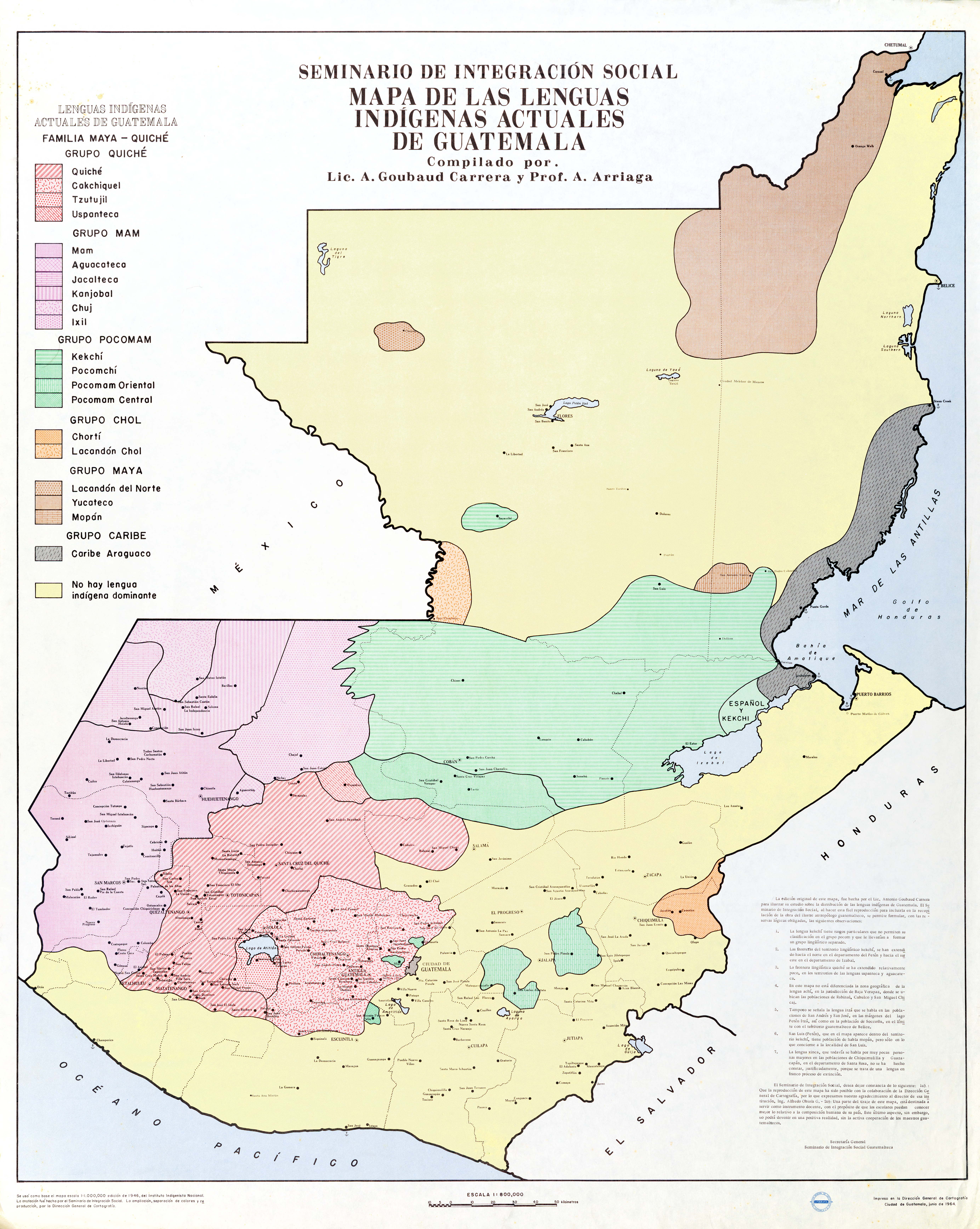
Dispossesions in the Americas

Dispossesions in the Americas

  • Lar
  • Explorar
  • Autores
  • Sobre
  • Arte
  • Corpos
  • Currículos
  • Patrimônio Cultural
  • Mapas
  • Territórios
Voltar à seção Explorar

Lendo em Inglês

Mapa 1964

Mapa De Las Lenguas Indigenas Actuales De Guatemala, Compilado Por A. Goubaud Carrera Y A. Arriaga;Seminario De Integracion Social

  • GOUBAUD CARRERA, ANTONIO, ET AL.

Publicado: 1964

  • Baixar Imagem
  • Baixar Imagem

Lendo em Espanhol

Mapa 1964

Mapa De Las Lenguas Indigenas Actuales De Guatemala, Compilado Por A. Goubaud Carrera Y A. Arriaga;Seminario De Integracion Social

  • GOUBAUD CARRERA, ANTONIO, ET AL.

Publicado: 1964

  • Baixar Imagem
  • Baixar Imagem
Mapa 1964

Mapa De Las Lenguas Indigenas Actuales De Guatemala, Compilado Por A. Goubaud Carrera Y A. Arriaga;Seminario De Integracion Social

  • GOUBAUD CARRERA, ANTONIO, ET AL.

Publicado: 1964

  • Baixar Imagem

Povos

  • QUICHE
  • CAKCHIQUEL
  • TZUTUJIL
  • USPANTECO
  • MAM
  • AGUACATECA
  • JACALTECA
  • KANJOBAL
  • CHUJ
  • IXIL
  • KEKCHI
  • POCOMCHI
  • POCOMAMORIENTAL
  • POCOMAMCENTRAL
  • CHORTI
  • LACANDONCHOL
  • LACANDONDELNORTE
  • YUCATECO
  • MOPAN
  • CARIBEARAGUACO

Citação

Goubaud Carrera, Antonio, and A. Arriaga. Mapa De Las Lenguas Indigenas Actuales De Guatemala, Compilado Por A. Goubaud Carrera Y A. Arriaga;Seminario De Integracion Social. Map. Guatemala, Guatemala: Dirección General de Cartografía, 1964. Accessed December 5, 2021. http://ufdc.ufl.edu/AA00004973/00001.

  • Baixar Imagem

Itens Relacionados

A New Map of Mexico and Adjacent Provinces Compiled From Original Documents

A New Map of Mexico and Adjacent Provinces Compiled From Original Documents

Mapa 1810
Guaná

Guaná

Mapa 2001
Carte de la cote du Bresil

Carte de la cote du Bresil

Mapa 1579
Geographical Map of the Republic of Nicaragua.

Geographical Map of the Republic of Nicaragua.

Mapa 1855
FAMILIAS LINGUÍSTICAS Y LENGUAS INDÍGENAS. OCTAVA REGION: PENINSULA DE LA GUAJIRA

FAMILIAS LINGUÍSTICAS Y LENGUAS INDÍGENAS. OCTAVA REGION: PENINSULA DE LA GUAJIRA

Mapa 1989
Laguna

Laguna

Mapa 1997
Cróquis del Rio Paraguay y alta Paraná desde el Ivoy hasta un poco más al N. del Rio Jaurú donde se puso el Marco de los límites entre España y Portugal el 14 de Enero de 1753.

Cróquis del Rio Paraguay y alta Paraná desde el Ivoy hasta un poco más al N. del Rio Jaurú donde se puso el Marco de los límites entre España y Portugal el 14 de Enero de 1753.

Mapa 1750 - 1850
Sistema guatemalteco de áreas protegidas (SIGAP) y sitios arqueológicos en 2000.

Sistema guatemalteco de áreas protegidas (SIGAP) y sitios arqueológicos en 2000.

Mapa 2000

Despossessões nas Américas

Um projeto de

University of Pennsylvania

Copyright 2024

Com o apoio de

Mellon Foundation

Projeto e desenvolvimento do site

Element 84

Créditos da arte

Goubaud Carrera, Antonio, and A. Arriaga. Mapa De Las Lenguas Indigenas Actuales De Guatemala, Compilado Por A. Goubaud Carrera Y A. Arriaga;Seminario De Integracion Social. Map. Guatemala, Guatemala: Dirección General de Cartografía, 1964. Accessed December 5, 2021. http://ufdc.ufl.edu/AA00004973/00001.

Páginas do site

  • Lar
  • Explorar
  • Autores
  • Sobre
  • Arte
  • Corpos
  • Currículos
  • Patrimônio Cultural
  • Mapas
  • Territórios