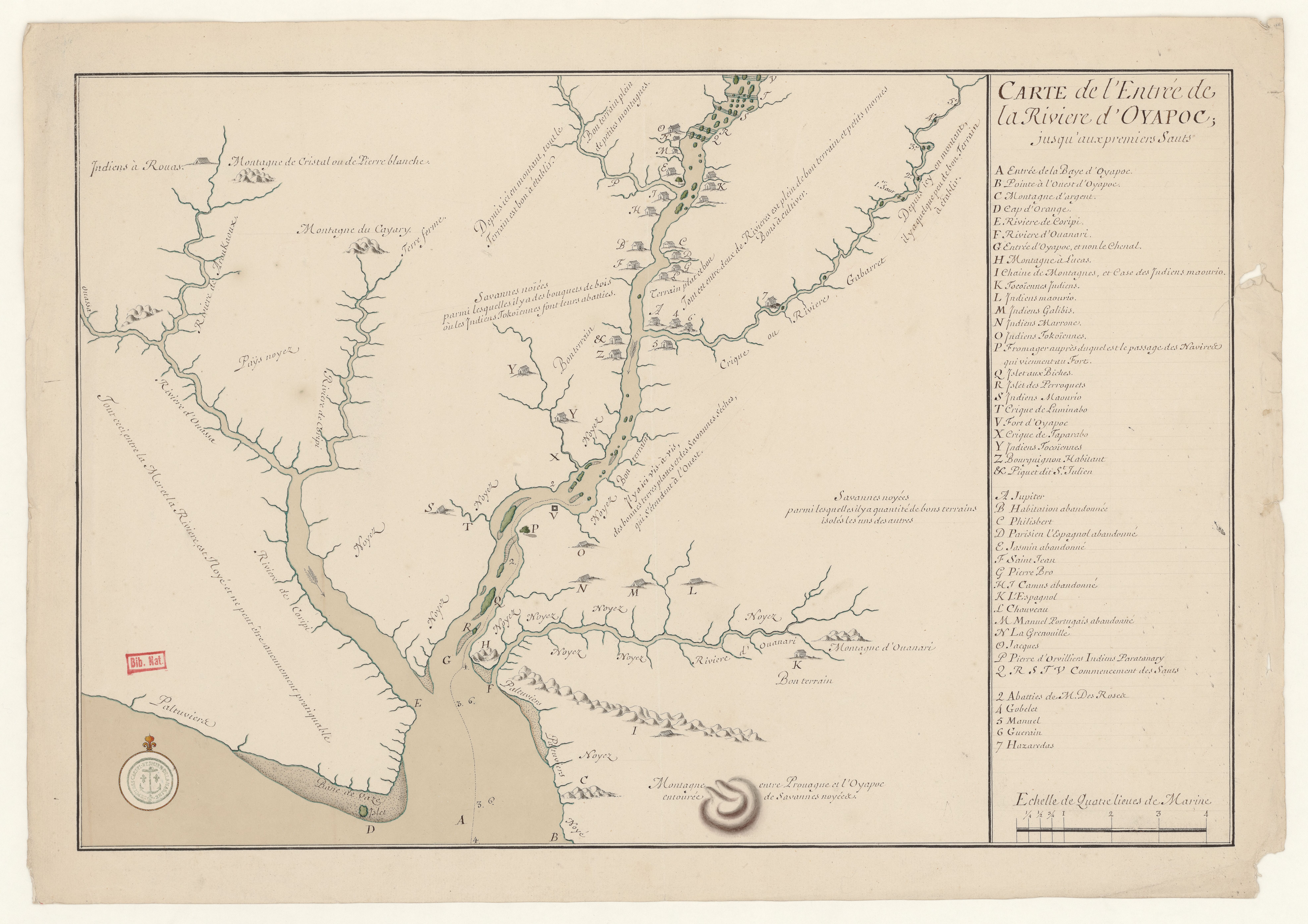
Dispossesions in the Americas

Dispossesions in the Americas

  • Lar
  • Explorar
  • Autores
  • Sobre
  • Arte
  • Corpos
  • Currículos
  • Patrimônio Cultural
  • Mapas
  • Territórios
Voltar à seção Explorar

Lendo em Inglês

Mapa 1700 - 1799

Carte de l'entrée de la Rivière d'Oyapoc jusqu'aux premiers sauts.

    Publicado: 1700

    • Baixar Imagens
    • Baixar Imagens

    Lendo em Espanhola

    Mapa 1700 - 1799

    Carte de l'entrée de la Rivière d'Oyapoc jusqu'aux premiers sauts.

      Publicado: 1700

      • Baixar Imagens
      • Baixar Imagens
      Mapa 1700 - 1799

      Carte de l'entrée de la Rivière d'Oyapoc jusqu'aux premiers sauts.

        Publicado: 1700

        • Baixar Imagens

        Povos

        • GALIBIS
        • MAOURIO
        • MARRONE
        • ROUAS
        • TOCOIENNES
        • TOKOIENNES

        Citation

        Carte de l'entrée de la Rivière d'Oyapoc jusqu'aux premiers sauts. Gallica. Last modified: September 28, 2015. Accessed, July 31, 2023. https://gallica.bnf.fr/ark:/12148/btv1b531036642

        • Baixar Imagens

        Itens Relacionados

        El dueño de coronavirus [O dono do coronavírus]

        El dueño de coronavirus [O dono do coronavírus]

        Obra de arte
        REGIÓN FRONTERA SUR

        REGIÓN FRONTERA SUR

        Mapa 2000
        CARTE DES REPUBLIQUES DE L'EQUATEUR;DE COLOMBIE;DE VENEZUELA;ET GUYANES FRANCAISE;HOLLANDAISE;ET ANGLAISE

        CARTE DES REPUBLIQUES DE L'EQUATEUR;DE COLOMBIE;DE VENEZUELA;ET GUYANES FRANCAISE;HOLLANDAISE;ET ANGLAISE

        Mapa 1875
        Cùst, van, Brasilia

        Cùst, van, Brasilia

        Mapa 1600 - 1699
        Nova Hispania et Nova Galicia

        Nova Hispania et Nova Galicia

        Mapa 1636
        Indigenous languages in Guatemala

        Indigenous languages in Guatemala

        Mapa
        SÜDAMERIKA, NÖRDLICHE HÄLFTE

        SÜDAMERIKA, NÖRDLICHE HÄLFTE

        Mapa 1902
        Location of the main settlements on the Lenca-Chortí-Nahua-Pipil frontier, 1530-1539. (Taken from Lara-Pinto 2009 with modifications.)

        Location of the main settlements on the Lenca-Chortí-Nahua-Pipil frontier, 1530-1539. (Taken from Lara-Pinto 2009 with modifications.)

        Mapa 1530 - 1539

        Desapropriações nas Américas

        Um projeto de

        University of Pennsylvania

        Copyright 2024

        Com o apoio de

        Mellon Foundation

        Projeto e desenvolvimento do site

        Element 84

        Créditos da arte

        Carte de l’entrée de la Rivière d’Oyapoc jusqu’aux premiers sauts. Gallica. Last modified: September 28, 2015. Accessed, July 31, 2023. https://gallica.bnf.fr/ark:/12148/btv1b531036642

        Páginas do site

        • Lar
        • Explorar
        • Autores
        • Sobre
        • Arte
        • Corpos
        • Currículos
        • Patrimônio Cultural
        • Mapas
        • Territórios