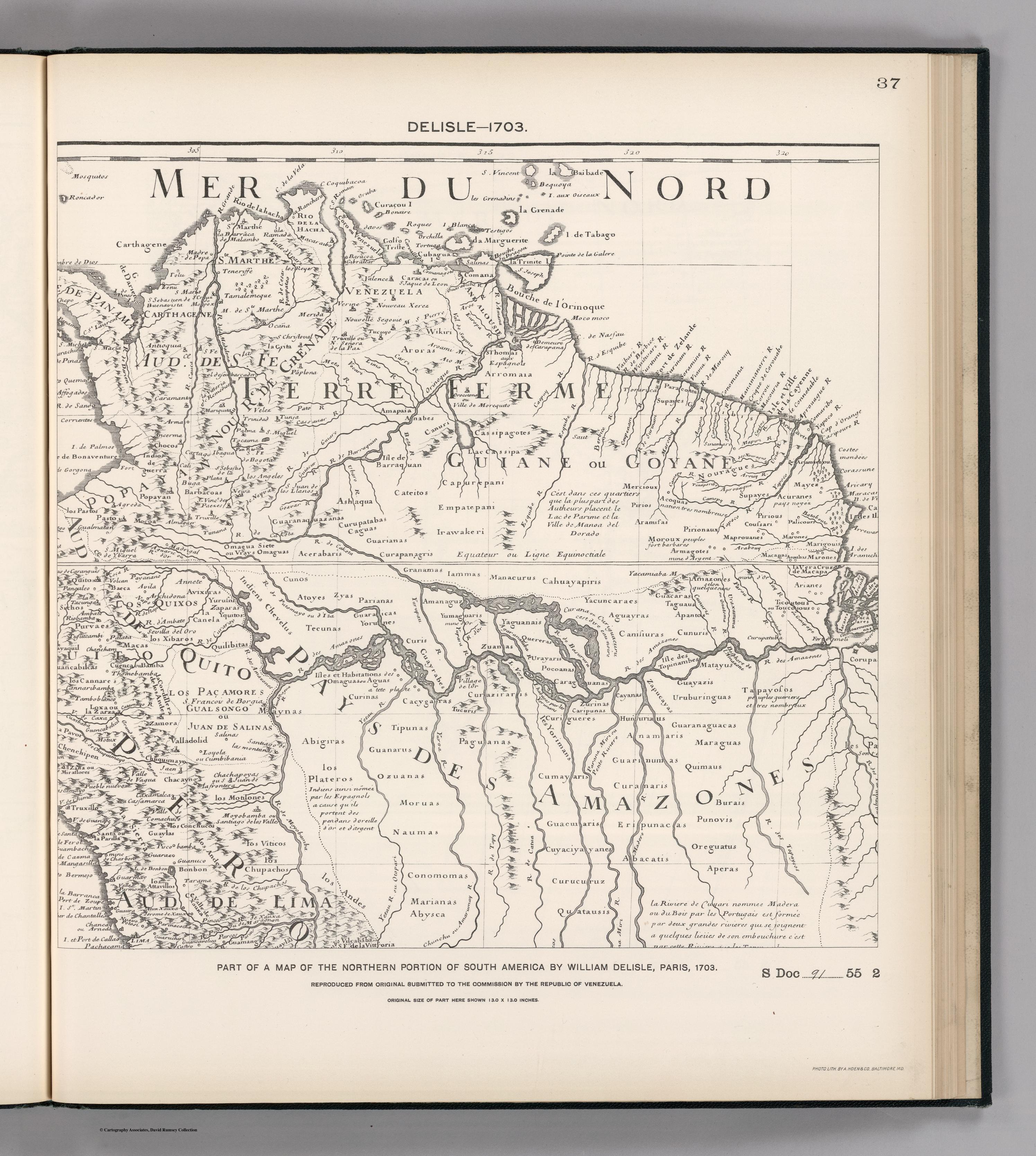
Dispossesions in the Americas

Dispossesions in the Americas

  • Lar
  • Explorar
  • Autores
  • Sobre
  • Arte
  • Corpos
  • Currículos
  • Patrimônio Cultural
  • Mapas
  • Territórios
Voltar à seção Explorar

Lendo em Inglês

Mapa 1600 - 1699

Embouchure de la Rivière des Amazones et partie de la coste de Guiane.

    Publicado: 1600

    • Baixar Imagem
    • Baixar Imagem

    Lendo em Espanhol

    Mapa 1600 - 1699

    Embouchure de la Rivière des Amazones et partie de la coste de Guiane.

      Publicado: 1600

      • Baixar Imagem
      • Baixar Imagem
      Mapa 1600 - 1699

      Embouchure de la Rivière des Amazones et partie de la coste de Guiane.

        Publicado: 1600

        • Baixar Imagem

        Povos

        • ALICOURA
        • ANIVIANNES
        • ARAMAYON
        • AROUHAA
        • COCHONSDEBOIS
        • COUSSARY
        • ITOUTANES
        • KARANARIO
        • KARANNES
        • KARIACOYAUX
        • KOUROURAOUA
        • MAKAOUANY
        • MAPROUANNES
        • MARAONNES
        • MAYEZ
        • MAYKA
        • OUAYEMPIS
        • OUAYES
        • OUEN
        • OURAMIO
        • OURANAYOU
        • OYANENGA
        • PALANKES
        • PALICOUR
        • PIRIOUX
        • ROUKAKAITS
        • TAPIRI
        • TOKOYENNES

        Citação

        Embouchure de la Rivière des Amazones et partie de la coste de Guiane. Gallica. Last modified: September 28, 2015. Accessed, June 28, 2023. https://gallica.bnf.fr/ark:/12148/btv1b531032544

        • Baixar Imagem

        Itens Relacionados

        Jalacte

        Jalacte

        Mapa 1997
        Geographic Distribution of the Huastec

        Geographic Distribution of the Huastec

        Mapa 1969
        FIGURAS DE ORDENAMIENTO TERRITORIAL EN LA SNSM

        FIGURAS DE ORDENAMIENTO TERRITORIAL EN LA SNSM

        Mapa 2009
        Blue Creek

        Blue Creek

        Mapa 1997
        FACSIMILE: NORTHERN PORTION OF SOUTH AMERICA

        FACSIMILE: NORTHERN PORTION OF SOUTH AMERICA

        Mapa 1703
        Territorio Mapuche hacia 1540

        Territorio Mapuche hacia 1540

        Mapa 1540
        PUEBLO TSELTAL

        PUEBLO TSELTAL

        Mapa 2020
        Pueblos Taínos

        Pueblos Taínos

        Mapa 2000 - 2015

        Despossessões nas Américas

        Um projeto de

        University of Pennsylvania

        Copyright 2024

        Com o apoio de

        Mellon Foundation

        Projeto e desenvolvimento do site

        Element 84

        Créditos da arte

        Embouchure de la Rivière des Amazones et partie de la coste de Guiane. Gallica. Last modified: September 28, 2015. Accessed, June 28, 2023. https://gallica.bnf.fr/ark:/12148/btv1b531032544

        Páginas do site

        • Lar
        • Explorar
        • Autores
        • Sobre
        • Arte
        • Corpos
        • Currículos
        • Patrimônio Cultural
        • Mapas
        • Territórios