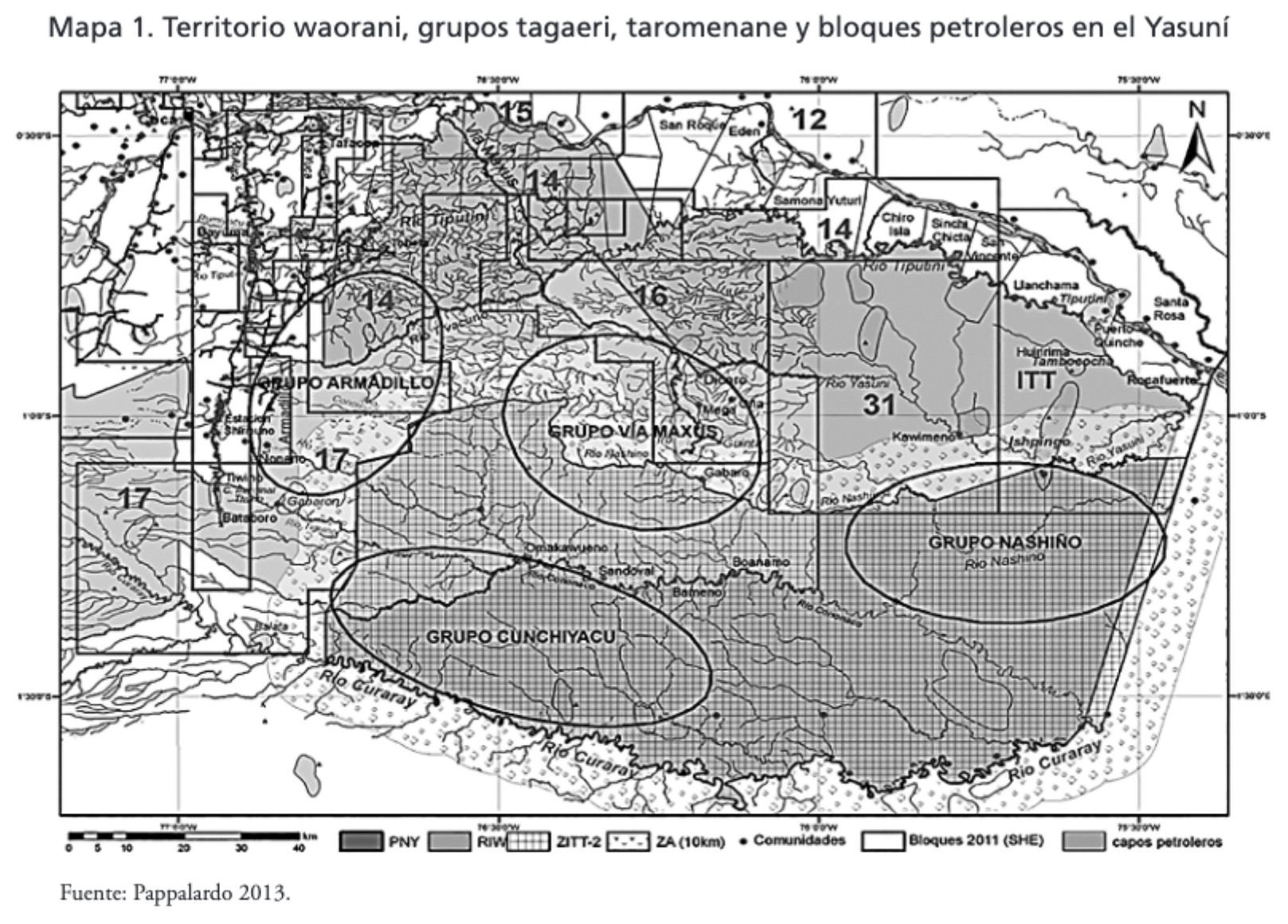
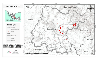
Dispossesions in the Americas

Dispossesions in the Americas

  • Lar
  • Explorar
  • Autores
  • Sobre
  • Arte
  • Corpos
  • Currículos
  • Patrimônio Cultural
  • Mapas
  • Territórios
Voltar à seção Explorar

Lendo em Inglês

Mapa 2013

MAPA 1. TERRITORIO WAORANI;GRUPOS TAGAERI;TAROMENANE Y BLOQUES PETROLEROS EN EL YASUNÍ

  • EUGENIO PAPPALARDO

Publicado: 2017

  • Baixar Imagem
  • Baixar Imagem

Lendo em Espanhol

Mapa 2013

MAPA 1. TERRITORIO WAORANI;GRUPOS TAGAERI;TAROMENANE Y BLOQUES PETROLEROS EN EL YASUNÍ

  • EUGENIO PAPPALARDO

Publicado: 2017

  • Baixar Imagem
  • Baixar Imagem
Mapa 2013

MAPA 1. TERRITORIO WAORANI;GRUPOS TAGAERI;TAROMENANE Y BLOQUES PETROLEROS EN EL YASUNÍ

  • EUGENIO PAPPALARDO

Publicado: 2017

  • Baixar Imagem

Povos

  • WAORANI
  • TAGAERI
  • TAROMENANE

Citação

Narváez Quiñónez;Iván Tarcicio. “Amazonía: Cambio de La Comprensión de La Territorialidad Al Interior Del Territorio Waorani (Los Derechos Indígenas)/ Amazon: Change of the Understanding of the Territoriality to the Interior of the Waorani Territory (indigenous Rights).” Eutopía.;no. 12 (2017). https://revistas.flacsoandes.edu.ec/eutopia/article/view/2906/2052

  • Baixar Imagem

Itens Relacionados

Paskaerte vande cust van Westindien van R. Desaguadera tot C. de Honduras / beschreven door Arent Roggeveen

Paskaerte vande cust van Westindien van R. Desaguadera tot C. de Honduras / beschreven door Arent Roggeveen

Mapa 1675
Main Native Groups in Eastern Oaxaca

Main Native Groups in Eastern Oaxaca

Mapa 1969
Cultural groups discussed in the text

Cultural groups discussed in the text

Mapa 2010
GUANAJUATO

GUANAJUATO

Mapa 2015
[Guyane française entre l'île du Diable, le Cassipour, et les Sources de l'Oyapok / par Jean-Baptiste d'Anville]

[Guyane française entre l'île du Diable, le Cassipour, et les Sources de l'Oyapok / par Jean-Baptiste d'Anville]

Mapa 1700 - 1799
TITLED INDIGENOUS TERRITORIES (TIOCs) IN THE BOLIVIAN HIGH PLATEAU by 2011

TITLED INDIGENOUS TERRITORIES (TIOCs) IN THE BOLIVIAN HIGH PLATEAU by 2011

Mapa 2011
MAP 4. DISTRIBUTION OF ETHNIC GROUPS IN THE ORIENTE ON THE EVE OF SPANISH CONQUEST

MAP 4. DISTRIBUTION OF ETHNIC GROUPS IN THE ORIENTE ON THE EVE OF SPANISH CONQUEST

Mapa 1535
How Rivers Think [Como os rios pensam]

How Rivers Think [Como os rios pensam]

Obra de arte

Despossessões nas Américas

Um projeto de

University of Pennsylvania

Copyright 2024

Com o apoio de

Mellon Foundation

Projeto e desenvolvimento do site

Element 84

Créditos da arte

Narváez Quiñónez;Iván Tarcicio. “Amazonía: Cambio de La Comprensión de La Territorialidad Al Interior Del Territorio Waorani (Los Derechos Indígenas)/ Amazon: Change of the Understanding of the Territoriality to the Interior of the Waorani Territory (indigenous Rights).” Eutopía.;no. 12 (2017). https://revistas.flacsoandes.edu.ec/eutopia/article/view/2906/2052

Páginas do site

  • Lar
  • Explorar
  • Autores
  • Sobre
  • Arte
  • Corpos
  • Currículos
  • Patrimônio Cultural
  • Mapas
  • Territórios