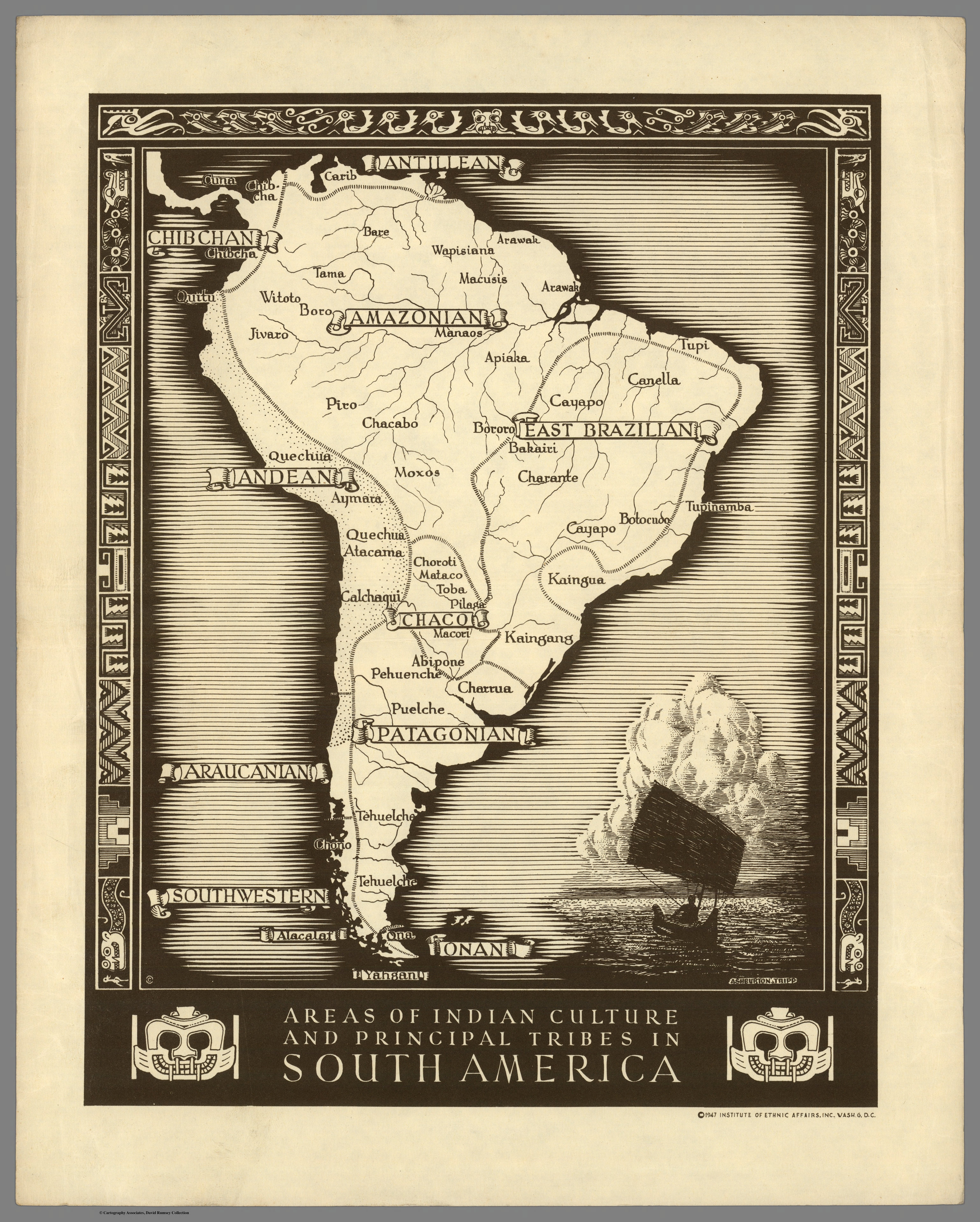
Dispossesions in the Americas

Dispossesions in the Americas

  • Lar
  • Explorar
  • Autores
  • Sobre
  • Arte
  • Corpos
  • Currículos
  • Patrimônio Cultural
  • Mapas
  • Territórios
Voltar à seção Explorar

Lendo em Inglês

Mapa 1500 - 1900

Areas of Indian Culture and Principal Tribes in South America

  • Institute of Ethnic Affairs

Publicado: 1947

  • Baixar Imagens
  • Baixar Imagens

Lendo em Espanhola

Mapa 1500 - 1900

Areas of Indian Culture and Principal Tribes in South America

  • Institute of Ethnic Affairs

Publicado: 1947

  • Baixar Imagens
  • Baixar Imagens
Mapa 1500 - 1900

Areas of Indian Culture and Principal Tribes in South America

  • Institute of Ethnic Affairs

Publicado: 1947

  • Baixar Imagens

Povos

  • ABIPONE
  • ALACALAF
  • APIAKA
  • ARAWAK
  • ATACAMA
  • AYMARA
  • BAKAIRI
  • BARE
  • BORO
  • BORORO
  • BOTOCUDO
  • CALCHAQUI
  • CANELLA
  • CARIB
  • CAYAPO
  • CHACABO
  • CHARANTE
  • CHARRUA
  • CHIBCHA
  • CHONO
  • CHOROTI
  • CUNA
  • JIVARO
  • KAINGANG
  • MACORI
  • MACUSIS
  • MANAOS
  • MATACO
  • MOXOS
  • ONA
  • PEHUENCHE
  • PILAGA
  • PIRO
  • PUELCHE
  • QUECHUA
  • QUITU
  • TAMA
  • TEHUELCHE
  • TOBA
  • TUPI
  • TUPINAMBAL WAPISIANA
  • WITOTO
  • YAHGAN

Citation

Institute of Ethnic Affairs. Areas of Indian Culture and Principal Tribes in South America. David Rumsey Map Collection. Accessed, April 03, 2024. https://www.davidrumsey.com/luna/servlet/detail/RUMSEY~8~1~269040~90043130

  • Baixar Imagens

Itens Relacionados

MAPA LOCAL DE TOCHPAN

MAPA LOCAL DE TOCHPAN

Mapa 1400 - 1499
Reducción del territorio Barí 1950 -1970

Reducción del territorio Barí 1950 -1970

Mapa 1950 - 1970
Mauricio

Mauricio

Obra de arte
Carte nouvelle de la France Equinoctiale

Carte nouvelle de la France Equinoctiale

Mapa 1665
Distribucion Territorial Actual de las Comunidades Atacamenas

Distribucion Territorial Actual de las Comunidades Atacamenas

Mapa 1993
Delimitación de la Gran Nación Wayuu

Delimitación de la Gran Nación Wayuu

Mapa 2015
Map of the Mayance Nations and Languages

Map of the Mayance Nations and Languages

Mapa 1000 - 1500
PROVINCIA DO GRAO PARÁ

PROVINCIA DO GRAO PARÁ

Mapa 1800 - 1850

Desapropriações nas Américas

Um projeto de

University of Pennsylvania

Copyright 2024

Com o apoio de

Mellon Foundation

Projeto e desenvolvimento do site

Element 84

Créditos da arte

Institute of Ethnic Affairs. Areas of Indian Culture and Principal Tribes in South America. David Rumsey Map Collection. Accessed, April 03, 2024. https://www.davidrumsey.com/luna/servlet/detail/RUMSEY~8~1~269040~90043130

Páginas do site

  • Lar
  • Explorar
  • Autores
  • Sobre
  • Arte
  • Corpos
  • Currículos
  • Patrimônio Cultural
  • Mapas
  • Territórios