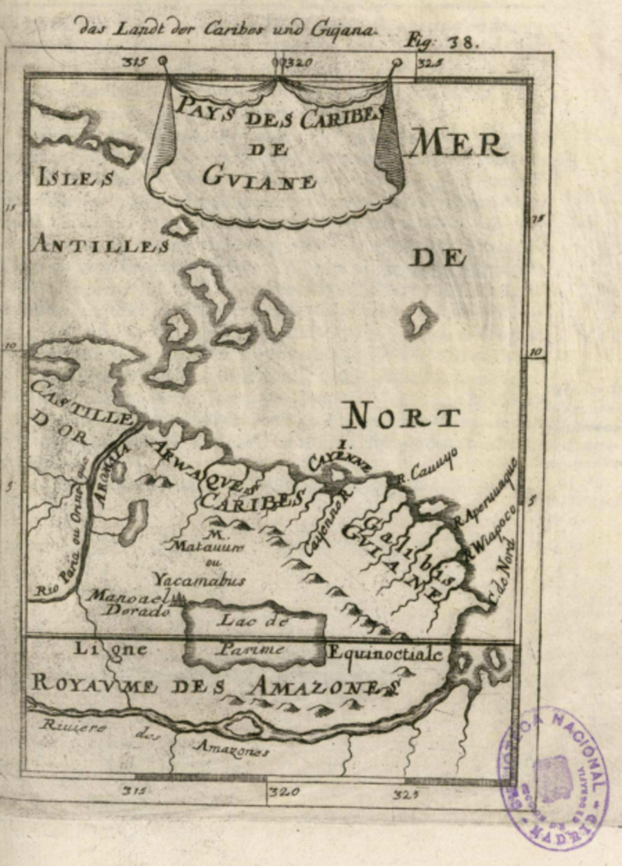
Dispossesions in the Americas

Dispossesions in the Americas

  • Lar
  • Explorar
  • Autores
  • Sobre
  • Arte
  • Corpos
  • Currículos
  • Patrimônio Cultural
  • Mapas
  • Territórios
Voltar à seção Explorar

Lendo em Inglês

Mapa 1600 - 1699

Pays des Caribes de Guiane

  • Manesson-Mallet, Allain

Publicado: 1686

  • Baixar Imagens
  • Baixar Imagens

Lendo em Espanhola

Mapa 1600 - 1699

Pays des Caribes de Guiane

  • Manesson-Mallet, Allain

Publicado: 1686

  • Baixar Imagens
  • Baixar Imagens
Mapa 1600 - 1699

Pays des Caribes de Guiane

  • Manesson-Mallet, Allain

Publicado: 1686

  • Baixar Imagens

Povos

  • ARWAQUES
  • CARIBES
  • GALIBIS
  • MATAUURE
  • YACAMABUS

Citation

Manesson-Mallet, Allain, Description de l'Univers, contenant les differents systemes du Monde . Biblioteca Nacional de España. 1686 Accessed, August 14, 2023. http://bdh-rd.bne.es/viewer.vm?id=0000000737

  • Baixar Imagens

Itens Relacionados

La France. Amérique Française (Guyane). Afrique Française (Illes S.te Marie, Nossi-bé, Nossi-cumba, Nossi-fali &.).

La France. Amérique Française (Guyane). Afrique Française (Illes S.te Marie, Nossi-bé, Nossi-cumba, Nossi-fali &.).

Mapa 1869
Government map of Nicaragua : from the latest surveys ordered by President Patricio Rivas and Genl. William Walker ;executed under the supervision of the Señor Fermín Ferrer;Governor of the Western Department;1856

Government map of Nicaragua : from the latest surveys ordered by President Patricio Rivas and Genl. William Walker ;executed under the supervision of the Señor Fermín Ferrer;Governor of the Western Department;1856

Mapa 1800 - 1856
"Descripción del Valle de Chimo y planisphérica de la Ciudad de Truxillo del Perú".

"Descripción del Valle de Chimo y planisphérica de la Ciudad de Truxillo del Perú".

Mapa 1760
MAPA DE SAN DIEGO XOCOYUCAN

MAPA DE SAN DIEGO XOCOYUCAN

Mapa 1500 - 1599
ZENU

ZENU

Mapa
Chamán asháninka [Xamã asháninka]

Chamán asháninka [Xamã asháninka]

Obra de arte
Carte de la Guyane Francoise ou France Equinoxiale. Grand, beau et très fertile Pays de l'Amerique Meridionale, située entre la Riviere de Marauny et le Cap Nord

Carte de la Guyane Francoise ou France Equinoxiale. Grand, beau et très fertile Pays de l'Amerique Meridionale, située entre la Riviere de Marauny et le Cap Nord

Mapa 1763
Popoloca Towns

Popoloca Towns

Mapa 1950

Desapropriações nas Américas

Um projeto de

University of Pennsylvania

Copyright 2024

Com o apoio de

Mellon Foundation

Projeto e desenvolvimento do site

Element 84

Créditos da arte

Manesson-Mallet, Allain, Description de l’Univers, contenant les differents systemes du Monde . Biblioteca Nacional de España. 1686 Accessed, August 14, 2023. http://bdh-rd.bne.es/viewer.vm?id=0000000737

Páginas do site

  • Lar
  • Explorar
  • Autores
  • Sobre
  • Arte
  • Corpos
  • Currículos
  • Patrimônio Cultural
  • Mapas
  • Territórios