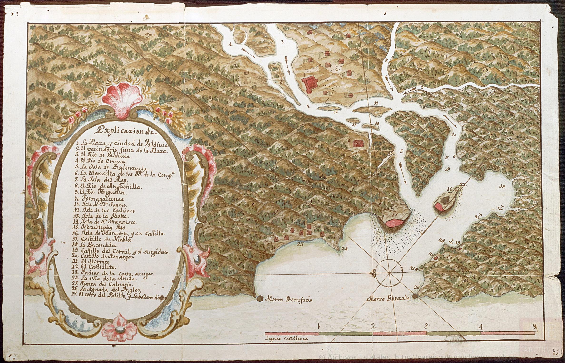
Dispossesions in the Americas

Dispossesions in the Americas

  • Lar
  • Explorar
  • Autores
  • Sobre
  • Arte
  • Corpos
  • Currículos
  • Patrimônio Cultural
  • Mapas
  • Territórios
Voltar à seção Explorar

Lendo em Inglês

Mapa 1794

CHART containing the greater part of the SOUTH SEA to the South of the LINE, with the ISLANDS dispersed thro' the same

  • WHITTLE, JAMES

Publicado: 1794

  • Baixar Imagem
  • Baixar Imagem

Lendo em Espanhol

Mapa 1794

CHART containing the greater part of the SOUTH SEA to the South of the LINE, with the ISLANDS dispersed thro' the same

  • WHITTLE, JAMES

Publicado: 1794

  • Baixar Imagem
  • Baixar Imagem
Mapa 1794

CHART containing the greater part of the SOUTH SEA to the South of the LINE, with the ISLANDS dispersed thro' the same

  • WHITTLE, JAMES

Publicado: 1794

  • Baixar Imagem

Povos

  • TUPINAMBAS
  • TAPUYAS
  • CHIQUITOS
  • GUAYCURUS
  • CHARUAS
  • PATAGOUS

Citação

Whittle, James, and Robert Laurie. Chart containing the greater part of the South Sea to the South of the Line, with the Islands dispersed thro' the same. Map. London: Laurie & Whittle, 1794. Accessed August 13, 2023. https://gallica.bnf.fr/ark:/12148/btv1b53123130r/f1.item.

  • Baixar Imagem

Itens Relacionados

Mapa de la Ciudad de Valdivia y territorios de sus cercanías

Mapa de la Ciudad de Valdivia y territorios de sus cercanías

Mapa 1785
Mapa que comprehende la mayor parte del reyno de Goatemala;Provincias de Yucatan;Vera-Paz;Honduras;Nicaragua;Costa-Rica;Veraguas y parte de Tierra Firme.

Mapa que comprehende la mayor parte del reyno de Goatemala;Provincias de Yucatan;Vera-Paz;Honduras;Nicaragua;Costa-Rica;Veraguas y parte de Tierra Firme.

Mapa 1738
San Juan Baptista, San Luys Tezontla y Santa María Nochtongo. Oaxaca, 1579

San Juan Baptista, San Luys Tezontla y Santa María Nochtongo. Oaxaca, 1579

Mapa 1579
PUEBLO IXCATECO

PUEBLO IXCATECO

Mapa 2020
Virus de imunomunodeficiencia humana y la invisibilidad del condón [Vírus da imunodeficiência humana e a invisibilidade do preservativo]

Virus de imunomunodeficiencia humana y la invisibilidad del condón [Vírus da imunodeficiência humana e a invisibilidade do preservativo]

Obra de arte
Territorios donde viven descendientes de indígenas

Territorios donde viven descendientes de indígenas

Mapa 2010 - 2020
PINTURA DE GUEGUETLAN

PINTURA DE GUEGUETLAN

Mapa 1500 - 1599
Amerique Meridionale

Amerique Meridionale

Mapa 1600 - 1699

Despossessões nas Américas

Um projeto de

University of Pennsylvania

Copyright 2024

Com o apoio de

Mellon Foundation

Projeto e desenvolvimento do site

Element 84

Créditos da arte

Whittle, James, and Robert Laurie. Chart containing the greater part of the South Sea to the South of the Line, with the Islands dispersed thro’ the same. Map. London: Laurie & Whittle, 1794. Accessed August 13, 2023. https://gallica.bnf.fr/ark:/12148/btv1b53123130r/f1.item.

Páginas do site

  • Lar
  • Explorar
  • Autores
  • Sobre
  • Arte
  • Corpos
  • Currículos
  • Patrimônio Cultural
  • Mapas
  • Territórios