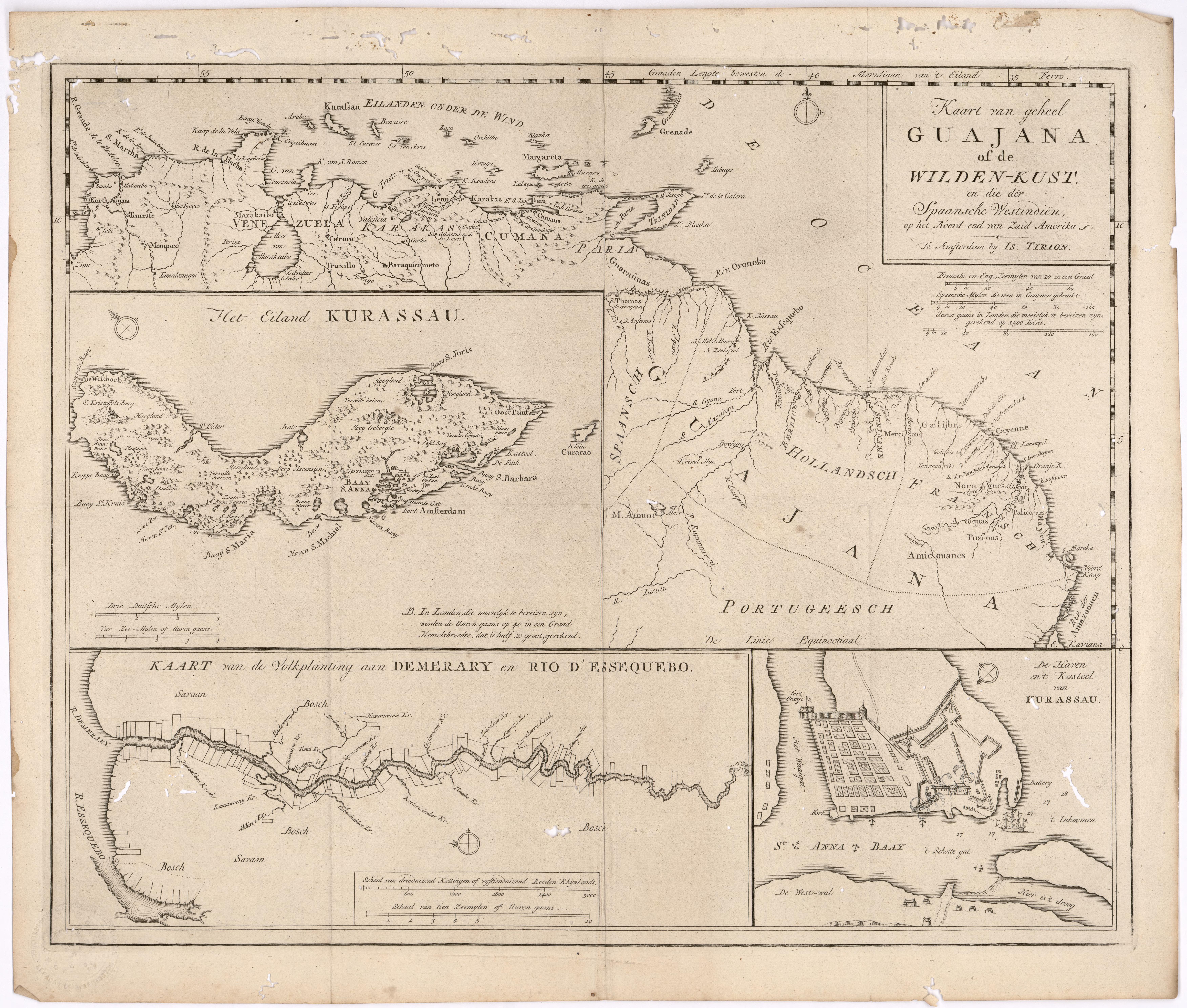
Dispossesions in the Americas

Dispossesions in the Americas

  • Lar
  • Explorar
  • Autores
  • Sobre
  • Arte
  • Corpos
  • Currículos
  • Patrimônio Cultural
  • Mapas
  • Territórios
Voltar à seção Explorar

Lendo em Inglês

Mapa 1700 - 1799

Kart van geheel Guajana of de Wilden-Kust

  • Tirion, Isaak

Publicado: 1720

  • Baixar Imagens
  • Baixar Imagens

Lendo em Espanhola

Mapa 1700 - 1799

Kart van geheel Guajana of de Wilden-Kust

  • Tirion, Isaak

Publicado: 1720

  • Baixar Imagens
  • Baixar Imagens
Mapa 1700 - 1799

Kart van geheel Guajana of de Wilden-Kust

  • Tirion, Isaak

Publicado: 1720

  • Baixar Imagens

Povos

  • ACOQUAS
  • AMICOUANES
  • GALIBIS
  • GUARAUNAS
  • MAYEZ
  • NORAGUES
  • PALICOURS
  • PIRIOUS

Citation

Tirion, Isaak. Map of the Whole of Guiana or the Savage Coast, and the Spanish West Indies at the Northern End of South America. Library of Congress. Accessed, August 3, 2023. https://www.loc.gov/resource/gdcwdl.wdl_11339/?r=0.213,0.044,0.861,0.453,0

  • Baixar Imagens

Itens Relacionados

Popoloca Towns

Popoloca Towns

Mapa 1950
The Tarahumar Country

The Tarahumar Country

Mapa 1600 - 1699
ECUADOR;NEW GRANADA;VENEZUELA;AND GUIANA.

ECUADOR;NEW GRANADA;VENEZUELA;AND GUIANA.

Mapa 1800 - 1899
"Carta Maritima del Reyno de Tierra Firme ú Castilla del Oro : Comprehende el Istmo y Provincia de Panamá, las Provincias de Veragua, Darien y Biruquete"

"Carta Maritima del Reyno de Tierra Firme ú Castilla del Oro : Comprehende el Istmo y Provincia de Panamá, las Provincias de Veragua, Darien y Biruquete"

Mapa 1729 - 1776
Carte 4: Le Pays Wayãpi : region Septentrionale

Carte 4: Le Pays Wayãpi : region Septentrionale

Mapa 1820 - 1860
PINTURA DE GUEGUETLAN

PINTURA DE GUEGUETLAN

Mapa 1500 - 1599
Preliminary Map;portion of north east [sic] Nicaragua: Brown's Camp to Pis Pis District.

Preliminary Map;portion of north east [sic] Nicaragua: Brown's Camp to Pis Pis District.

Mapa 1927
ORDENAMIENTO POLÍTICO DEL ESPACIO BAJO EL DOMINIO COLONIAL A FINALES DEL SIGLO XVI

ORDENAMIENTO POLÍTICO DEL ESPACIO BAJO EL DOMINIO COLONIAL A FINALES DEL SIGLO XVI

Mapa 1580

Desapropriações nas Américas

Um projeto de

University of Pennsylvania

Copyright 2024

Com o apoio de

Mellon Foundation

Projeto e desenvolvimento do site

Element 84

Créditos da arte

Tirion, Isaak. Map of the Whole of Guiana or the Savage Coast, and the Spanish West Indies at the Northern End of South America. Library of Congress. Accessed, August 3, 2023. https://www.loc.gov/resource/gdcwdl.wdl_11339/?r=0.213,0.044,0.861,0.453,0

Páginas do site

  • Lar
  • Explorar
  • Autores
  • Sobre
  • Arte
  • Corpos
  • Currículos
  • Patrimônio Cultural
  • Mapas
  • Territórios