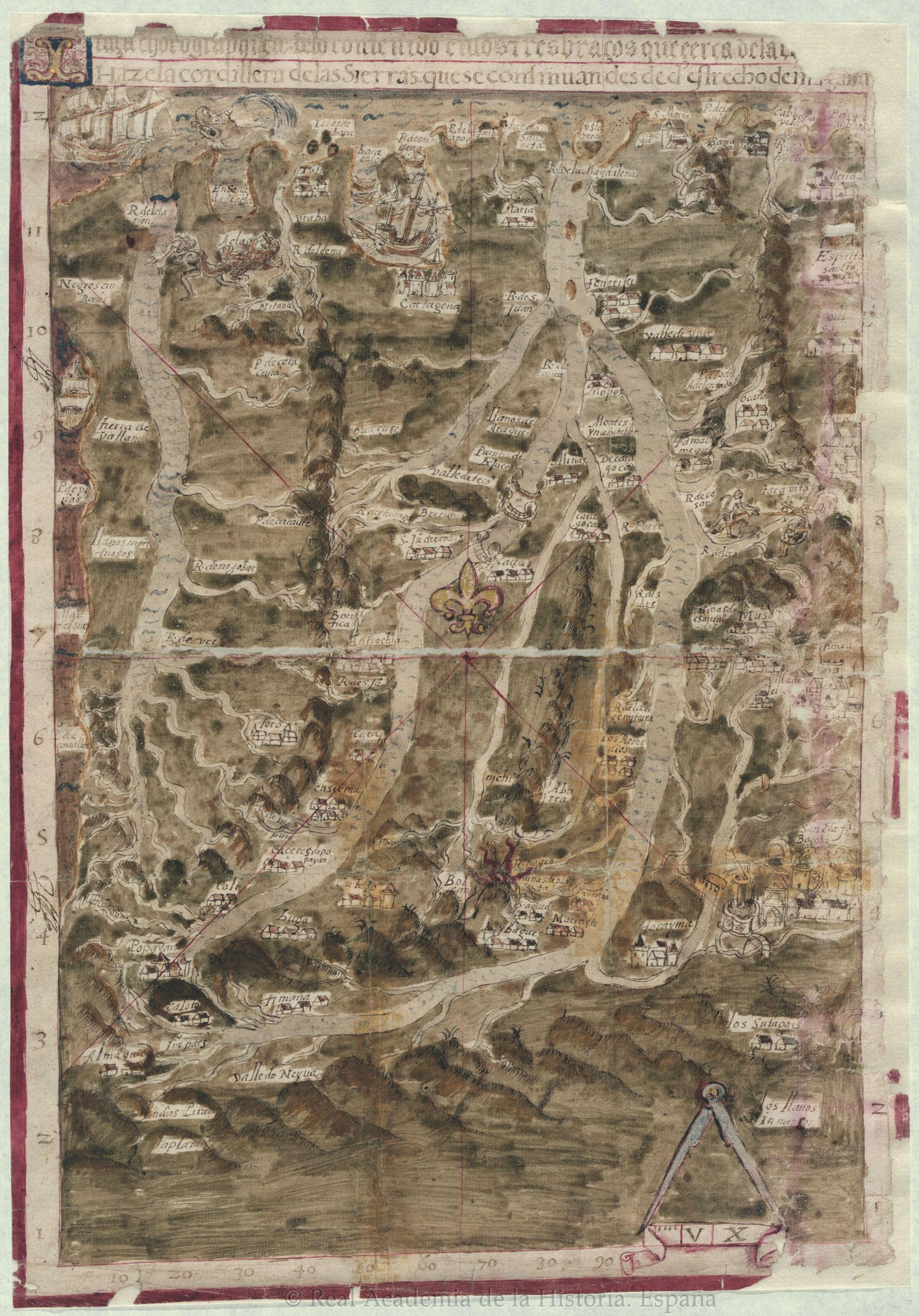
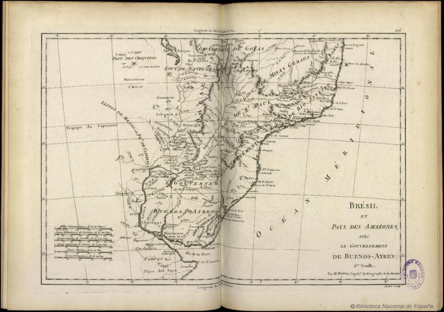
Dispossesions in the Americas

Dispossesions in the Americas

  • Lar
  • Explorar
  • Autores
  • Sobre
  • Arte
  • Corpos
  • Currículos
  • Patrimônio Cultural
  • Mapas
  • Territórios
Voltar à seção Explorar

Lendo em Inglês

Mapa 1788

Brésil et Pays des Amazones, avec le Gouvernement de Buenos-Ayres

  • BONNE, RIGOBERT

Publicado: 1788

  • Baixar Imagens
  • Baixar Imagens

Lendo em Espanhola

Mapa 1788

Brésil et Pays des Amazones, avec le Gouvernement de Buenos-Ayres

  • BONNE, RIGOBERT

Publicado: 1788

  • Baixar Imagens
  • Baixar Imagens
Mapa 1788

Brésil et Pays des Amazones, avec le Gouvernement de Buenos-Ayres

  • BONNE, RIGOBERT

Publicado: 1788

  • Baixar Imagens

Povos

  • MOROTOCOS
  • CAYAPOS
  • ITATIN
  • ZAMUCOS
  • LENGUAS
  • GUAYCURUS
  • PARAGUAS
  • ABIPONES
  • GUANANAS
  • TAPES
  • GUARANIS
  • GUANAS
  • BITURUNAS
  • CARIBES
  • GUANAS
  • BOANES
  • MINUANES
  • YAROS
  • CHARRUAS
  • CHECHEHETS

Citation

Bonne, Rigobert. "Brésil et Pays des Amazones, avec le Gouvernement de Buenos-Ayres." Map. In TitleAtlas Encyclopédique, contenant la Géographie Ancienne, et quelques cartes sur la Géographie du Moyen Age, la Geographie Moderne, et les Cartes Relatives á la Geographie Physique, by Rigobert Bonne and Nicolas Desmarest, 106. Vol. 2. Paris: Hôtel de Thou, 1788. Accessed July 11, 2023. http://bdh.bne.es/bnesearch/detalle/bdh0000000983.

  • Baixar Imagens

Itens Relacionados

Pueblos Taínos

Pueblos Taínos

Mapa 2000 - 2015
ATLAS DE LOS PUEBLOS INDÍGENAS DE MEXICO

ATLAS DE LOS PUEBLOS INDÍGENAS DE MEXICO

Mapa 2015
TERRITORIO DEL PUEBLO SHUAR ATRUAM

TERRITORIO DEL PUEBLO SHUAR ATRUAM

Mapa 2017
Traza corográfica de lo contenido dentro de los tres brazos que cerca de la Equinoccial hace la cordillera de las Sierras que se continúan desde el estrecho de Magallanes

Traza corográfica de lo contenido dentro de los tres brazos que cerca de la Equinoccial hace la cordillera de las Sierras que se continúan desde el estrecho de Magallanes

Mapa 1570
MAPA 1 LÍMITES GEOGRAFICOS DE LA LÍNEA NEGRA

MAPA 1 LÍMITES GEOGRAFICOS DE LA LÍNEA NEGRA

Mapa 2018
MAPA DE LA REPÚBLICA DEL PARAGUAY

MAPA DE LA REPÚBLICA DEL PARAGUAY

Mapa 1908
A Map of part of Yucatan or of that Part of the Eastern Shore Within the Bay of Honduras Alloted to Great Britain for the Cutting of Logwood, in consequence of the Convention Signed with Spain on the 14th July 1786.

A Map of part of Yucatan or of that Part of the Eastern Shore Within the Bay of Honduras Alloted to Great Britain for the Cutting of Logwood, in consequence of the Convention Signed with Spain on the 14th July 1786.

Mapa 1700
LOCALIDADES CON 40% Y MAS DE POBLACION INDIGENA Y TIPO DE MUNICIPIOS, MÉXICO, 2000

LOCALIDADES CON 40% Y MAS DE POBLACION INDIGENA Y TIPO DE MUNICIPIOS, MÉXICO, 2000

Mapa 2000

Desapropriações nas Américas

Um projeto de

University of Pennsylvania

Copyright 2024

Com o apoio de

Mellon Foundation

Projeto e desenvolvimento do site

Element 84

Créditos da arte

Bonne, Rigobert. “Brésil et Pays des Amazones, avec le Gouvernement de Buenos-Ayres.” Map. In TitleAtlas Encyclopédique, contenant la Géographie Ancienne, et quelques cartes sur la Géographie du Moyen Age, la Geographie Moderne, et les Cartes Relatives á la Geographie Physique, by Rigobert Bonne and Nicolas Desmarest, 106. Vol. 2. Paris: Hôtel de Thou, 1788. Accessed July 11, 2023. http://bdh.bne.es/bnesearch/detalle/bdh0000000983.

Páginas do site

  • Lar
  • Explorar
  • Autores
  • Sobre
  • Arte
  • Corpos
  • Currículos
  • Patrimônio Cultural
  • Mapas
  • Territórios