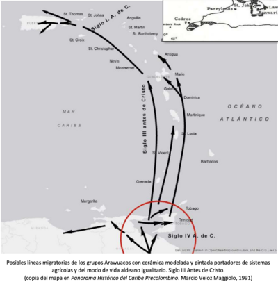
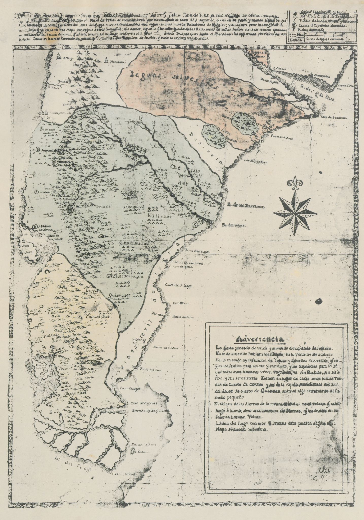
Dispossesions in the Americas

Dispossesions in the Americas

  • Lar
  • Explorar
  • Autores
  • Sobre
  • Arte
  • Corpos
  • Currículos
  • Patrimônio Cultural
  • Mapas
  • Territórios
Voltar à seção Explorar

Lendo em Inglês

Mapa 1700 - 1750

Carta inédita de la extremidad austral de América construída por el P. José Cardiel, S. J. en 1747

  • CARDIEL, JOSE

Publicado: 1747

  • Baixar Imagem
  • Baixar Imagem

Lendo em Espanhol

Mapa 1700 - 1750

Carta inédita de la extremidad austral de América construída por el P. José Cardiel, S. J. en 1747

  • CARDIEL, JOSE

Publicado: 1747

  • Baixar Imagem
  • Baixar Imagem
Mapa 1700 - 1750

Carta inédita de la extremidad austral de América construída por el P. José Cardiel, S. J. en 1747

  • CARDIEL, JOSE

Publicado: 1747

  • Baixar Imagem

Povos

  • POBLACION INFIEL
  • CHE CHE HET
  • EULICHET
  • UAIAUPI
  • TUCUMELEL
  • CHULILAUCHES
  • GEQUECHET
  • QUISUCHER
  • LOYUS
  • CHELEN
  • CHULILA
  • QUEYJU
  • SEHUAGNI
  • QUEYUANES

Citação

Cardiel, Jose, and Guillermo Furlong. Carta inédita de la extremidad austral de América construída por el P. José Cardiel, S. J. en 1747. Map. Buenos Aires, Argentina, 1747. Accessed July 9, 2023. https://digital.iai.spk-berlin.de/viewer/image/630121893/1/LOG_0000/.

  • Baixar Imagem

Itens Relacionados

COLOMBIA & GUAYANA

COLOMBIA & GUAYANA

Mapa 1800 - 1899
Fig. 1 Map of the Guianas with schematic locations of the
indigenous groups relevant to our study, based on the linguistic
map of South America (http://www.muturzikin.com/cartesamerique/
7.htm). Carib-speaking groups are indicated in yellow, Arawak-speaking
groups in blue, Tupi-speaking Wayãpi in pink and the Warao-speaking
group in green

Fig. 1 Map of the Guianas with schematic locations of the indigenous groups relevant to our study, based on the linguistic map of South America (http://www.muturzikin.com/cartesamerique/ 7.htm). Carib-speaking groups are indicated in yellow, Arawak-speaking groups in blue, Tupi-speaking Wayãpi in pink and the Warao-speaking group in green

Mapa 2000 - 2024
PROVINCIA DE SANTA CRUZ

PROVINCIA DE SANTA CRUZ

Mapa 1873
Da barra de Maranhao, ate a barra do Cuma sao tres legoas

Da barra de Maranhao, ate a barra do Cuma sao tres legoas

Mapa 1600 - 1640
PUEBLO IXCATECO

PUEBLO IXCATECO

Mapa 2020
Sketch map of part of RÍO ORINOCO and RIO CUCHIVERO from a survey by MAJOR STANLEY PATERSON

Sketch map of part of RÍO ORINOCO and RIO CUCHIVERO from a survey by MAJOR STANLEY PATERSON

Mapa 1896
Portada de la revista Trocha [Folha de rosto da revista Trocha]

Portada de la revista Trocha [Folha de rosto da revista Trocha]

Obra de arte
Posibles líneas migratorias de los grupos Arawuacos con cerámica modelada y pintada portadores de sistemas
agrícolas y del modo de vida aldeano igualitario. Siglo III Antes de Cristo.

Posibles líneas migratorias de los grupos Arawuacos con cerámica modelada y pintada portadores de sistemas agrícolas y del modo de vida aldeano igualitario. Siglo III Antes de Cristo.

Mapa -400 - -100

Despossessões nas Américas

Um projeto de

University of Pennsylvania

Copyright 2024

Com o apoio de

Mellon Foundation

Projeto e desenvolvimento do site

Element 84

Créditos da arte

Cardiel, Jose, and Guillermo Furlong. Carta inédita de la extremidad austral de América construída por el P. José Cardiel, S. J. en 1747. Map. Buenos Aires, Argentina, 1747. Accessed July 9, 2023. https://digital.iai.spk-berlin.de/viewer/image/630121893/1/LOG_0000/.

Páginas do site

  • Lar
  • Explorar
  • Autores
  • Sobre
  • Arte
  • Corpos
  • Currículos
  • Patrimônio Cultural
  • Mapas
  • Territórios