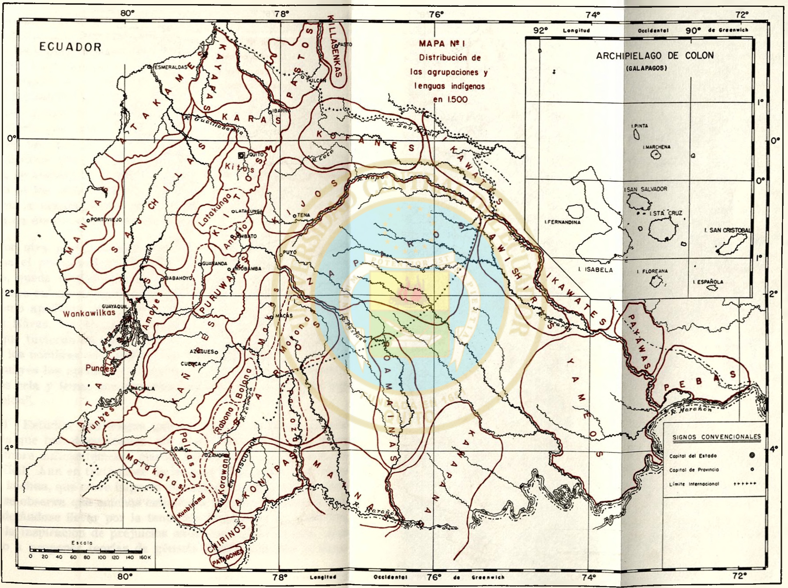
Dispossesions in the Americas

Dispossesions in the Americas

  • Lar
  • Explorar
  • Autores
  • Sobre
  • Arte
  • Corpos
  • Currículos
  • Patrimônio Cultural
  • Mapas
  • Territórios
Voltar à seção Explorar

Lendo em Inglês

Mapa 1800 - 1899

Guyanes. Amér. Mérid. no. 7. (Dresse par Ph. Vandermaelen, lithographie par H. Ode. Cinquième partie. - Amer. merid. Bruxelles. 1827)

  • Vandermaelen, Philippe

Publicado: 1827

  • Baixar Imagens
  • Baixar Imagens

Lendo em Espanhola

Mapa 1800 - 1899

Guyanes. Amér. Mérid. no. 7. (Dresse par Ph. Vandermaelen, lithographie par H. Ode. Cinquième partie. - Amer. merid. Bruxelles. 1827)

  • Vandermaelen, Philippe

Publicado: 1827

  • Baixar Imagens
  • Baixar Imagens
Mapa 1800 - 1899

Guyanes. Amér. Mérid. no. 7. (Dresse par Ph. Vandermaelen, lithographie par H. Ode. Cinquième partie. - Amer. merid. Bruxelles. 1827)

  • Vandermaelen, Philippe

Publicado: 1827

  • Baixar Imagens

Povos

  • ACOQUAS
  • AMICOUANES
  • ARMABOUTOUS
  • CARPINAS
  • COUSSARIS
  • GALIBIS
  • GUACAMAYAS
  • KIRIKIRISCOTAS
  • MACUSIS
  • MAYEZ
  • MERILLANS
  • PARABAYANAS
  • PALICOURS
  • PIRIOUS
  • TOUNOYENES

Citation

Vandermaelen, Philippe, Guyanes. Amer. Merid. 7. David Rumsey Map Collection. Accessed: July 4, 2023. https://www.davidrumsey.com/luna/servlet/detail/RUMSEY~8~1~25246~5500106:Guyanes--Amer--Merid--7-

  • Baixar Imagens

Itens Relacionados

Mapa de Magallanes

Mapa de Magallanes

Mapa 1746
A chart of the English trading part of the bay of Honduras

A chart of the English trading part of the bay of Honduras

Mapa 1791
Distribución  de  los  Grupos  Indígenas  de Bolivia

Distribución de los Grupos Indígenas de Bolivia

Mapa 2000 - 2010
Mapa de la villa de San Juan de los Remedios de el Cayo y sus contornos

Mapa de la villa de San Juan de los Remedios de el Cayo y sus contornos

Mapa 1600 - 1699
MAPA N. 1 DISTRIBUCIÓN DE LAS AGRUPACIONES Y LENGUAS INDÍGENAS EN 1500

MAPA N. 1 DISTRIBUCIÓN DE LAS AGRUPACIONES Y LENGUAS INDÍGENAS EN 1500

Mapa 1500
PUEBLO MASTANAHUA

PUEBLO MASTANAHUA

Mapa 2021
TERRITORIO DE YUKPA DE PERIJA

TERRITORIO DE YUKPA DE PERIJA

Mapa 2018
PROVINCIA DO MARANHAO

PROVINCIA DO MARANHAO

Mapa 1800 - 1850

Desapropriações nas Américas

Um projeto de

University of Pennsylvania

Copyright 2024

Com o apoio de

Mellon Foundation

Projeto e desenvolvimento do site

Element 84

Créditos da arte

Vandermaelen, Philippe, Guyanes. Amer. Merid. 7. David Rumsey Map Collection. Accessed: July 4, 2023. https://www.davidrumsey.com/luna/servlet/detail/RUMSEY~8~1~25246~5500106:Guyanes--Amer--Merid--7-

Páginas do site

  • Lar
  • Explorar
  • Autores
  • Sobre
  • Arte
  • Corpos
  • Currículos
  • Patrimônio Cultural
  • Mapas
  • Territórios