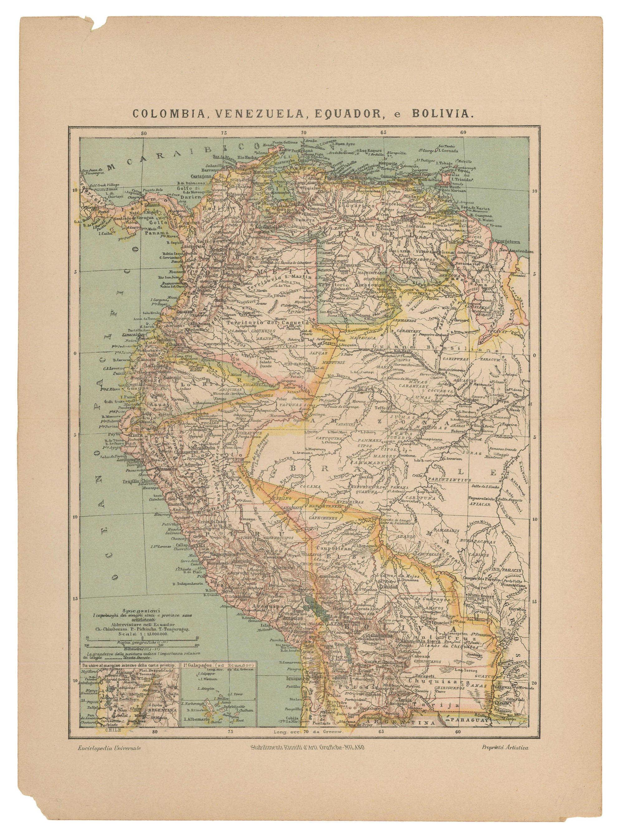
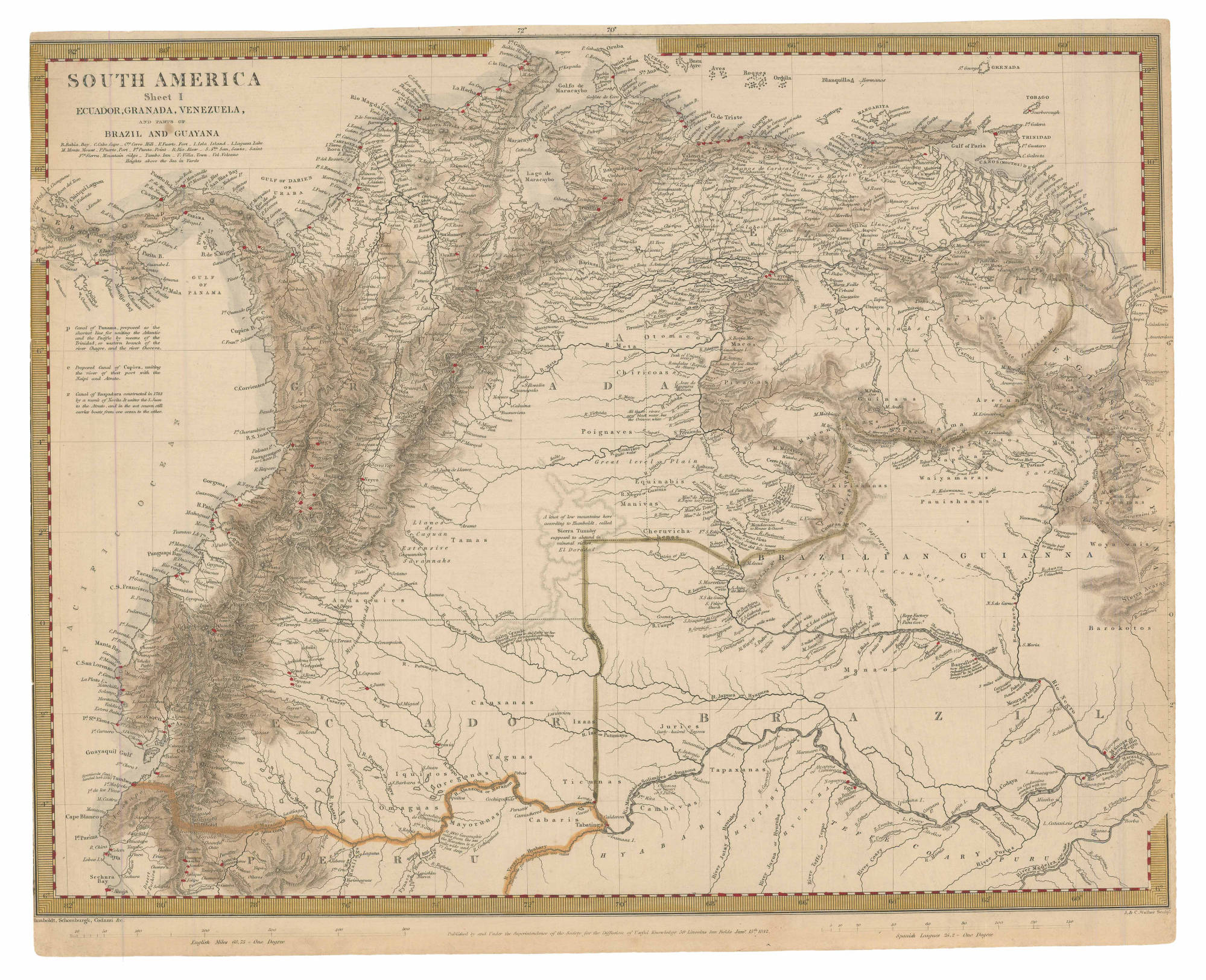
Dispossesions in the Americas

Dispossesions in the Americas

  • Lar
  • Explorar
  • Autores
  • Sobre
  • Arte
  • Corpos
  • Currículos
  • Patrimônio Cultural
  • Mapas
  • Territórios
Voltar à seção Explorar

Lendo em Inglês

Mapa 1842

SOUTH AMERICA Sheet I: ECUADOR;GRANADA;VENEZUELA;AND PARTS OF BRAZIL AND GUYANA

  • HUMBOLDT;ALEXANDER;ET AL.

Publicado: 1842

  • Baixar Imagens
  • Baixar Imagens

Lendo em Espanhola

Mapa 1842

SOUTH AMERICA Sheet I: ECUADOR;GRANADA;VENEZUELA;AND PARTS OF BRAZIL AND GUYANA

  • HUMBOLDT;ALEXANDER;ET AL.

Publicado: 1842

  • Baixar Imagens
  • Baixar Imagens
Mapa 1842

SOUTH AMERICA Sheet I: ECUADOR;GRANADA;VENEZUELA;AND PARTS OF BRAZIL AND GUYANA

  • HUMBOLDT;ALEXANDER;ET AL.

Publicado: 1842

  • Baixar Imagens

Povos

  • GUARUANA
  • CARIBE
  • MACOS
  • OTOMACO
  • PUINAVE
  • CHIRICOA
  • PIAROA
  • MAIONGEONG
  • GUINAUS
  • ARECUNAS
  • MAKUSHI
  • PURIGOTOS
  • ZAPARA
  • KIRISHANA
  • EQUINABIS
  • MANIVAS
  • CHURUVICHAGENA
  • PAUISHANAS
  • WAIYAMARAS
  • ANDAQUIES
  • TAMAS
  • WOYAWAIS
  • BAROKOTOS
  • MANAOS
  • CAUXANAS
  • IQUITOS
  • OREGONOS
  • YAGUAS
  • TICUNAS
  • JURIES
  • TAPAXANAS
  • CAMBEVAS
  • CABARIS
  • MAYORUNAS
  • OMAGUAS

Citation

Humboldt, Alexander Barón von, P & S Potter, and Agustín Codazzi. South América sheet I: Ecuador, Granada, Venezuela, and parts of Brazil and Guyana. Map. London: Society for the Diffusion of Useful Knowledge, 1842. Accessed February 4, 2023. https://babel.banrepcultural.org/digital/collection/p17054coll13/id/388/rec/31.

  • Baixar Imagens

Itens Relacionados

COLOMBIA;VENEZUELA;EQUADOR e BOLIVIA

COLOMBIA;VENEZUELA;EQUADOR e BOLIVIA

Mapa 1900 - 1999
Detail from the 1770 copy of Francisco Álvarez Barreiro’s 1728 map of northern New Spain illustrating Spanish mapping of Indian domains in southern Texas and along the Gulf Coast, especially through the repetition of labels: “tierra de los Pampopas,” “tierra de los Carrizos,” “tierra de los Cujanes,” etc.

Detail from the 1770 copy of Francisco Álvarez Barreiro’s 1728 map of northern New Spain illustrating Spanish mapping of Indian domains in southern Texas and along the Gulf Coast, especially through the repetition of labels: “tierra de los Pampopas,” “tierra de los Carrizos,” “tierra de los Cujanes,” etc.

Mapa 1728
PUEBLO CHICHIMECA JONAZ

PUEBLO CHICHIMECA JONAZ

Mapa 2020
Chili

Chili

Mapa 1625
"Territorio Indígena Abrojo Montezuma (Ngöbes)"

"Territorio Indígena Abrojo Montezuma (Ngöbes)"

Mapa 2010
The coast of Tierra Firma from Cartagena to Golfo Triste

The coast of Tierra Firma from Cartagena to Golfo Triste

Mapa 1775
MANJUI

MANJUI

Mapa 2015
Qom-lik

Qom-lik

Mapa 2001

Desapropriações nas Américas

Um projeto de

University of Pennsylvania

Copyright 2024

Com o apoio de

Mellon Foundation

Projeto e desenvolvimento do site

Element 84

Créditos da arte

Humboldt, Alexander Barón von, P & S Potter, and Agustín Codazzi. South América sheet I: Ecuador, Granada, Venezuela, and parts of Brazil and Guyana. Map. London: Society for the Diffusion of Useful Knowledge, 1842. Accessed February 4, 2023. https://babel.banrepcultural.org/digital/collection/p17054coll13/id/388/rec/31.

Páginas do site

  • Lar
  • Explorar
  • Autores
  • Sobre
  • Arte
  • Corpos
  • Currículos
  • Patrimônio Cultural
  • Mapas
  • Territórios