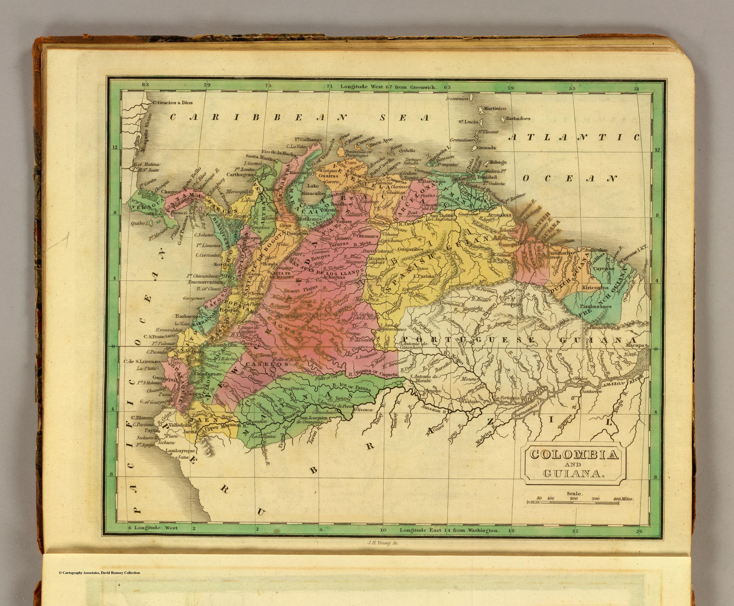
Dispossesions in the Americas

Dispossesions in the Americas

  • Lar
  • Explorar
  • Autores
  • Sobre
  • Arte
  • Corpos
  • Currículos
  • Patrimônio Cultural
  • Mapas
  • Territórios
Voltar à seção Explorar

Lendo em Inglês

Mapa 1858

H. KIEPERT'S KARTE DES NORDLICHEN TROPISCHEN AMERICA

  • KIEPERT;HEINRICH;ET AL.

Publicado: 1858

  • Baixar Imagem
  • Baixar Imagem

Lendo em Espanhol

Mapa 1858

H. KIEPERT'S KARTE DES NORDLICHEN TROPISCHEN AMERICA

  • KIEPERT;HEINRICH;ET AL.

Publicado: 1858

  • Baixar Imagem
  • Baixar Imagem
Mapa 1858

H. KIEPERT'S KARTE DES NORDLICHEN TROPISCHEN AMERICA

  • KIEPERT;HEINRICH;ET AL.

Publicado: 1858

  • Baixar Imagem

Povos

  • GUAJIRA
  • GUARAUNOS
  • WARRAU
  • AGUARICOTOS
  • PANARAS
  • QUIRIQUIRIPOS
  • CAMARACOTOS
  • WAIKAS
  • SEREKONG
  • BARINAGOTOS
  • MAPOJOS
  • TAPARITOS
  • PARABENAS
  • CADUPINAPOS
  • ARINAGOTOS
  • AYANOS
  • INAOS
  • CURACHICANAS
  • GUAIQUIRES
  • PARECAS
  • MACOS
  • PIAROAS
  • GUAHIBOS
  • AMORUAS
  • GUAIPUNAVOS
  • MAQUIRITARE
  • MAYONGKONG
  • YOCURAS
  • AVERIANOS
  • GUAINARES
  • GUAHARIBOS
  • PURUCOTOS
  • QUIRIXANA
  • PURIGOTOS
  • GUINAUS
  • MAUITSIS
  • ZAPARAS
  • ARECUNAS
  • MACUSIS
  • CARIBES
  • GUACABAYAS
  • MAROONS
  • PIANOGHOTTOS
  • WOYAWAIS
  • TARUMAS
  • ATORAIS
  • WAPISIANAS
  • PAUIXANAS
  • CURIARANAS
  • CUNIPASANAS
  • YABANOS
  • CHERUVICHAHENAS
  • MACUENIS
  • AZANENIS

Citação

Kiepert, Heinrich. H. Kiepert's Karte des nordlichen Tropischen America. Map. Berlin: Deitrich Reimer, 1858. Accessed October 2, 2022. https://www.davidrumsey.com/luna/servlet/detail/RUMSEY~8~1~3623~330003:H--Kiepert-s-Karte-des-nordlichen-T?sort=pub_list_no_initialsort%2Cpub_date%2Cpub_list_no%2Cseries_no#.

  • Baixar Imagem

Itens Relacionados

COLOMBIA AND GUIANA

COLOMBIA AND GUIANA

Mapa 1830
Carte de l'entrée de la Rivière de Kourou.

Carte de l'entrée de la Rivière de Kourou.

Mapa 1764
South America: From the latest Discoveries, Shewing the Spanish and Portuguese Settlements, according to Mr. D'Anville.

South America: From the latest Discoveries, Shewing the Spanish and Portuguese Settlements, according to Mr. D'Anville.

Mapa 1771
The Southern Maya Lowlands during the Sixteenth and Seventeenth Centuries

The Southern Maya Lowlands during the Sixteenth and Seventeenth Centuries

Mapa 1500 - 1700
Angaité

Angaité

Mapa 2001
MAPA QUE COMPRENDE TODO EL DISTRITO DE LA AUDIENCIA DE QUITO

MAPA QUE COMPRENDE TODO EL DISTRITO DE LA AUDIENCIA DE QUITO

Mapa 1779
South America from the latest discoveries, shewing the Spanish & Portuguese settlements according to Mr. D'Anville

South America from the latest discoveries, shewing the Spanish & Portuguese settlements according to Mr. D'Anville

Mapa 1771
Paraguay;ó prov. de Rio de la Plata cum regionibus adiacentibus Tucuman et Sta. Cruz de la Sierra

Paraguay;ó prov. de Rio de la Plata cum regionibus adiacentibus Tucuman et Sta. Cruz de la Sierra

Mapa 1600 - 1699

Despossessões nas Américas

Um projeto de

University of Pennsylvania

Copyright 2024

Com o apoio de

Mellon Foundation

Projeto e desenvolvimento do site

Element 84

Créditos da arte

Kiepert, Heinrich. H. Kiepert’s Karte des nordlichen Tropischen America. Map. Berlin: Deitrich Reimer, 1858. Accessed October 2, 2022. https://www.davidrumsey.com/luna/servlet/detail/RUMSEY~8~1~3623~330003:H--Kiepert-s-Karte-des-nordlichen-T?sort=pub_list_no_initialsort%2Cpub_date%2Cpub_list_no%2Cseries_no#.

Páginas do site

  • Lar
  • Explorar
  • Autores
  • Sobre
  • Arte
  • Corpos
  • Currículos
  • Patrimônio Cultural
  • Mapas
  • Territórios