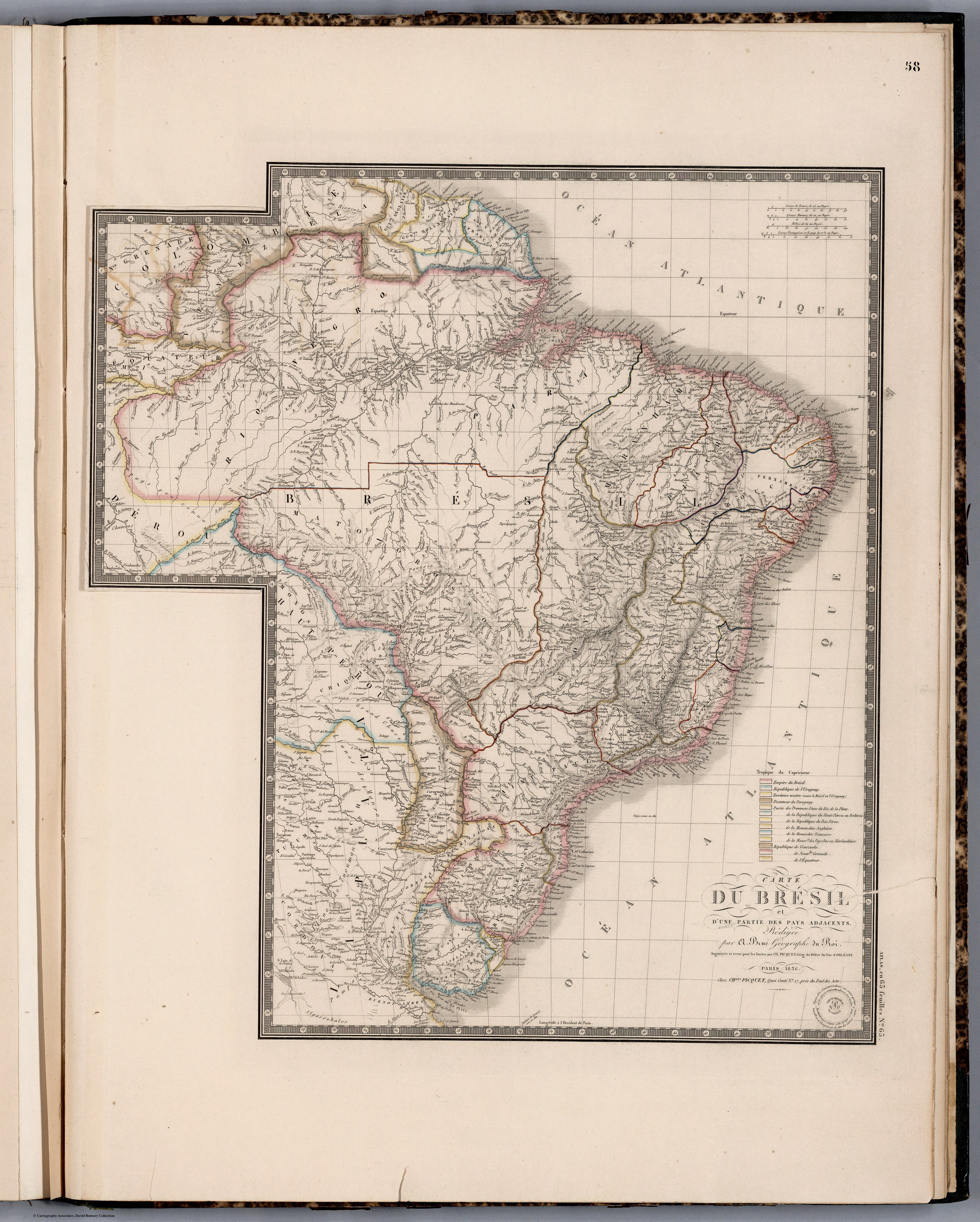
Dispossesions in the Americas

Dispossesions in the Americas

  • Lar
  • Explorar
  • Autores
  • Sobre
  • Arte
  • Corpos
  • Currículos
  • Patrimônio Cultural
  • Mapas
  • Territórios
Voltar à seção Explorar

Lendo em Inglês

Mapa 1836

CARTE DU BRÉSIL

  • PICQUET;CHLES;ET AL.

Publicado: 1854

  • Baixar Imagem
  • Baixar Imagem

Lendo em Espanhol

Mapa 1836

CARTE DU BRÉSIL

  • PICQUET;CHLES;ET AL.

Publicado: 1854

  • Baixar Imagem
  • Baixar Imagem
Mapa 1836

CARTE DU BRÉSIL

  • PICQUET;CHLES;ET AL.

Publicado: 1854

  • Baixar Imagem

Povos

  • GALIBIS
  • EMERILLONS
  • OYAMPIS
  • MANAOS
  • TAPIRAPEQUES
  • MUNDRUCUS
  • PARESIS
  • BOROROS
  • PEREGUANOS
  • CURROYENOS
  • CHORARACUS
  • CHIRIVONES
  • IBITAYAS
  • IGARONES
  • CAMACULAS
  • AYUQUILITERAS
  • AGUSE
  • BOYAUNAS
  • GUAROCANOS
  • CHIQUINOS
  • AGUAYES
  • OJOTUTAS
  • TOBETIONOS
  • MONGOLAS
  • TAPES
  • TRACANOS
  • ABIPONES

Citação

Picquet, Chles, and Brue. Carte du Bresil. Map. Chez J. Andriveau-Goujon, 1836. Accessed April 30, 2022. https://www.davidrumsey.com/luna/servlet/detail/RUMSEY~8~1~284532~90057074:Carte-du-Bresil-?sort=pub_list_no_initialsort%2Cpub_list_no_initialsort%2Cpub_date%2Cpub_date&qvq=w4s:/where%2FURU,sort:pub_list_no_initialsort%2Cpub_list_no_initialsort%2Cpub_date%2Cpub_date,lc:RUMSEY~8~1&mi=36&trs=95.

  • Baixar Imagem

Itens Relacionados

CARTA del CANTON de CAYCARA de la Provincia de Guayana

CARTA del CANTON de CAYCARA de la Provincia de Guayana

Mapa 1840
Serie Fatherland / Padre Patria [Série Fatherland / Pai pátria]

Serie Fatherland / Padre Patria [Série Fatherland / Pai pátria]

Obra de arte
Popoloca Towns

Popoloca Towns

Mapa 1950
El mundo entero está mirando: Todas las mujeres son bienvenidas [O mundo inteiro está olhando: Todas as mulheres são bem-vindas]

El mundo entero está mirando: Todas las mujeres son bienvenidas [O mundo inteiro está olhando: Todas as mulheres são bem-vindas]

Obra de arte
Plano de la Yntendencia del Cuzco. Hecho de orden del Exmo. Sor.  Virrey Fr. Franco. Gil y Lemos, año de 1792

Plano de la Yntendencia del Cuzco. Hecho de orden del Exmo. Sor. Virrey Fr. Franco. Gil y Lemos, año de 1792

Mapa 1792
Grupo aborigen Emberá

Grupo aborigen Emberá

Mapa
CARTA ETNOGRÁFICA DE MEXICO

CARTA ETNOGRÁFICA DE MEXICO

Mapa 1864
La región litoral ecuatoriana

La región litoral ecuatoriana

Mapa -500 - 1551

Despossessões nas Américas

Um projeto de

University of Pennsylvania

Copyright 2024

Com o apoio de

Mellon Foundation

Projeto e desenvolvimento do site

Element 84

Créditos da arte

Picquet, Chles, and Brue. Carte du Bresil. Map. Chez J. Andriveau-Goujon, 1836. Accessed April 30, 2022. https://www.davidrumsey.com/luna/servlet/detail/RUMSEY~8~1~284532~90057074:Carte-du-Bresil-?sort=pub_list_no_initialsort%2Cpub_list_no_initialsort%2Cpub_date%2Cpub_date&qvq=w4s:/where%2FURU,sort:pub_list_no_initialsort%2Cpub_list_no_initialsort%2Cpub_date%2Cpub_date,lc:RUMSEY~8~1&mi=36&trs=95.

Páginas do site

  • Lar
  • Explorar
  • Autores
  • Sobre
  • Arte
  • Corpos
  • Currículos
  • Patrimônio Cultural
  • Mapas
  • Territórios