Dispossesions in the Americas

Dispossesions in the Americas

  • Lar
  • Explorar
  • Autores
  • Sobre
  • Arte
  • Corpos
  • Currículos
  • Patrimônio Cultural
  • Mapas
  • Territórios
Voltar à seção Explorar

Lendo em Inglês

Mapa 1911 - 1952

Map of Mapuche Land Dispossession for Chilean and German Settlers

  • Molina, Raul

Publicado: 1990

  • Baixar Imagens
  • Baixar Imagens

Lendo em Espanhola

Mapa 1911 - 1952

Map of Mapuche Land Dispossession for Chilean and German Settlers

  • Molina, Raul

Publicado: 1990

  • Baixar Imagens
  • Baixar Imagens
Mapa 1911 - 1952

Map of Mapuche Land Dispossession for Chilean and German Settlers

  • Molina, Raul

Publicado: 1990

  • Baixar Imagens

Povos

  • MAPUCHE

Citation

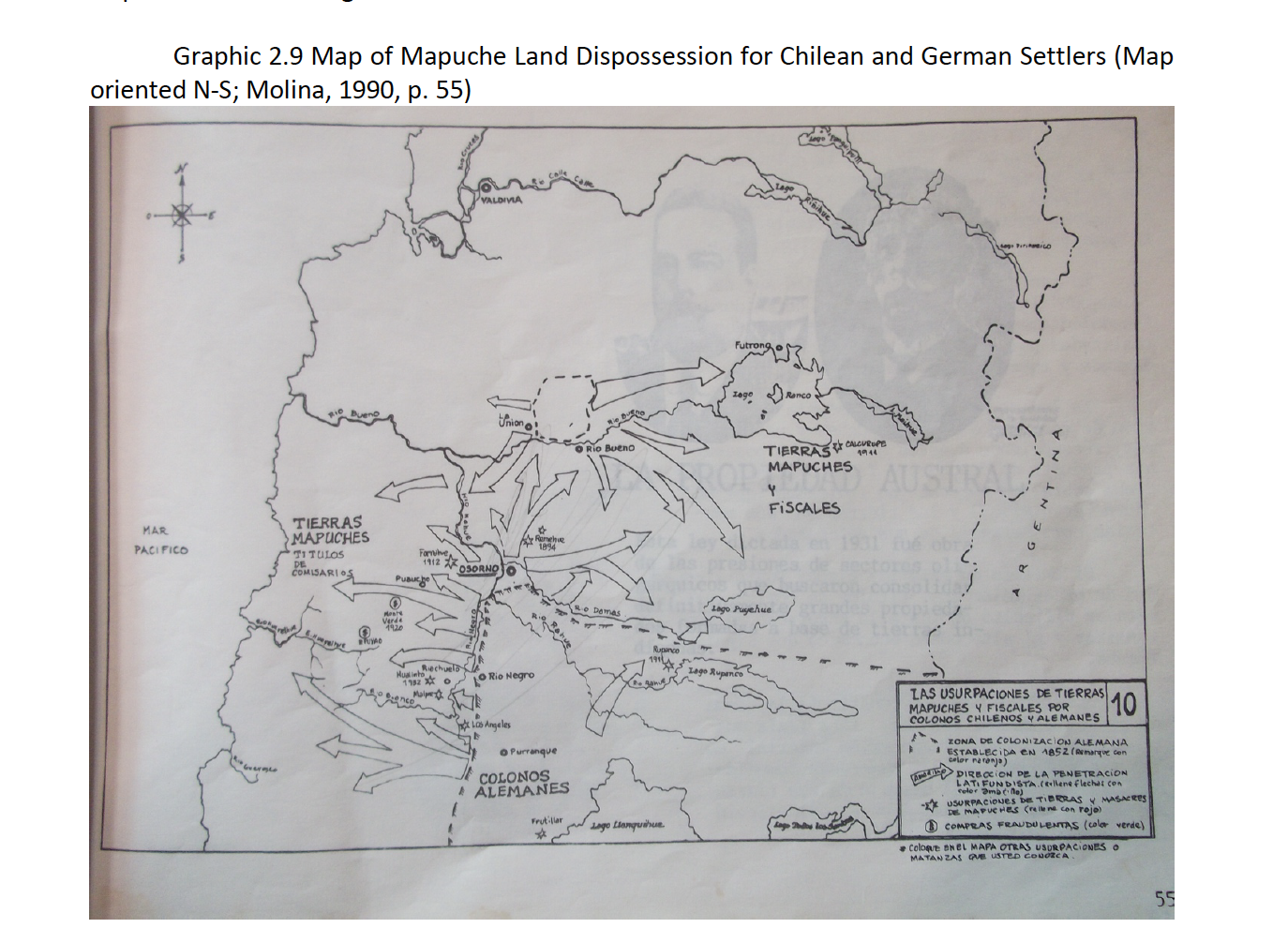
Molina, Raul. "Map of Mapuche Land Dispossession for Chilean and German Settlers." Map. In ARTICULATING INDIGENOUS RIGHTS AMIDST TERRITORIAL FRAGMENTATION: SMALL HYDROPOWER CONFLICTS IN THE PUELWILLIMAPU, SOUTHER CHILE, by Sarah Kelly, 53. N.p.: University of Arizona, 2018. https://ui.adsabs.harvard.edu/abs/2018PhDT........81K/abstract

  • Baixar Imagens

Itens Relacionados

Carte de la Partie de l'Ocean

Carte de la Partie de l'Ocean

Mapa 1737
Fig. 1 Map of the Guianas with schematic locations of the
indigenous groups relevant to our study, based on the linguistic
map of South America (http://www.muturzikin.com/cartesamerique/
7.htm). Carib-speaking groups are indicated in yellow, Arawak-speaking
groups in blue, Tupi-speaking Wayãpi in pink and the Warao-speaking
group in green

Fig. 1 Map of the Guianas with schematic locations of the indigenous groups relevant to our study, based on the linguistic map of South America (http://www.muturzikin.com/cartesamerique/ 7.htm). Carib-speaking groups are indicated in yellow, Arawak-speaking groups in blue, Tupi-speaking Wayãpi in pink and the Warao-speaking group in green

Mapa 2000 - 2024
El manifiesto PrEP [O manifesto PrEP]

El manifiesto PrEP [O manifesto PrEP]

Obra de arte
La Mirada Bizca [O Olhar Vesgo]

La Mirada Bizca [O Olhar Vesgo]

Obra de arte
Indian Creek

Indian Creek

Mapa 1997
Amérique méridionale publiée sous les auspices de Monseigneur le Duc d'Orleans

Amérique méridionale publiée sous les auspices de Monseigneur le Duc d'Orleans

Mapa 1748
Descripción geográfica (mapa que comprehende la visita practicada por el Sr. Doctor Don Francisco Antonio Moreno y Escandon;Fiscal del Crimen en la Real Audiencia de Santa Fé de Bogotá. 1781 A consequencia de Real Cédula fecha á tres de Agosto de 1774

Descripción geográfica (mapa que comprehende la visita practicada por el Sr. Doctor Don Francisco Antonio Moreno y Escandon;Fiscal del Crimen en la Real Audiencia de Santa Fé de Bogotá. 1781 A consequencia de Real Cédula fecha á tres de Agosto de 1774

Mapa 1781
MICHOACÁN

MICHOACÁN

Mapa 2015

Desapropriações nas Américas

Um projeto de

University of Pennsylvania

Copyright 2024

Com o apoio de

Mellon Foundation

Projeto e desenvolvimento do site

Element 84

Créditos da arte

Molina, Raul. “Map of Mapuche Land Dispossession for Chilean and German Settlers.” Map. In ARTICULATING INDIGENOUS RIGHTS AMIDST TERRITORIAL FRAGMENTATION: SMALL HYDROPOWER CONFLICTS IN THE PUELWILLIMAPU, SOUTHER CHILE, by Sarah Kelly, 53. N.p.: University of Arizona, 2018. https://ui.adsabs.harvard.edu/abs/2018PhDT........81K/abstract

Páginas do site

  • Lar
  • Explorar
  • Autores
  • Sobre
  • Arte
  • Corpos
  • Currículos
  • Patrimônio Cultural
  • Mapas
  • Territórios