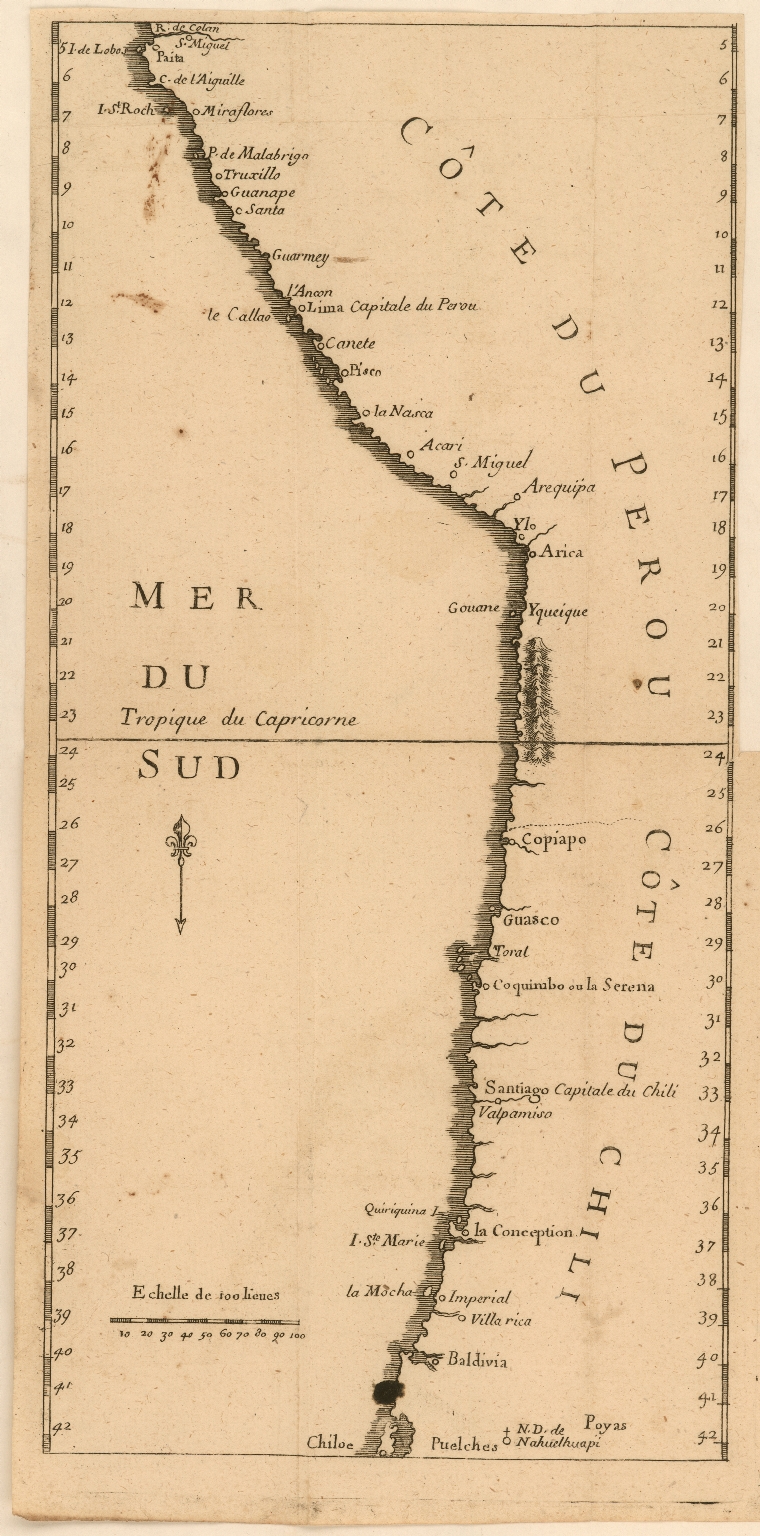
Dispossesions in the Americas

Dispossesions in the Americas

  • Lar
  • Explorar
  • Autores
  • Sobre
  • Arte
  • Corpos
  • Currículos
  • Patrimônio Cultural
  • Mapas
  • Territórios
Voltar à seção Explorar

Lendo em Inglês

Mapa 1707

Côte du Perou

  • Jesuits

Publicado: 1707

  • Baixar Imagens
  • Baixar Imagens

Lendo em Espanhola

Mapa 1707

Côte du Perou

  • Jesuits

Publicado: 1707

  • Baixar Imagens
  • Baixar Imagens
Mapa 1707

Côte du Perou

  • Jesuits

Publicado: 1707

  • Baixar Imagens

Povos

  • PUELCHES
  • POYAS

Citation

Jesuits. "Côte du Perou." Map. 1707. Accessed March 10, 2022. https://jcb.lunaimaging.com/luna/servlet/detail/JCBMAPS~1~1~6170~115902293:C%C3%B4te-du-Perou?sort=normalized_date%2Cfile_name%2Csource_author%2Csource_title#

  • Baixar Imagens

Itens Relacionados

PUEBLO SERI

PUEBLO SERI

Mapa 2020
Outlines of the physical and political division of South America: Delineated by A. Arrowsmith partly from scarce and original documents, published before the year 1806 but principally from manuscript maps & surveys made between the years 1771 and 1806, corrected from accurate astronomical observations to 1810.

Outlines of the physical and political division of South America: Delineated by A. Arrowsmith partly from scarce and original documents, published before the year 1806 but principally from manuscript maps & surveys made between the years 1771 and 1806, corrected from accurate astronomical observations to 1810.

Mapa 1800 - 1899
Guyana

Guyana

Mapa 1800 - 1899
The indigenous language groups  of Baja California at contact

The indigenous language groups of Baja California at contact

Mapa 1530
Nicaragua

Nicaragua

Mapa 1900 - 1903
BORRADOR TOPOGRÁFICO DE LA LÍNEA DIVISORIA, QUE CITA EL ARTÍCULO 12º DEL TRATADO PRELIMINAR, Y AJUSTADAS DISTANCIAS HASTA SU PUNTO FINAL

BORRADOR TOPOGRÁFICO DE LA LÍNEA DIVISORIA, QUE CITA EL ARTÍCULO 12º DEL TRATADO PRELIMINAR, Y AJUSTADAS DISTANCIAS HASTA SU PUNTO FINAL

Mapa 1800 - 1850
The Bosawa Reserve and Indigenous Territories;Nicaragua.

The Bosawa Reserve and Indigenous Territories;Nicaragua.

Mapa 2000 - 2003
Povo Walimanai [Baniwa] Aldeia São Joaquim, Rio Ayari, território Indígena Alto Rio Negro, AM (Amazonas), Brasil Placa

Povo Walimanai [Baniwa] Aldeia São Joaquim, Rio Ayari, território Indígena Alto Rio Negro, AM (Amazonas), Brasil Placa

Obra de arte

Desapropriações nas Américas

Um projeto de

University of Pennsylvania

Copyright 2024

Com o apoio de

Mellon Foundation

Projeto e desenvolvimento do site

Element 84

Créditos da arte

Jesuits. “Côte du Perou.” Map. 1707. Accessed March 10, 2022. https://jcb.lunaimaging.com/luna/servlet/detail/JCBMAPS~1~1~6170~115902293:C%C3%B4te-du-Perou?sort=normalized_date%2Cfile_name%2Csource_author%2Csource_title#

Páginas do site

  • Lar
  • Explorar
  • Autores
  • Sobre
  • Arte
  • Corpos
  • Currículos
  • Patrimônio Cultural
  • Mapas
  • Territórios