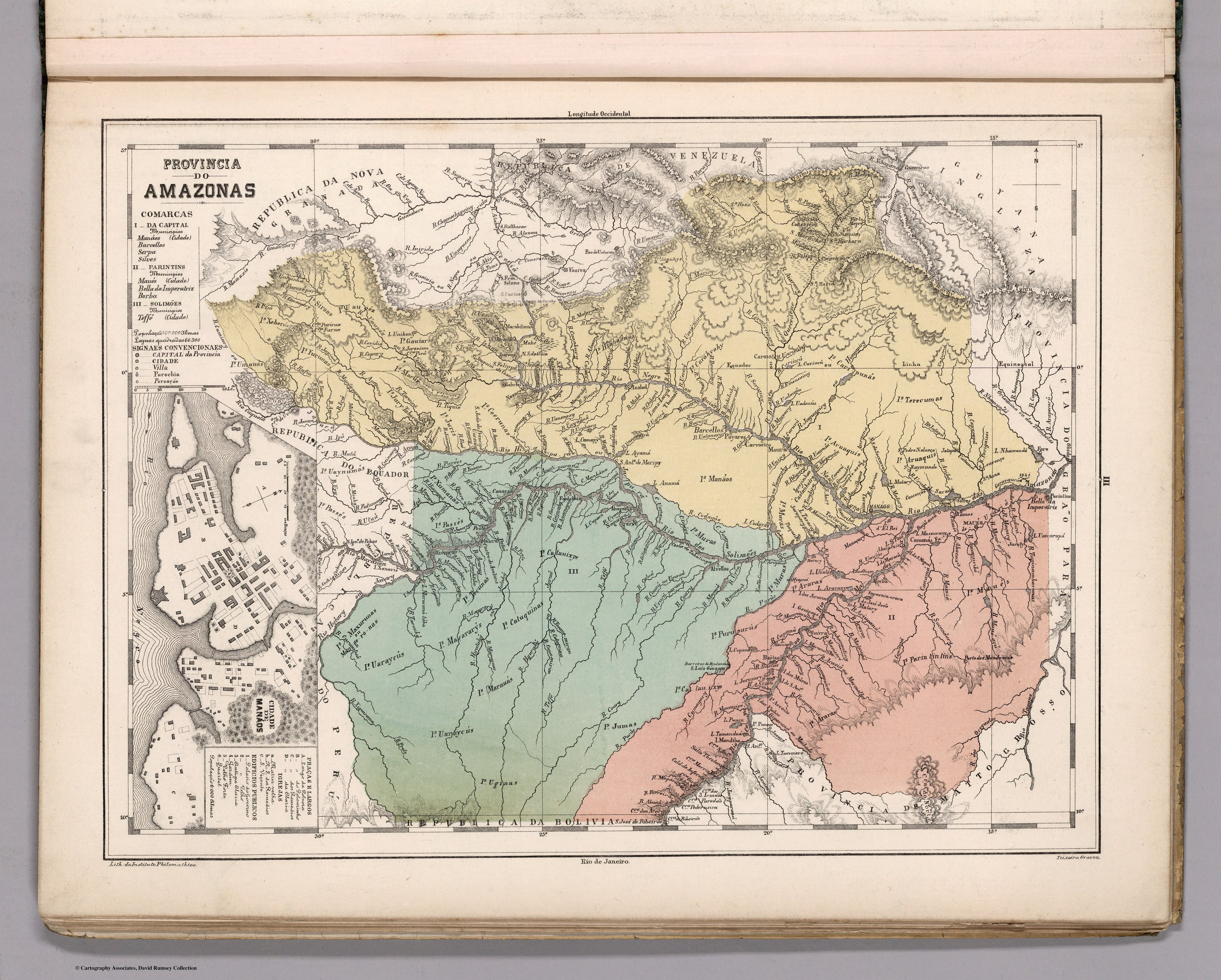
Dispossesions in the Americas

Dispossesions in the Americas

  • Lar
  • Explorar
  • Autores
  • Sobre
  • Arte
  • Corpos
  • Currículos
  • Patrimônio Cultural
  • Mapas
  • Territórios
Voltar à seção Explorar

Lendo em Inglês

Mapa 1800 - 1850

Provincia do AMAZONAS

  • MENDES, CANDIDO

Publicado: 1868

  • Baixar Imagens
  • Baixar Imagens

Lendo em Espanhola

Mapa 1800 - 1850

Provincia do AMAZONAS

  • MENDES, CANDIDO

Publicado: 1868

  • Baixar Imagens
  • Baixar Imagens
Mapa 1800 - 1850

Provincia do AMAZONAS

  • MENDES, CANDIDO

Publicado: 1868

  • Baixar Imagens

Povos

  • CARIPUNAS
  • CARAHYAHY
  • HIABAANAS
  • GAUIARIS
  • MACUS
  • UAUPEZ
  • SIROAS
  • YUCUNAS
  • XEBEROS
  • UMAUAS
  • JURY-TABOCAS
  • JURIS
  • COERUNAS
  • UAYNUMAS
  • PASSES
  • XUMANAS
  • TECUNAS
  • MANAOS
  • MURAS
  • CATAUIXYS
  • TERECUMAS
  • ARUAQUIS
  • ARARAS
  • MAUES
  • PARINTINTINS
  • ARRAIAS
  • PURUPURUS
  • JUMAS
  • CATUQUINAS
  • MACARARYS
  • UARAYCUS
  • MAXURUNAS
  • MARAUAS
  • UGINAS

Citation

Mendes, Candido. Provincia do Amazonas. Map. Rio de Janeiro: Lithographia do Instituto Philomathico, 1868. Accessed August 14, 2023. https://www.davidrumsey.com/ luna/servlet/detail/RUMSEY~8~1~305748~90076439.

  • Baixar Imagens

Itens Relacionados

PARTIE DE LA COLOMBIE

PARTIE DE LA COLOMBIE

Mapa 1825
Plano de la nueba redución de Yndios Tobas
     nombrada San Bernardo de Vertiz

Plano de la nueba redución de Yndios Tobas nombrada San Bernardo de Vertiz

Mapa 1781
RESGUARDO DE TUKUNARE

RESGUARDO DE TUKUNARE

Mapa 2012
Tawahka homeland, 1916: Showing Río Wampú (Wanpo), Río Patuca (Butuk), Cerro Quigungun (Wangkibila Volc [anol]), and the first cartographical rendering of Krautara (Moravian Archives, Bethlehem, Pennsylvania, Heath 1916)

Tawahka homeland, 1916: Showing Río Wampú (Wanpo), Río Patuca (Butuk), Cerro Quigungun (Wangkibila Volc [anol]), and the first cartographical rendering of Krautara (Moravian Archives, Bethlehem, Pennsylvania, Heath 1916)

Mapa 1916
GUIANA AND VENEZUELA

GUIANA AND VENEZUELA

Mapa 1900 - 1999
INTENDENCIA DE DURANGO

INTENDENCIA DE DURANGO

Mapa 1800
THE KARANQAS AYMARA POLITY - Instant shot of trans-border connections around 1900 (Google Earth adaptation)

THE KARANQAS AYMARA POLITY - Instant shot of trans-border connections around 1900 (Google Earth adaptation)

Mapa 1860 - 1930
Crique Sarco

Crique Sarco

Mapa 1997

Desapropriações nas Américas

Um projeto de

University of Pennsylvania

Copyright 2024

Com o apoio de

Mellon Foundation

Projeto e desenvolvimento do site

Element 84

Créditos da arte

Mendes, Candido. Provincia do Amazonas. Map. Rio de Janeiro: Lithographia do Instituto Philomathico, 1868. Accessed August 14, 2023. https://www.davidrumsey.com/ luna/servlet/detail/RUMSEY8130574890076439.

Páginas do site

  • Lar
  • Explorar
  • Autores
  • Sobre
  • Arte
  • Corpos
  • Currículos
  • Patrimônio Cultural
  • Mapas
  • Territórios