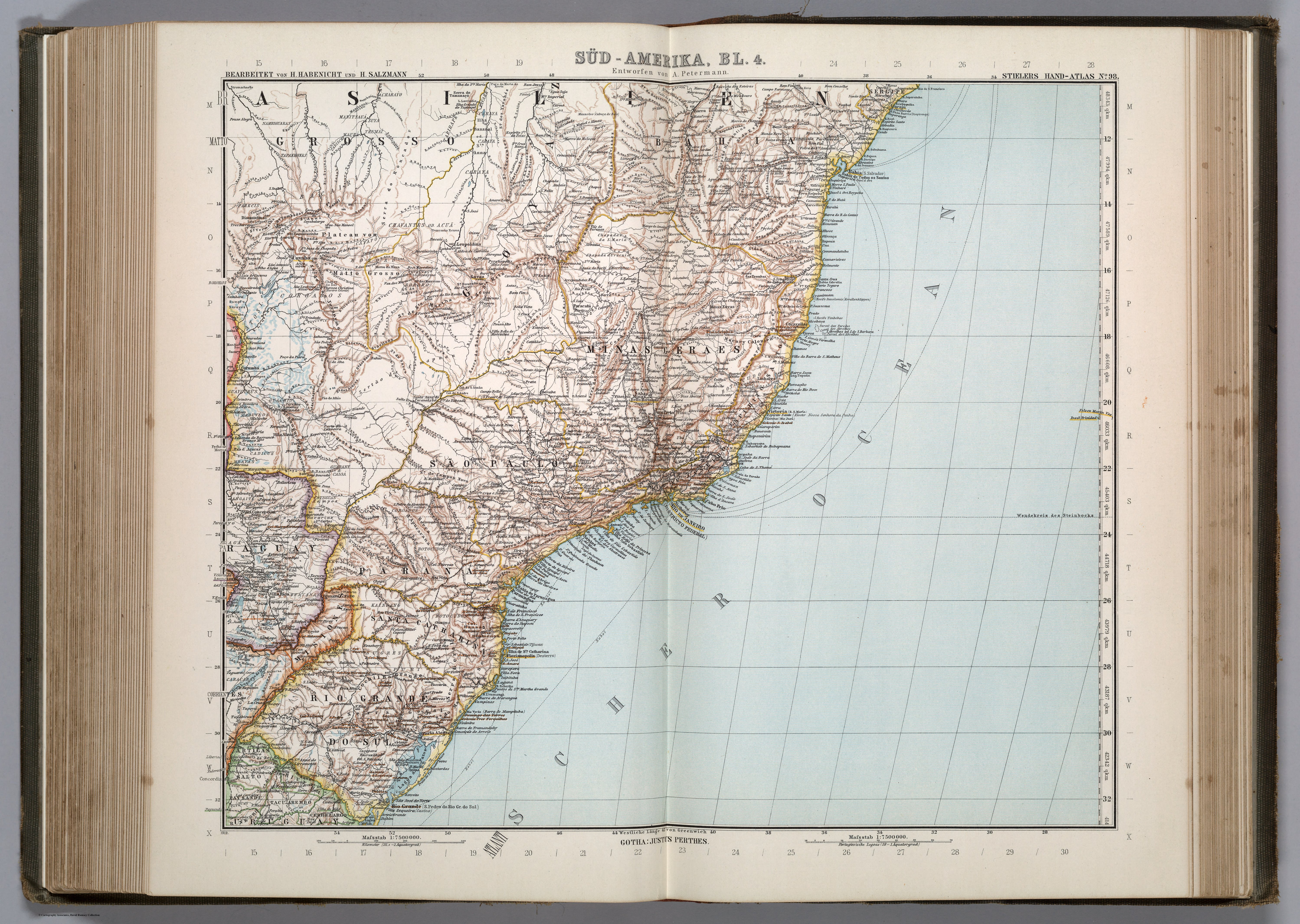
Dispossesions in the Americas

Dispossesions in the Americas

  • Lar
  • Explorar
  • Autores
  • Sobre
  • Arte
  • Corpos
  • Currículos
  • Patrimônio Cultural
  • Mapas
  • Territórios
Voltar à seção Explorar

Lendo em Inglês

Mapa 1911

SÜD-AMERIKA, BL. 4

  • PETERMANN, A.

Publicado: 1911

  • Baixar Imagem
  • Baixar Imagem

Lendo em Espanhol

Mapa 1911

SÜD-AMERIKA, BL. 4

  • PETERMANN, A.

Publicado: 1911

  • Baixar Imagem
  • Baixar Imagem
Mapa 1911

SÜD-AMERIKA, BL. 4

  • PETERMANN, A.

Publicado: 1911

  • Baixar Imagem

Povos

  • CARAYA
  • XAVAHE
  • TAPIRAPE
  • CHARAYO
  • MANITSAUA
  • SUYA
  • TRUMAI
  • WAURA
  • NAMBIGUARAS
  • TAPANHONAS
  • CABISCHI
  • BACAIRI
  • CHAVANTES
  • ACUA
  • CAYAPO
  • BORORO
  • PARECIS
  • GUATOS
  • BOTOCUDOS
  • GUAYCURUS
  • GUACHIS
  • CADUVEOS
  • CADICUS
  • MBAYAS
  • COROADOS
  • CAYUA
  • GUARANY
  • CAIOA
  • CAYNGUAS
  • ANGAITE
  • PILAGA
  • GUAYANAS
  • KAINGANG
  • BUGRES
  • CARACARAS
  • PURI

Citação

Petermann, A., Adolf Stieler, H. Habenicht, and H. Salzmann. Süd-Amerika, Bl. 4. Map. Gotha: Justus Perthes, 1911. Accessed August 4, 2023. https://www.davidrumsey.com/luna/servlet/detail/RUMSEY~8~1~297435~90069027.

  • Baixar Imagem

Itens Relacionados

AL SERMO FERDINANDO II GRANDVCA DI TOSCANA

AL SERMO FERDINANDO II GRANDVCA DI TOSCANA

Mapa 1661
AVA GUARANÍ

AVA GUARANÍ

Mapa 2015
Outlines of the physical and political division of South America: Delineated by A. Arrowsmith partly from scarce and original documents, published before the year 1806 but principally from manuscript maps & surveys made between the years 1771 and 1806, corrected from accurate astronomical observations to 1810.

Outlines of the physical and political division of South America: Delineated by A. Arrowsmith partly from scarce and original documents, published before the year 1806 but principally from manuscript maps & surveys made between the years 1771 and 1806, corrected from accurate astronomical observations to 1810.

Mapa 1800 - 1899
INTENDENCIA DE PUEBLA

INTENDENCIA DE PUEBLA

Mapa 1800
[Embouchures de l'Oyapock et de diverses rivières].

[Embouchures de l'Oyapock et de diverses rivières].

Mapa 1700 - 1799
What did they actually see? [O que é que eles viram realmente?] “Out of control” Pag-127 / “Deviant” Pag-128 / “Possessed” Pag-129 2018

What did they actually see? [O que é que eles viram realmente?] “Out of control” Pag-127 / “Deviant” Pag-128 / “Possessed” Pag-129 2018

Obra de arte
Honduras 1/800.000. Copyright 1909 by E. C. Fiallos

Honduras 1/800.000. Copyright 1909 by E. C. Fiallos

Mapa 1909
PUEBLO KIKAPU

PUEBLO KIKAPU

Mapa 2020

Despossessões nas Américas

Um projeto de

University of Pennsylvania

Copyright 2024

Com o apoio de

Mellon Foundation

Projeto e desenvolvimento do site

Element 84

Créditos da arte

Petermann, A., Adolf Stieler, H. Habenicht, and H. Salzmann. Süd-Amerika, Bl. 4. Map. Gotha: Justus Perthes, 1911. Accessed August 4, 2023. https://www.davidrumsey.com/luna/servlet/detail/RUMSEY~8~1~297435~90069027.

Páginas do site

  • Lar
  • Explorar
  • Autores
  • Sobre
  • Arte
  • Corpos
  • Currículos
  • Patrimônio Cultural
  • Mapas
  • Territórios