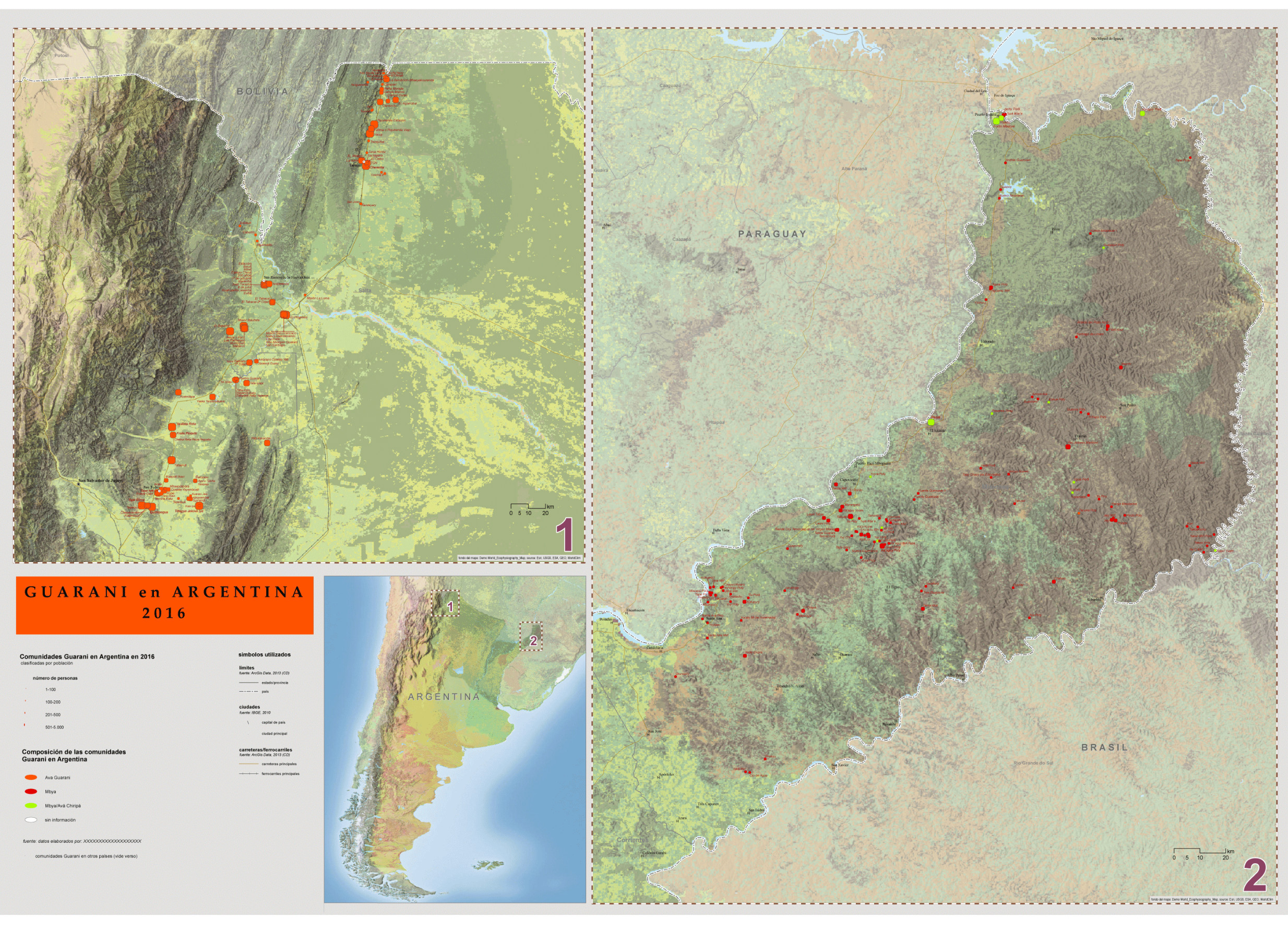
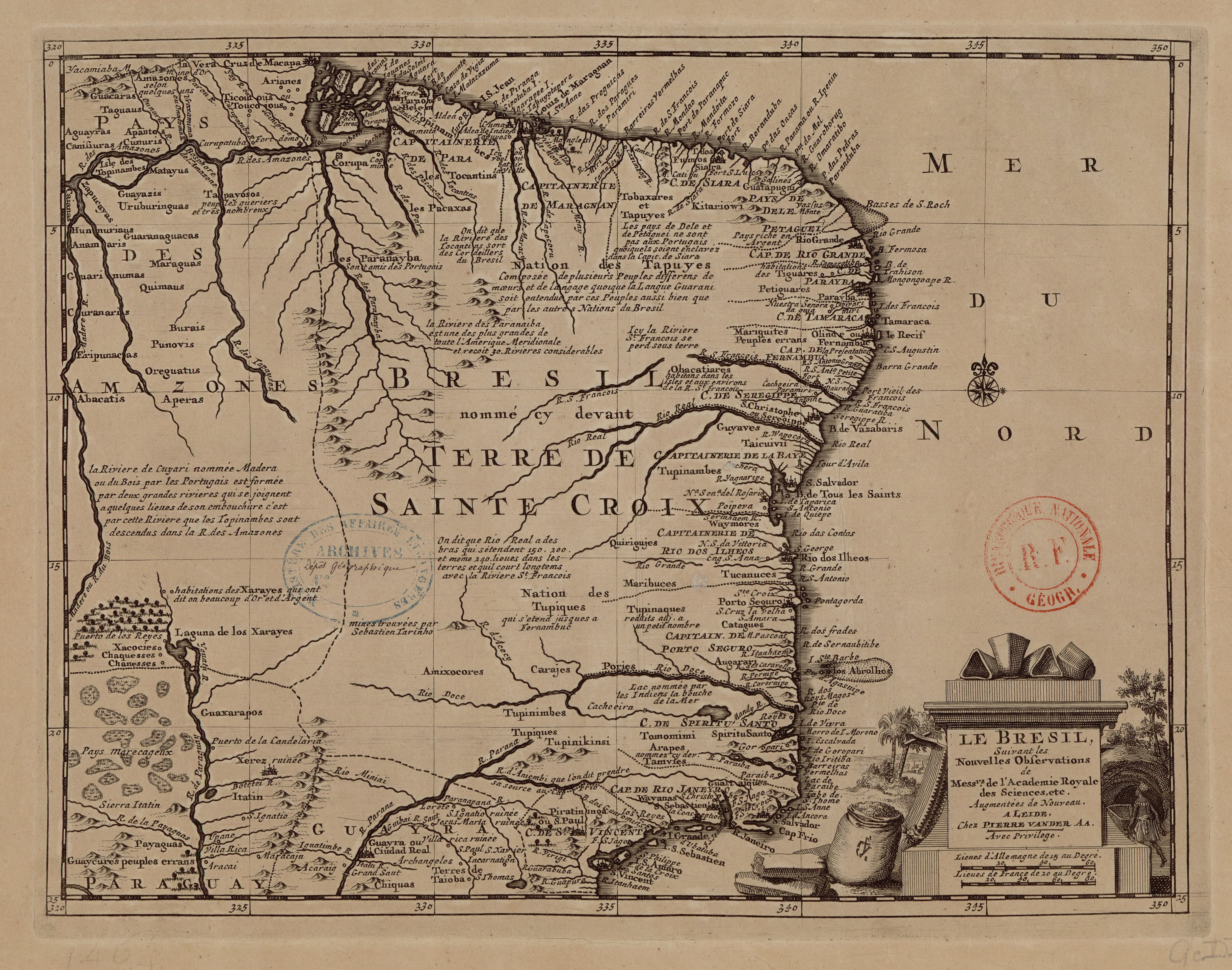
Dispossesions in the Americas

Dispossesions in the Americas

  • Lar
  • Explorar
  • Autores
  • Sobre
  • Arte
  • Corpos
  • Currículos
  • Patrimônio Cultural
  • Mapas
  • Territórios
Voltar à seção Explorar

Lendo em Inglês

Mapa 1714

LE BRESIL

  • L'ACADEMIE ROYALE DES SCIENCES, ET AL.

Publicado: 1714

  • Baixar Imagem
  • Baixar Imagem

Lendo em Espanhol

Mapa 1714

LE BRESIL

  • L'ACADEMIE ROYALE DES SCIENCES, ET AL.

Publicado: 1714

  • Baixar Imagem
  • Baixar Imagem
Mapa 1714

LE BRESIL

  • L'ACADEMIE ROYALE DES SCIENCES, ET AL.

Publicado: 1714

  • Baixar Imagem

Povos

  • KITARIOWI
  • SIARA
  • FUMOS
  • GUATAPUGUI
  • TOBAXARES
  • TAPUYES
  • TOPINAMBES
  • TOCANTINS
  • PACAXAS
  • ARIANES
  • TICOUTOUS
  • TOUCOJOUS
  • AMAZONES
  • GUACARAS
  • TAGUAUS
  • APANTOS
  • CUNURIS
  • AGUAYRAS
  • CANISIURAS
  • MATAYUS
  • GUAYAZIS
  • URUBURINGUAS
  • ZAPUCAYAS
  • CAIANAS
  • TAPAYOSOS
  • HUNNURIAUS
  • ANAMARIS
  • GUARANAGUACAS
  • MARAGUAS
  • QUIMAUS
  • CURANARIS
  • BURAIS
  • PUNOVIS
  • ERIPUNACAS
  • OREGUATUS
  • PARANAYBA
  • OBACATIARES
  • MARIQUITES
  • PETIGUARES
  • TIGUARES
  • GUYAVES
  • TAICUIVII
  • TUPINAMBES
  • WAYMORES
  • QUIRIGUJES
  • XARAYES
  • XACOCIES
  • CHAQUESSES
  • CHANESSES
  • GUAXARAPOS
  • AMIXOCORES
  • TUPINIMBES
  • CARAJES
  • TUCANUCES
  • MARIBUCES
  • TUPINAQUES
  • CATAGUES
  • AUGARARI
  • TOMOMIMI
  • ARAPES
  • TAMVIES
  • GUAITAIQUES
  • WAYANAS
  • TUPIQUES
  • TUPINIKINSI
  • PIRATININGA
  • CHIQUAS
  • ITATIN
  • PAYAGUAS
  • GUAYCURES

Citação

L'Academie Royale des Sciences, and Pierre Van der Aa. Le Brésil. Map. Leiden: Pierre Van der Aa, 1714. Accessed July 24, 2023. https://gallica.bnf.fr/ark:/12148/btv1b8596678p/f1.item.

  • Baixar Imagem

Itens Relacionados

Guaraní en Argentina 2016, Pueblos Guaraníes en América del Sur 2016

Guaraní en Argentina 2016, Pueblos Guaraníes en América del Sur 2016

Mapa 2016
Distribución estatal de Tseltal

Distribución estatal de Tseltal

Mapa 2005
Map of Mapuche Land Dispossession for Chilean and German Settlers

Map of Mapuche Land Dispossession for Chilean and German Settlers

Mapa 1911 - 1952
Terra Indígena Tenondé Porã

Terra Indígena Tenondé Porã

Mapa 2011
Carte de l'embouchure d'Ouyapoc

Carte de l'embouchure d'Ouyapoc

Mapa 1700 - 1799
The modern departments of Ahuachapán, La Libertad, Santa Ana, and Sonsonate (highlighted in red) now contain the highest concentration of Indigenous communities in El Salvador.

The modern departments of Ahuachapán, La Libertad, Santa Ana, and Sonsonate (highlighted in red) now contain the highest concentration of Indigenous communities in El Salvador.

Mapa 2010
Mano and Sutna territory compared with Lehtner's Jornada Mogotton territory

Mano and Sutna territory compared with Lehtner's Jornada Mogotton territory

Mapa 1997
Zoque Towns

Zoque Towns

Mapa 1969

Despossessões nas Américas

Um projeto de

University of Pennsylvania

Copyright 2024

Com o apoio de

Mellon Foundation

Projeto e desenvolvimento do site

Element 84

Créditos da arte

L’Academie Royale des Sciences, and Pierre Van der Aa. Le Brésil. Map. Leiden: Pierre Van der Aa, 1714. Accessed July 24, 2023. https://gallica.bnf.fr/ark:/12148/btv1b8596678p/f1.item.

Páginas do site

  • Lar
  • Explorar
  • Autores
  • Sobre
  • Arte
  • Corpos
  • Currículos
  • Patrimônio Cultural
  • Mapas
  • Territórios