Dispossesions in the Americas

Dispossesions in the Americas

  • Lar
  • Explorar
  • Autores
  • Sobre
  • Arte
  • Corpos
  • Currículos
  • Patrimônio Cultural
  • Mapas
  • Territórios
Voltar à seção Explorar

Lendo em Inglês

Mapa 1717

The Great River Marañon or of the Amazons

  • FRITZ, SAMUEL

Publicado: 1717

  • Baixar Imagem
  • Baixar Imagem

Lendo em Espanhol

Mapa 1717

The Great River Marañon or of the Amazons

  • FRITZ, SAMUEL

Publicado: 1717

  • Baixar Imagem
  • Baixar Imagem
Mapa 1717

The Great River Marañon or of the Amazons

  • FRITZ, SAMUEL

Publicado: 1717

  • Baixar Imagem

Povos

  • GUARANACUAS
  • TUMAUARI
  • MAASES
  • CAUAURBAN
  • AUATAYARI
  • CARIMUNAS
  • TUCUYUS
  • COMAU
  • GUAYARUS
  • COMURA
  • PACAYAS
  • CURIVARES
  • YURUNAS
  • BOCAS
  • XINGU
  • TACUANAPOS
  • CUSARI
  • TOPAYOS
  • GAIAYAPIS
  • ARITU
  • ARAPIYU
  • MARAGUALES
  • MABUES
  • SAPUPES
  • YGAPUTARIYARA
  • PATENIANAS
  • AUACADUS
  • ANDIRASES
  • ARARAS
  • ARIPUANA
  • IRURISES
  • YAVEIS
  • CUCHIUARAS
  • YEOMAMAIS
  • PAUANAS
  • YBANOMAS
  • YOEMAMAIS
  • HUAIRUAS
  • IUANURUS
  • YEMAMAIS
  • HUAHUATATES
  • AUANATEOS
  • CAAPINAS
  • APAMAS
  • COPARIPUCU
  • CUNDURISES
  • SAMUNDASES
  • ARUBAQUIS
  • CUAPOANAS
  • MAYEPIEN
  • GUAYOANAS
  • CURANATIES
  • BAHOANA
  • CARARUENI
  • CAUAURI
  • MANAUES
  • CARIEY
  • CAUACAVAS
  • AICUARES
  • MORUAS
  • CASUANAS
  • PARIANAS
  • ICATES
  • GUAREICUS
  • NAUNUS
  • CURINAS
  • YACARIUARIAS
  • CHIUS
  • HUAYAS
  • SUCBIOS
  • ENCABELLDOS
  • PAYAUAS
  • SEMIGAVES
  • ABIJIRAS
  • ANDEAS
  • AUNALAS
  • YAMEOS
  • MAYNAS
  • CAPANATUAS
  • CAMBRAS
  • PIROS
  • CHITINOS

Citação

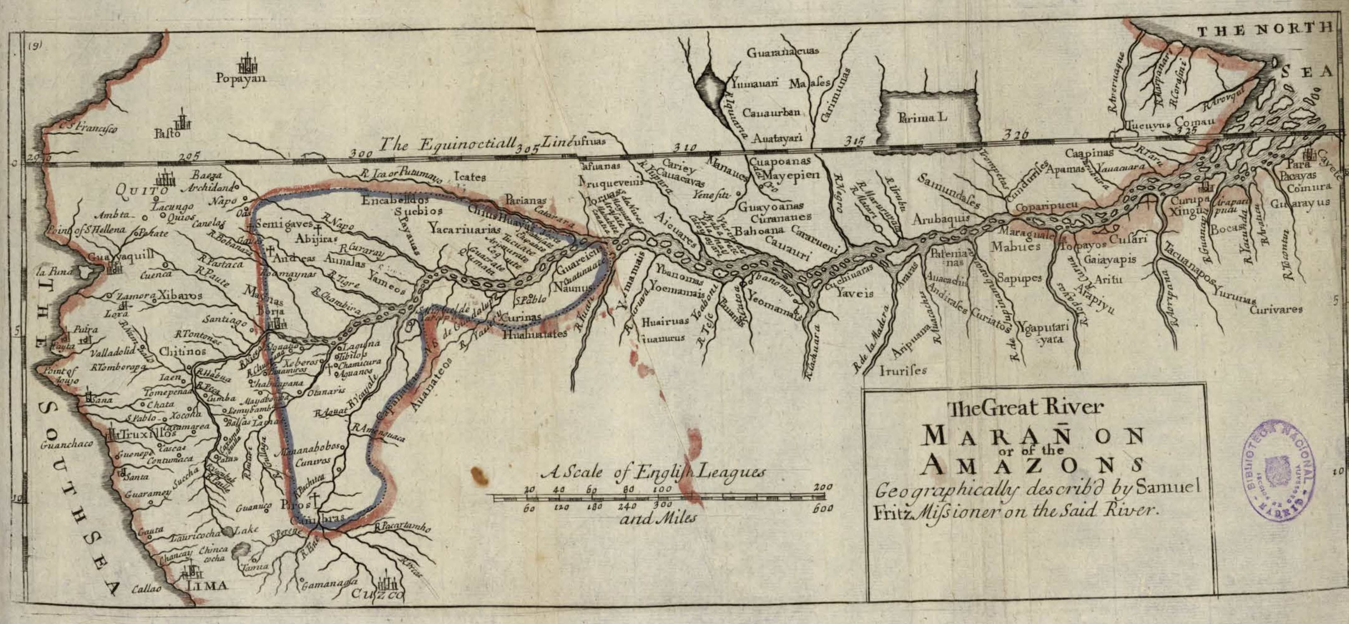
Fritz, Samuel. "The Great River Marañon or of the Amazons." Map. In America, by Herman Moll, 389. Vol. 5 of Atlas Geographus or, a compleat System of Geography, ancient and modern. London: John Nutt, 1717. Accessed July 14, 2023. http://bdh.bne.es/bnesearch/detalle/bdh0000163462.

  • Baixar Imagem

Itens Relacionados

Carte de la Moskitie oú se fonde la Neustrie

Carte de la Moskitie oú se fonde la Neustrie

Mapa 1830
BRASIL

BRASIL

Mapa 1822
N. 100. Carte de la Guyane Française

N. 100. Carte de la Guyane Française

Mapa 1878
GEOGRAPHISCH-STATISTISCHE UND HISTORISCHE CHARTE VON COLUMBIA

GEOGRAPHISCH-STATISTISCHE UND HISTORISCHE CHARTE VON COLUMBIA

Mapa 1824
Mazatec Area

Mazatec Area

Mapa 1969
Plan topográfico de las Provincias de Chocó, Antioquia y Popayán

Plan topográfico de las Provincias de Chocó, Antioquia y Popayán

Mapa 1700
Carte du Paraguay;du Chili;du Detroit de Magellan &c. Dressée sur les descriptions des PP. Alfonse d'Ovalle;et Nicolas Techo;et sur les relations et memoires de Brouwer;Narbouroug;Mr. de Beauchesne &c.

Carte du Paraguay;du Chili;du Detroit de Magellan &c. Dressée sur les descriptions des PP. Alfonse d'Ovalle;et Nicolas Techo;et sur les relations et memoires de Brouwer;Narbouroug;Mr. de Beauchesne &c.

Mapa 1703
El Territorio de los Chibchas

El Territorio de los Chibchas

Mapa 1500 - 1599

Despossessões nas Américas

Um projeto de

University of Pennsylvania

Copyright 2024

Com o apoio de

Mellon Foundation

Projeto e desenvolvimento do site

Element 84

Créditos da arte

Fritz, Samuel. “The Great River Marañon or of the Amazons.” Map. In America, by Herman Moll, 389. Vol. 5 of Atlas Geographus or, a compleat System of Geography, ancient and modern. London: John Nutt, 1717. Accessed July 14, 2023. http://bdh.bne.es/bnesearch/detalle/bdh0000163462.

Páginas do site

  • Lar
  • Explorar
  • Autores
  • Sobre
  • Arte
  • Corpos
  • Currículos
  • Patrimônio Cultural
  • Mapas
  • Territórios