Povos
- MOSQUITO
Citação
Pieter van Ley. n.d. "Map showing Caribbean coast of Central America from Belize to Nicaragua." Library of Congress Geography and Map Division, G4802.C6 17-- .M31. http://hdl.loc.gov/loc.gmd/g4802c.lh000067
CARTE DE LA COSTE DEPUIS LA RIVIERE DES AMAZONES JUSQUES A L'ISLE DE CAYENNE
Mapa 1701
Pueblos indígenas Brasil no amazónico
Mapa 2009
Mapa de la América Central comprendida entre el Golfo Dulce y Cartagena de Indias;por el Norte y entre la Bahía de Fonseca de Panamá por el Sur.
Mapa 1777
Pueblos y territorios indígenas de Honduras (2000)
Mapa 2000
Plano de La Habana, en perspectiva.
Mapa 1500 - 1599
Location of the main settlements on the Lenca-Chortí-Nahua-Pipil frontier, 1530-1539. (Taken from Lara-Pinto 2009 with modifications.)
Mapa 1530 - 1539
Nieuwe Caerte van het wonderbaer ende goudrijcke landt Guiana, gelegen onder de Linie Aequinoctiael tusschen Brasilien ende Péru.
Mapa 1500 - 1599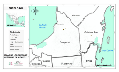
PUEBLO IXIL
Mapa 2020