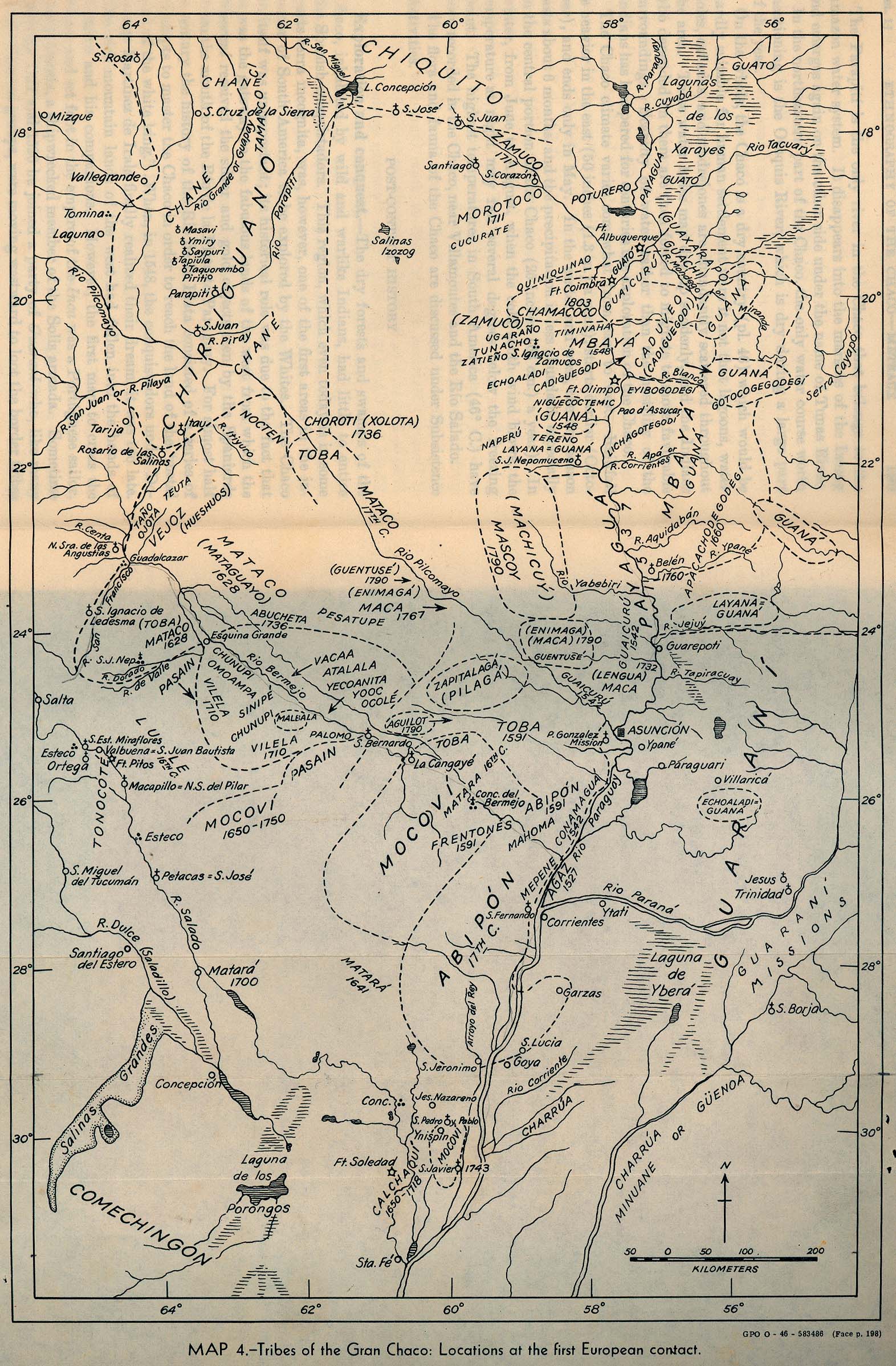
Dispossesions in the Americas

Dispossesions in the Americas

  • Lar
  • Explorar
  • Autores
  • Sobre
  • Arte
  • Corpos
  • Currículos
  • Patrimônio Cultural
  • Mapas
  • Territórios
Voltar à seção Explorar

Lendo em Inglês

Mapa 2009

Pueblos indígenas en Argentina chaqueña

  • Valdivia, Fredy

Publicado: 2009

  • Baixar Imagens
  • Baixar Imagens

Lendo em Espanhola

Mapa 2009

Pueblos indígenas en Argentina chaqueña

  • Valdivia, Fredy

Publicado: 2009

  • Baixar Imagens
  • Baixar Imagens
Mapa 2009

Pueblos indígenas en Argentina chaqueña

  • Valdivia, Fredy

Publicado: 2009

  • Baixar Imagens

Povos

  • AVA-GUARANI
  • CHANE
  • CHARRUA
  • CHOROTE
  • LULE
  • MBYA
  • MOCOVI
  • NIVACLE
  • PILAGA
  • TAPIETE
  • TOBA
  • TONOCOTE
  • WICHI

Citation

Unicef. "Atlas sociolingüístico de pueblos indígenas en América Latina." Pg. 168. 2009. Accessed September 2021. https://www.unicef.org/lac/media/9791/file/PDF%20Atlas%20sociolinguistico%20de%20pueblos%20ind%C3%ADgenas%20en%20ALC-Tomo%201.pdf

  • Baixar Imagens

Itens Relacionados

PUEBLO MARINAHUA

PUEBLO MARINAHUA

Mapa 2021
Theories of Migration (Minuanes).

Theories of Migration (Minuanes).

Mapa 1680 - 1805
Plano del río de San Juan (Nicaragua)

Plano del río de San Juan (Nicaragua)

Mapa 1673
A Map of the Provinces Paraguay and Tucuman with the
     River Plate

A Map of the Provinces Paraguay and Tucuman with the River Plate

Mapa 1698
SÜD-AMERIKA, BL. 4

SÜD-AMERIKA, BL. 4

Mapa 1911
CARTA GEOGRÁFICA DEL ECUADOR POR DR. TEODORO WOLF;PUBLICADA POR ORDEN DEL SUPREMO GOBIERNO DE LA REPÚBLICA Y TRABAJADA BAJO LAS PRESIDENCIAS DE LOS EE. SEÑORES DR. D.J.M. PLÁCIDO CAAMAÑO Y DR. D. ANTONIO FLORES. 1892 ... INSTITUTO GEOGRAFICO DE H. WAGNER & E. DEBES EN LEIPZIG. (WITH) LA REGION ORIENTAL DEL ECUADOR. (WITH) ARCHIPIÉLAGO DE GALÁPAGOS.

CARTA GEOGRÁFICA DEL ECUADOR POR DR. TEODORO WOLF;PUBLICADA POR ORDEN DEL SUPREMO GOBIERNO DE LA REPÚBLICA Y TRABAJADA BAJO LAS PRESIDENCIAS DE LOS EE. SEÑORES DR. D.J.M. PLÁCIDO CAAMAÑO Y DR. D. ANTONIO FLORES. 1892 ... INSTITUTO GEOGRAFICO DE H. WAGNER & E. DEBES EN LEIPZIG. (WITH) LA REGION ORIENTAL DEL ECUADOR. (WITH) ARCHIPIÉLAGO DE GALÁPAGOS.

Mapa 1892
Tribes of the Gran Chaco: Locations at the first European contact

Tribes of the Gran Chaco: Locations at the first European contact

Mapa 1524
REGIÓN CHIMALAPAS

REGIÓN CHIMALAPAS

Mapa 2000

Desapropriações nas Américas

Um projeto de

University of Pennsylvania

Copyright 2024

Com o apoio de

Mellon Foundation

Projeto e desenvolvimento do site

Element 84

Créditos da arte

Unicef. “Atlas sociolingüístico de pueblos indígenas en América Latina.” Pg. 168. 2009. Accessed September 2021. https://www.unicef.org/lac/media/9791/file/PDF%20Atlas%20sociolinguistico%20de%20pueblos%20ind%C3%ADgenas%20en%20ALC-Tomo%201.pdf

Páginas do site

  • Lar
  • Explorar
  • Autores
  • Sobre
  • Arte
  • Corpos
  • Currículos
  • Patrimônio Cultural
  • Mapas
  • Territórios