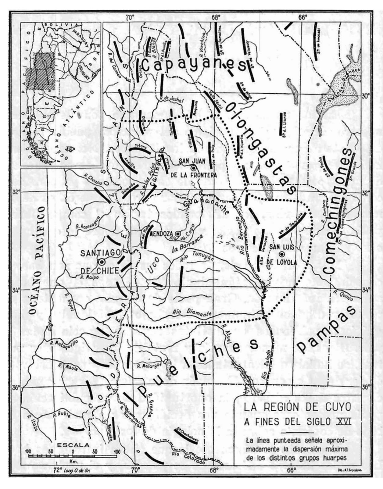
Dispossesions in the Americas

Dispossesions in the Americas

  • Lar
  • Explorar
  • Autores
  • Sobre
  • Arte
  • Corpos
  • Currículos
  • Patrimônio Cultural
  • Mapas
  • Territórios
Voltar à seção Explorar

Lendo em Inglês

Mapa 1590

La región de Cuyo a fines del siglo XVI

  • CANALS FRAU, SALVADOR

Publicado: 1946

  • Baixar Imagens
  • Baixar Imagens

Lendo em Espanhola

Mapa 1590

La región de Cuyo a fines del siglo XVI

  • CANALS FRAU, SALVADOR

Publicado: 1946

  • Baixar Imagens
  • Baixar Imagens
Mapa 1590

La región de Cuyo a fines del siglo XVI

  • CANALS FRAU, SALVADOR

Publicado: 1946

  • Baixar Imagens

Povos

  • PAMPAS
  • PUELCHE
  • COMECHINGON
  • OLONGASTA
  • CAPAYAN

Citation

"La región de cuyo a fines del siglo XVI." Map. In Anales del Instituto de Etnología Americana, by Salvador Canals Frau, 10. Vol. 7 of Etnologia de los Huarpes: una sintesis. 1946. Accessed June 5, 2021. https://bdigital.uncu.edu.ar/objetos_digitales/13712/rev-anales-1946-vol7-parte2.pdf

  • Baixar Imagens

Itens Relacionados

Población o'ob (pima) en 2010

Población o'ob (pima) en 2010

Mapa 2010
Railroad Map of British Honduras Transportation Department of the United States Department of Commerce. Library of Congress Geography and Map Division. https://hdl.loc.gov/loc.wdl/wdl.11329

Railroad Map of British Honduras Transportation Department of the United States Department of Commerce. Library of Congress Geography and Map Division. https://hdl.loc.gov/loc.wdl/wdl.11329

Mapa 1900
Descripción de las Indias Occidentales: Audiencia de Guatemala-Madrid

Descripción de las Indias Occidentales: Audiencia de Guatemala-Madrid

Mapa 1600 - 1699
A Sequel of the Seat of War in the West Indies containing… Sub-map title: A large & accurate MAP of part of the Isthmus of Panama, taken from a Spanish drought exhibiting the Country adjacent to that City and Puerto Bello, with the Roads and Course of the River CHAGRE, by which the Treasure of the South Sea is conveyed a cross the Isthmus

A Sequel of the Seat of War in the West Indies containing… Sub-map title: A large & accurate MAP of part of the Isthmus of Panama, taken from a Spanish drought exhibiting the Country adjacent to that City and Puerto Bello, with the Roads and Course of the River CHAGRE, by which the Treasure of the South Sea is conveyed a cross the Isthmus

Mapa 1740
Carte réduite des Côtes de la Guyane comprenant les Bouches de la Rivière des Amazones jusqu'à l'Ile de la Trinité

Carte réduite des Côtes de la Guyane comprenant les Bouches de la Rivière des Amazones jusqu'à l'Ile de la Trinité

Mapa 1817
Placa

Placa

Obra de arte
Veta Negra [Veia Negra]

Veta Negra [Veia Negra]

Obra de arte
Lenguas indígenas según departamentos

Lenguas indígenas según departamentos

Mapa 2004

Desapropriações nas Américas

Um projeto de

University of Pennsylvania

Copyright 2024

Com o apoio de

Mellon Foundation

Projeto e desenvolvimento do site

Element 84

Créditos da arte

“La región de cuyo a fines del siglo XVI.” Map. In Anales del Instituto de Etnología Americana, by Salvador Canals Frau, 10. Vol. 7 of Etnologia de los Huarpes: una sintesis. 1946. Accessed June 5, 2021. https://bdigital.uncu.edu.ar/objetos_digitales/13712/rev-anales-1946-vol7-parte2.pdf

Páginas do site

  • Lar
  • Explorar
  • Autores
  • Sobre
  • Arte
  • Corpos
  • Currículos
  • Patrimônio Cultural
  • Mapas
  • Territórios