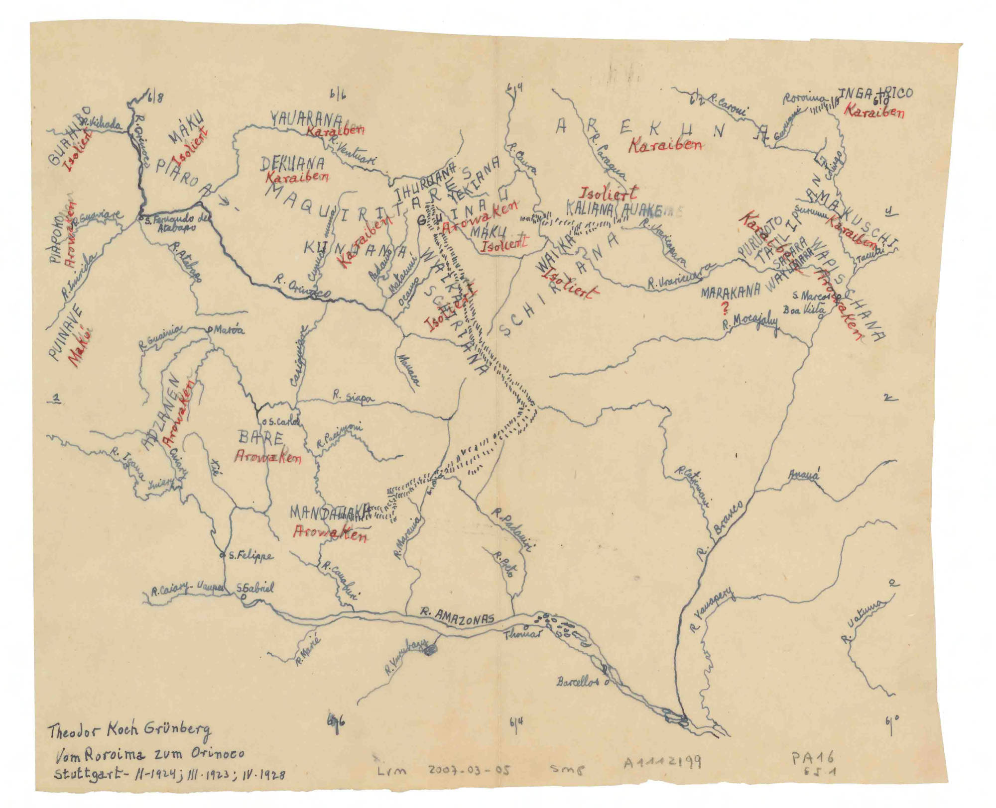
Dispossesions in the Americas

Dispossesions in the Americas

  • Inicio
  • Explorar
  • Autores
  • Sobre
  • Arte
  • Cuerpos
  • Planes de Estudio
  • Herencia Cultural
  • Mapas
  • Territorios
Volver a Explorar

Leyendo en Inglés

Mapa 1923 - 1928

Vom Roroima zum Orinoco

  • KOCH-GRUNBERG, THEODOR

Publicado: 1928

  • Descargar Imágen
  • Descargar Imágen
Mapa 1923 - 1928

Vom Roroima zum Orinoco

  • KOCH-GRUNBERG, THEODOR

Publicado: 1928

  • Descargar Imágen

Pueblos

  • KARAIBEN
  • AROWAKEN
  • ISOLIERT
  • MAKU
  • MAKUSCHI
  • WAPISCHANA
  • PURUGOTO
  • SAPARA
  • WAYUMARA
  • TATILIPAN
  • AREKUNA
  • INGARICO
  • MARAKANA
  • KALIANA
  • AUAKE
  • WAIKA
  • SCHIRIANA
  • GUINAU
  • YEKIANA
  • IHURUANA
  • MAQUIRITARES
  • DEKUANA
  • YAUARANA
  • KUNUANA
  • PIAROA
  • GUAHIBO
  • PIAPOKO
  • PUINAVE
  • ADZANEN
  • BARE
  • MANDAWAKA

Cita

Koch-Grunberg, Theodor. Vom Roroima zum Orinoco. Map. Stuttgart, 1923;1924;1928. Accessed July 6, 2023. https://babel.banrepcultural.org/digital/collection/p17054coll13/id/679/rec/3.

  • Descargar Imágen

Leyendo en Portugués

Mapa 1923 - 1928

Vom Roroima zum Orinoco

  • KOCH-GRUNBERG, THEODOR

Publicado: 1928

  • Descargar Imágen

Pueblos

  • KARAIBEN
  • AROWAKEN
  • ISOLIERT
  • MAKU
  • MAKUSCHI
  • WAPISCHANA
  • PURUGOTO
  • SAPARA
  • WAYUMARA
  • TATILIPAN
  • AREKUNA
  • INGARICO
  • MARAKANA
  • KALIANA
  • AUAKE
  • WAIKA
  • SCHIRIANA
  • GUINAU
  • YEKIANA
  • IHURUANA
  • MAQUIRITARES
  • DEKUANA
  • YAUARANA
  • KUNUANA
  • PIAROA
  • GUAHIBO
  • PIAPOKO
  • PUINAVE
  • ADZANEN
  • BARE
  • MANDAWAKA

Cita

Koch-Grunberg, Theodor. Vom Roroima zum Orinoco. Map. Stuttgart, 1923;1924;1928. Accessed July 6, 2023. https://babel.banrepcultural.org/digital/collection/p17054coll13/id/679/rec/3.

  • Descargar Imágen

Artículos Relacionados

Angaité

Angaité

Mapa 2001
AFBEELDING DER STADT EN FORTRESSEN VAN PARAYBA

AFBEELDING DER STADT EN FORTRESSEN VAN PARAYBA

Mapa 1600 - 1650
Cartografía hispano colonial de Chile

Cartografía hispano colonial de Chile

Mapa 1500 - 1800
Mixe Towns

Mixe Towns

Mapa 1969
Mapa de localización del Territorio de la Nación Pueblo Ocloya-Provincia de Jujuy-Argentina

Mapa de localización del Territorio de la Nación Pueblo Ocloya-Provincia de Jujuy-Argentina

Mapa 2016
PUEBLO CHINANTECO

PUEBLO CHINANTECO

Mapa 2020
Indigenous provinces in El Salvador around 1500. (Adapted from Fowler 1989140-141, figure 5, with additional information from Lehman 1920:719, with modifications by the author.)

Indigenous provinces in El Salvador around 1500. (Adapted from Fowler 1989140-141, figure 5, with additional information from Lehman 1920:719, with modifications by the author.)

Mapa 1500
AMERIQUE MERIDIONALE

AMERIQUE MERIDIONALE

Mapa 1750

Despojos en las Américas

Un Proyecto de

University of Pennsylvania

Copyright 2024

Con el apoyo de

Mellon Foundation

Diseño y Desarrollo del Sitio

Element 84

Créditos Artísticos

Koch-Grunberg, Theodor. Vom Roroima zum Orinoco. Map. Stuttgart, 1923;1924;1928. Accessed July 6, 2023. https://babel.banrepcultural.org/digital/collection/p17054coll13/id/679/rec/3.

Páginas del Sitio

  • Inicio
  • Explorar
  • Autores
  • Sobre
  • Arte
  • Cuerpos
  • Planes de Estudio
  • Herencia Cultural
  • Mapas
  • Territorios