Dispossesions in the Americas

Dispossesions in the Americas

  • Inicio
  • Explorar
  • Autores
  • Sobre
  • Arte
  • Cuerpos
  • Planes de Estudio
  • Herencia Cultural
  • Mapas
  • Territorios
Volver a Explorar

Leyendo en Inglés

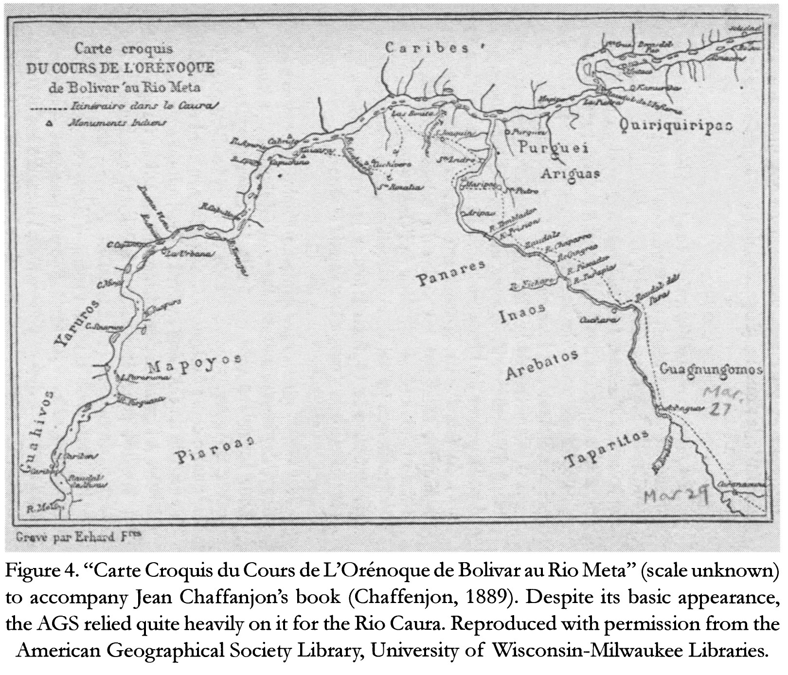
Mapa 1884

Carte Croquis DU COURS DE L'ORÉNOQUE de Bolivar àu Rio Meta

  • CHAFFANJON;JEAN

Publicado: 2015

  • Descargar Imágen
  • Descargar Imágen
Mapa 1884

Carte Croquis DU COURS DE L'ORÉNOQUE de Bolivar àu Rio Meta

  • CHAFFANJON;JEAN

Publicado: 2015

  • Descargar Imágen

Pueblos

  • CARIBE
  • QUIRIQUIRIPAS
  • PURGUEI
  • ARIGUAS
  • ENEPA
  • INAOS
  • AREBATOS
  • TAPARITAS
  • GUAGNUNGOMOS
  • YARURO
  • MAPOYO
  • PIAROA
  • JIVI

Citas

Chaffanjon;Jean. "Carte Croquis du Cours de L'Orénoque de Bolivar au Rio Meta." Map. In Revealing the 'Lost World': The American Geographical Society and the Mapping of Roraima during the 1930s;by Alastair Pearson and Michael Heffernan;188. Vol. 14. Journal of Latin American Geography;2015. Accessed March 4;2023. https://www.jstor.org/stable/43964634?seq=19.
  • Descargar Imágen

Artículos Relacionados

A draught of the country near Blewfields Bluff on the Mosquito Shore

A draught of the country near Blewfields Bluff on the Mosquito Shore

Mapa 1757
Major Places of Mayo Settlement

Major Places of Mayo Settlement

Mapa 1969
PINTURA DE IZTAPALAPA

PINTURA DE IZTAPALAPA

Mapa 1500 - 1599
Indígenas Gamela no Cerrado Piauiense

Indígenas Gamela no Cerrado Piauiense

Mapa 2000 - 2099
THE EASTERN BORDERS OF THE QULLASUYU - SOUTHERN DISTRICT OF THE INCA STATE - 16th CENTURY

THE EASTERN BORDERS OF THE QULLASUYU - SOUTHERN DISTRICT OF THE INCA STATE - 16th CENTURY

Mapa 1400 - 1499
Plan de l'Isle de Cayenne et des rivières voisines, sur lesquelles sont situées les habit.ons, depuis la rivière d'Oyac, jusqu'à la Rivière de Kourou, près de laquelle les PP Jésuites ont établi leur mission des Indiens Galibis.

Plan de l'Isle de Cayenne et des rivières voisines, sur lesquelles sont situées les habit.ons, depuis la rivière d'Oyac, jusqu'à la Rivière de Kourou, près de laquelle les PP Jésuites ont établi leur mission des Indiens Galibis.

Mapa 1721
Territorio Rama y Kriol: Mapa de Zonas Territoriales. Three Zones proposed by the PADA to ensure a sustainable future for the communities of Rama and Kriol

Territorio Rama y Kriol: Mapa de Zonas Territoriales. Three Zones proposed by the PADA to ensure a sustainable future for the communities of Rama and Kriol

Mapa 2000
COLOMBIA AND GUIANA

COLOMBIA AND GUIANA

Mapa 1830

Despojos en las Américas

Un Proyecto de

University of Pennsylvania

Copyright 2024

Con el apoyo de

Mellon Foundation

Diseño y Desarrollo del Sitio

Element 84

Créditos Artísticos

Chaffanjon;Jean. “Carte Croquis du Cours de L’Orénoque de Bolivar au Rio Meta.” Map. In Revealing the ‘Lost World’: The American Geographical Society and the Mapping of Roraima during the 1930s;by Alastair Pearson and Michael Heffernan;188. Vol. 14. Journal of Latin American Geography;2015. Accessed March 4;2023. https://www.jstor.org/stable/43964634?seq=19.
Páginas del Sitio

  • Inicio
  • Explorar
  • Autores
  • Sobre
  • Arte
  • Cuerpos
  • Planes de Estudio
  • Herencia Cultural
  • Mapas
  • Territorios