Dispossesions in the Americas

Dispossesions in the Americas

  • Inicio
  • Explorar
  • Autores
  • Sobre
  • Arte
  • Cuerpos
  • Planes de Estudio
  • Herencia Cultural
  • Mapas
  • Territorios
Volver a Explorar

Leyendo en Inglés

Mapa 1835 - 1844

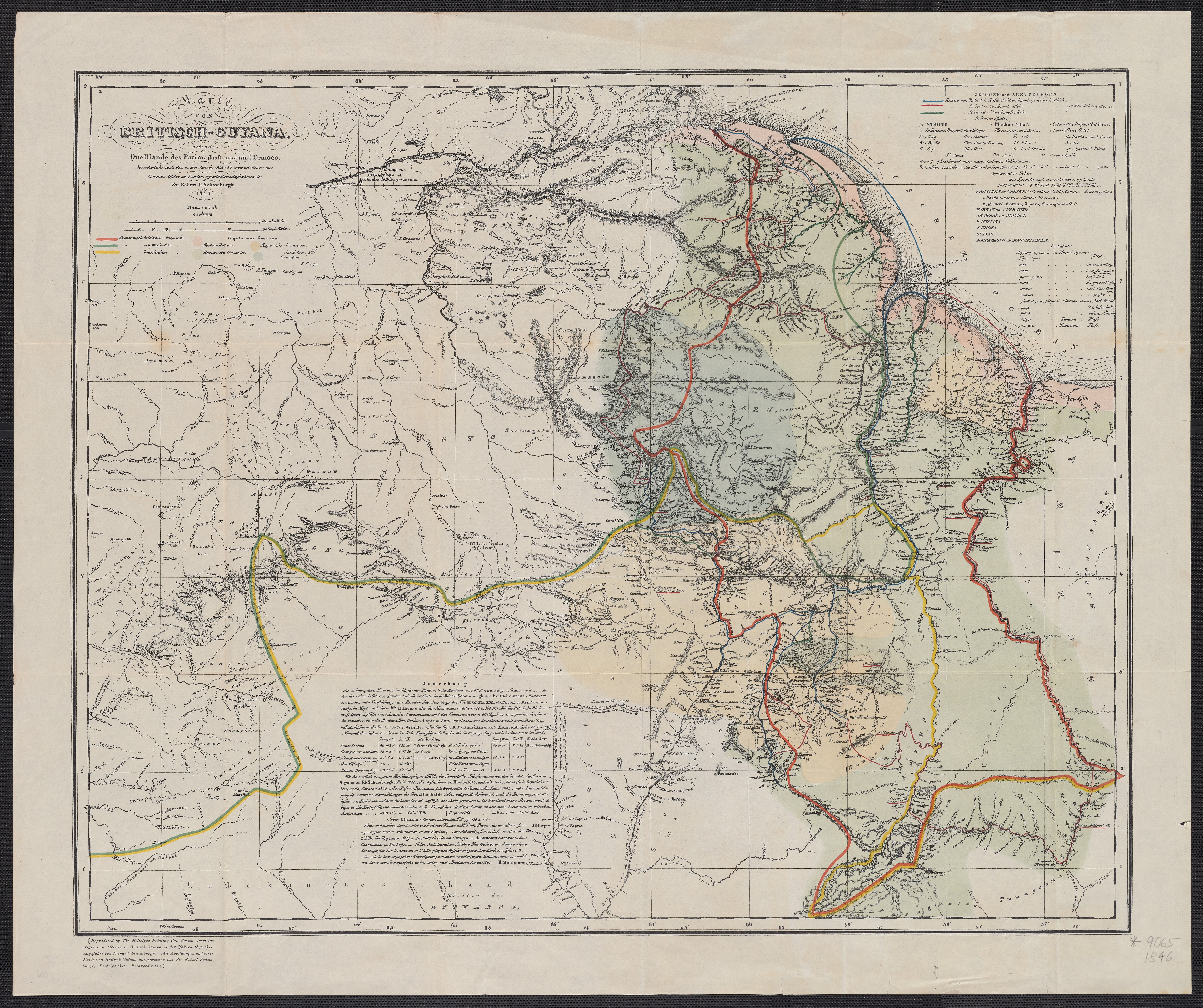
Karte von BRITISCH ~ GUYANA;nebst dem Quelllande des Prima (Rio Branco) und Orinoco

  • SCHOMBURGK;ROBERT H.

Publicado: 1846

  • Descargar Imágen
  • Descargar Imágen
Mapa 1835 - 1844

Karte von BRITISCH ~ GUYANA;nebst dem Quelllande des Prima (Rio Branco) und Orinoco

  • SCHOMBURGK;ROBERT H.

Publicado: 1846

  • Descargar Imágen

Pueblos

  • MARIUSA
  • GUARUANA
  • AWARAK
  • WARAO
  • WAIKAS
  • AKAWAIO
  • CARIBE
  • GUAYANAS
  • AYANOS
  • ENEPA
  • TAPARITAS
  • PEMON
  • CACHIRIGOTOS
  • ARNACOTO
  • CADUPINAPOS
  • GUINAUS
  • YEKUANA
  • PARIME
  • GUAINARES
  • MAUITSIS
  • MAIONGEONG
  • PURIGOTOS
  • MAKUSHI
  • WAIYAMARA
  • ZAPARA
  • KIRISHANA
  • MAKU
  • GUAICAS
  • ABERIANA
  • CURUCHIPANOS
  • CURIARANAS
  • GUAHARIBOS
  • COROTOS
  • TAPIRAS
  • CUNIPASANAS
  • MAROON NEGER
  • PAUISCHANA
  • APISIAN
  • ATORAI
  • DAURAI
  • ARUMA
  • PIANOGHOTO
  • MAOPITYAN
  • TAUAYANNA
  • PAPOGHOTTO

Citas

Schomburgk;Robert H. Karte von British - Guyana;nebst dem Quelllande des Prima (Rio Branco) und Orinoco. Map. Berlin: Heliotype Printing Co.;1846. Accessed March 3;2023. https://collections.library.yale.edu/catalog/15821075.
  • Descargar Imágen

Artículos Relacionados

Carte de la Guyane et des territoires limitrophes (Traité d'arbitrage, signé à Londres le 6 novembre 1901)

Carte de la Guyane et des territoires limitrophes (Traité d'arbitrage, signé à Londres le 6 novembre 1901)

Mapa 1900 - 1999
Santa Cruz

Santa Cruz

Mapa 1997
Major Places of Mayo Settlement

Major Places of Mayo Settlement

Mapa 1969
Carte des colonies Française et Hollandaise de la Guyane Dressée d'après les cartes de N. Buache et de S. Mentelle Capitaine d'Infanterie

Carte des colonies Française et Hollandaise de la Guyane Dressée d'après les cartes de N. Buache et de S. Mentelle Capitaine d'Infanterie

Mapa 1800 - 1899
MAPA DE COATLINCHAN/ MAP OF COALINCHAN

MAPA DE COATLINCHAN/ MAP OF COALINCHAN

Mapa 1500 - 1599
Map of the basin of La Plata : based upon the results of the expedition under the command of Thos. J. Page;U.S. Navy;in the years 1853;-'54;-'55;& 56 and of the adjacent countries

Map of the basin of La Plata : based upon the results of the expedition under the command of Thos. J. Page;U.S. Navy;in the years 1853;-'54;-'55;& 56 and of the adjacent countries

Mapa 1853 - 1856
Mapa de la Isla de Cuba y tierras circunvecinas según la división de los naturales con las derrotas que siguió el Almirante Cristóbal Colón para servir de ilustración a su historia antigua

Mapa de la Isla de Cuba y tierras circunvecinas según la división de los naturales con las derrotas que siguió el Almirante Cristóbal Colón para servir de ilustración a su historia antigua

Mapa 1500 - 1599
Lamento Guaraní

Lamento Guaraní

Obra de Arte

Despojos en las Américas

Un Proyecto de

University of Pennsylvania

Copyright 2024

Con el apoyo de

Mellon Foundation

Diseño y Desarrollo del Sitio

Element 84

Créditos Artísticos

Schomburgk;Robert H. Karte von British - Guyana;nebst dem Quelllande des Prima (Rio Branco) und Orinoco. Map. Berlin: Heliotype Printing Co.;1846. Accessed March 3;2023. https://collections.library.yale.edu/catalog/15821075.
Páginas del Sitio

  • Inicio
  • Explorar
  • Autores
  • Sobre
  • Arte
  • Cuerpos
  • Planes de Estudio
  • Herencia Cultural
  • Mapas
  • Territorios