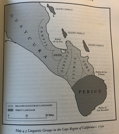
Dispossesions in the Americas

Dispossesions in the Americas

  • Inicio
  • Explorar
  • Autores
  • Sobre
  • Arte
  • Cuerpos
  • Planes de Estudio
  • Herencia Cultural
  • Mapas
  • Territorios
Volver a Explorar

Leyendo en Inglés

Mapa 1896

Sketch map of part of RÍO ORINOCO and RIO CUCHIVERO from a survey by MAJOR STANLEY PATERSON

    Publicado: 1899

    • Descargar Imágen
    • Descargar Imágen
    Mapa 1896

    Sketch map of part of RÍO ORINOCO and RIO CUCHIVERO from a survey by MAJOR STANLEY PATERSON

      Publicado: 1899

      • Descargar Imágen

      Pueblos

      • ENEPA
      • TAPARITAS

      Citas

      "Sketch map of part of Rio Orinoco and Rio Cuchivero from a survey by Major Stanley Paterson." Map. In The Geographical Journal. London: Royal Geographical Society;1899. Accessed February 26;2023. https://www.themaphouse.com/search_getamap.aspx?id=129676&ref=SAM3271.

      • Descargar Imágen

      Artículos Relacionados

      Colombia Indígena - ONIC

      Colombia Indígena - ONIC

      Mapa 2015
      MAPA LOCAL DE TOCHPAN

      MAPA LOCAL DE TOCHPAN

      Mapa 1400 - 1499
      Mapa de la zona comprendida entre los rios Paraguay y Parana, con el noreste de Argentina y sur de Brasil

      Mapa de la zona comprendida entre los rios Paraguay y Parana, con el noreste de Argentina y sur de Brasil

      Mapa 1786 - 1791
      Geographic Distribution of the Trique

      Geographic Distribution of the Trique

      Mapa 1969
      CARTE GÉOGRAPHIQUE, STATISTIQUE, HISTORIQUE ET POLITIQUE DU BRÉSIL

      CARTE GÉOGRAPHIQUE, STATISTIQUE, HISTORIQUE ET POLITIQUE DU BRÉSIL

      Mapa 1826
      "Territorio Indígena Cabécar de Ujarrás"

      "Territorio Indígena Cabécar de Ujarrás"

      Mapa 2010
      Croquis de la Laguna de Nicaragua

      Croquis de la Laguna de Nicaragua

      Mapa 1784
      CARTE DES REPUBLIQUES DE L'EQUATEUR;DE COLOMBIE;DE VENEZUELA;ET GUYANES FRANCAISE;HOLLANDAISE;ET ANGLAISE

      CARTE DES REPUBLIQUES DE L'EQUATEUR;DE COLOMBIE;DE VENEZUELA;ET GUYANES FRANCAISE;HOLLANDAISE;ET ANGLAISE

      Mapa 1875

      Despojos en las Américas

      Un Proyecto de

      University of Pennsylvania

      Copyright 2024

      Con el apoyo de

      Mellon Foundation

      Diseño y Desarrollo del Sitio

      Element 84

      Créditos Artísticos

      “Sketch map of part of Rio Orinoco and Rio Cuchivero from a survey by Major Stanley Paterson.” Map. In The Geographical Journal. London: Royal Geographical Society;1899. Accessed February 26;2023. https://www.themaphouse.com/search_getamap.aspx?id=129676&ref=SAM3271.

      Páginas del Sitio

      • Inicio
      • Explorar
      • Autores
      • Sobre
      • Arte
      • Cuerpos
      • Planes de Estudio
      • Herencia Cultural
      • Mapas
      • Territorios