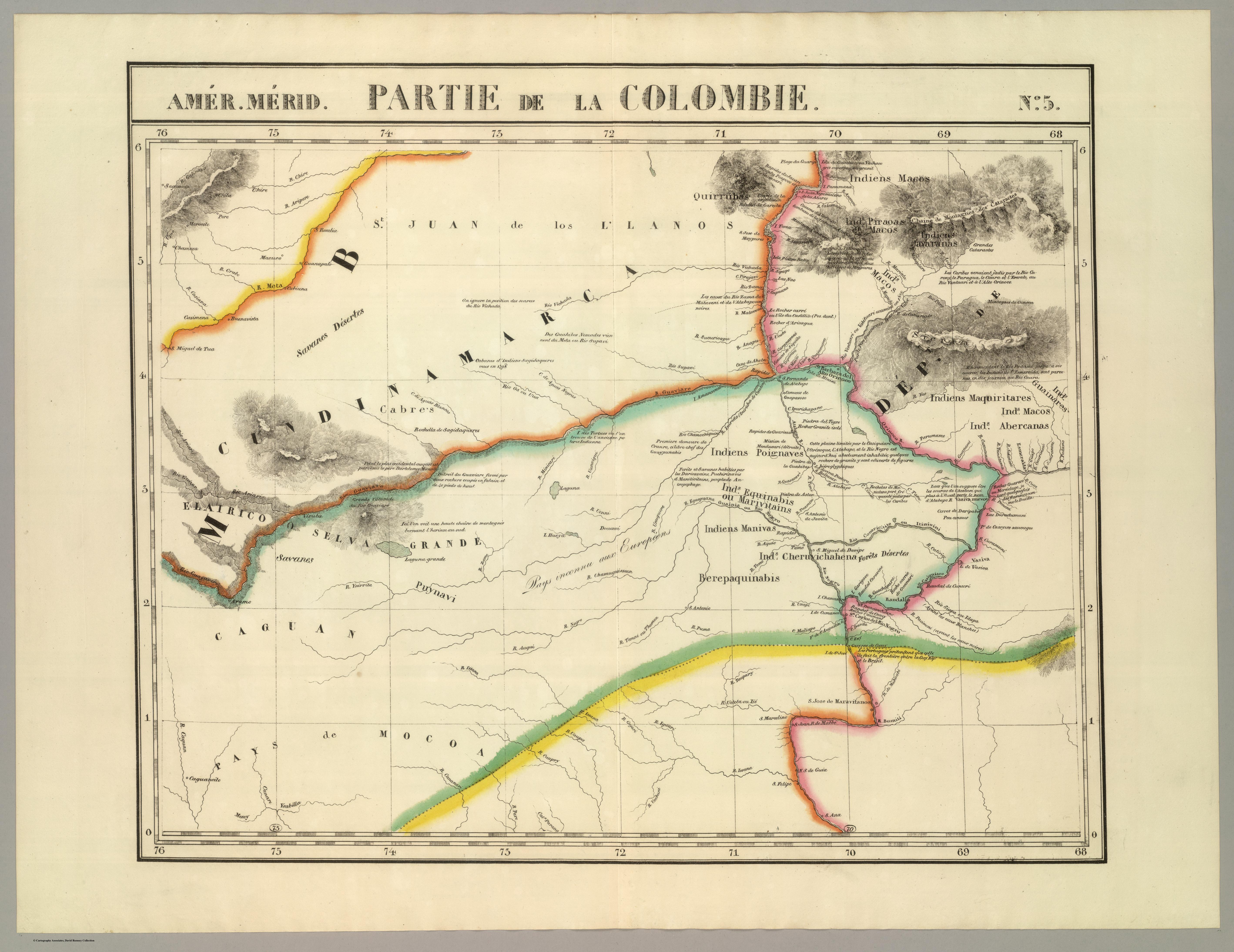
Dispossesions in the Americas

Dispossesions in the Americas

  • Inicio
  • Explorar
  • Autores
  • Sobre
  • Arte
  • Cuerpos
  • Planes de Estudio
  • Herencia Cultural
  • Mapas
  • Territorios
Volver a Explorar

Leyendo en Inglés

Mapa 1827

PARTIE DE LA COLOMBIE

  • VANDERMAELEN;PHILIPPE

Publicado: 1827

  • Descargar Imágen
  • Descargar Imágen
Mapa 1827

PARTIE DE LA COLOMBIE

  • VANDERMAELEN;PHILIPPE

Publicado: 1827

  • Descargar Imágen

Pueblos

  • QUIRRUBAS
  • MACOS
  • PIAROA
  • YAVARANA
  • CARIBE
  • CABERRE
  • YEKUANA
  • GUAINARES
  • ABERIANA
  • CHERUVICHAGENA
  • BEREPAQUINABIS
  • PUYNAVI
  • POIGNAVES
  • EQUINABIS
  • MARIVITAINS
  • MANIVAS

Citas

Vandermaelen;Philippe. Partie de la Colombie. Amer. Merid. no. 5. Map. Brussels: Ph. Vandermaelen;1827. Accessed December 28;2022. https://www.davidrumsey.com/luna/servlet/detail/RUMSEY~8~1~25244~5500104:Partie%2C-Colombie--Amer--Merid--5-?sort=pub_list_no_initialsort%2Cpub_date%2Cpub_list_no%2Cseries_no&qvq=w4s:/where%2FVenezuela;q:venezuela;sort:pub_list_no_initialsort%2Cpub_date%2Cpub_list_no%2Cseries_no;lc:RUMSEY~8~1&mi=169&trs=267#.

  • Descargar Imágen

Artículos Relacionados

"Territorios Indígenas de Costa Rica"

"Territorios Indígenas de Costa Rica"

Mapa 2010
Mapa De Las Lenguas Indigenas Actuales De Guatemala, Compilado Por A. Goubaud Carrera Y A. Arriaga;Seminario De Integracion Social

Mapa De Las Lenguas Indigenas Actuales De Guatemala, Compilado Por A. Goubaud Carrera Y A. Arriaga;Seminario De Integracion Social

Mapa 1964
PUEBLOS QUECHUAS

PUEBLOS QUECHUAS

Mapa 2021
Pueblos Indios del Norte Chico y Zona Central de Chile en el Siglo XVI y XVII

Pueblos Indios del Norte Chico y Zona Central de Chile en el Siglo XVI y XVII

Mapa 1500 - 1600
Pueblos Taínos

Pueblos Taínos

Mapa 2000 - 2015
CASIQUIARE;RIO ATABAPO;ET COURS INFERIEUR DE I’YNIRIDA

CASIQUIARE;RIO ATABAPO;ET COURS INFERIEUR DE I’YNIRIDA

Mapa 1872 - 1876
NATIVE RACES of the PACIFIC STATES

NATIVE RACES of the PACIFIC STATES

Mapa 1800
Map of the Ucayali River

Map of the Ucayali River

Mapa 1808 - 1812

Despojos en las Américas

Un Proyecto de

University of Pennsylvania

Copyright 2024

Con el apoyo de

Mellon Foundation

Diseño y Desarrollo del Sitio

Element 84

Créditos Artísticos

Vandermaelen;Philippe. Partie de la Colombie. Amer. Merid. no. 5. Map. Brussels: Ph. Vandermaelen;1827. Accessed December 28;2022. https://www.davidrumsey.com/luna/servlet/detail/RUMSEY~8~1~25244~5500104:Partie%2C-Colombie--Amer--Merid--5-?sort=pub_list_no_initialsort%2Cpub_date%2Cpub_list_no%2Cseries_no&qvq=w4s:/where%2FVenezuela;q:venezuela;sort:pub_list_no_initialsort%2Cpub_date%2Cpub_list_no%2Cseries_no;lc:RUMSEY~8~1&mi=169&trs=267#.

Páginas del Sitio

  • Inicio
  • Explorar
  • Autores
  • Sobre
  • Arte
  • Cuerpos
  • Planes de Estudio
  • Herencia Cultural
  • Mapas
  • Territorios