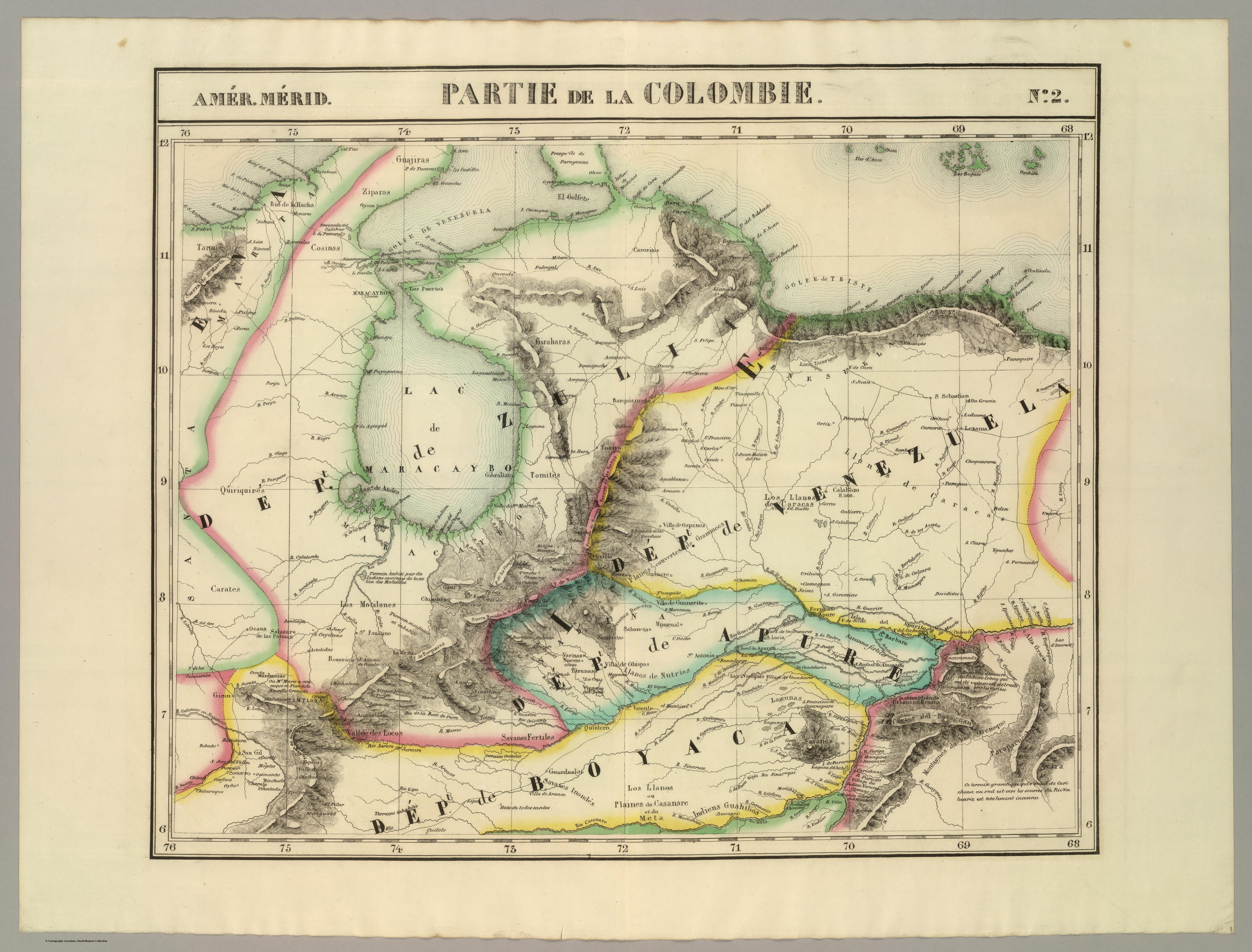
Dispossesions in the Americas

Dispossesions in the Americas

  • Inicio
  • Explorar
  • Autores
  • Sobre
  • Arte
  • Cuerpos
  • Planes de Estudio
  • Herencia Cultural
  • Mapas
  • Territorios
Volver a Explorar

Leyendo en Inglés

Mapa 1827

PARTIE DE LA COLOMBIE

  • VANDERMAELEN;PHILIPPE

Publicado: 1827

  • Descargar Imágen
  • Descargar Imágen
Mapa 1827

PARTIE DE LA COLOMBIE

  • VANDERMAELEN;PHILIPPE

Publicado: 1827

  • Descargar Imágen

Pueblos

  • JIVI
  • ZAPARA
  • COSINAS
  • JIRAJARA
  • QUIRIQUIRES
  • TIMOTE
  • BARI
  • AVIRA
  • PARAPARUCOTA
  • GUAHIVAS
  • TARONAS
  • CARATES

Cita

Vandermaelen;Philippe. Partie de la Colombie. Amer. Merid. no. 2. Map. Brussels: Ph. Vandermaelen;1827. Accessed December 27;2022. https://www.davidrumsey.com/luna/servlet/detail/RUMSEY~8~1~25240~5500100:Partie%2C-Colombie--Amer--Merid--2-?sort=pub_list_no_initialsort%2Cpub_date%2Cpub_list_no%2Cseries_no&qvq=w4s:/where%2FVenezuela;q:venezuela;sort:pub_list_no_initialsort%2Cpub_date%2Cpub_list_no%2Cseries_no;lc:RUMSEY~8~1&mi=167&trs=267#.

  • Descargar Imágen

Leyendo en Portugués

Mapa 1827

PARTIE DE LA COLOMBIE

  • VANDERMAELEN;PHILIPPE

Publicado: 1827

  • Descargar Imágen

Pueblos

  • JIVI
  • ZAPARA
  • COSINAS
  • JIRAJARA
  • QUIRIQUIRES
  • TIMOTE
  • BARI
  • AVIRA
  • PARAPARUCOTA
  • GUAHIVAS
  • TARONAS
  • CARATES

Cita

Vandermaelen;Philippe. Partie de la Colombie. Amer. Merid. no. 2. Map. Brussels: Ph. Vandermaelen;1827. Accessed December 27;2022. https://www.davidrumsey.com/luna/servlet/detail/RUMSEY~8~1~25240~5500100:Partie%2C-Colombie--Amer--Merid--2-?sort=pub_list_no_initialsort%2Cpub_date%2Cpub_list_no%2Cseries_no&qvq=w4s:/where%2FVenezuela;q:venezuela;sort:pub_list_no_initialsort%2Cpub_date%2Cpub_list_no%2Cseries_no;lc:RUMSEY~8~1&mi=167&trs=267#.

  • Descargar Imágen

Artículos Relacionados

[Cartes de S. Domingue, de Cuba, de la Martinique et de la Guadeloupe]

[Cartes de S. Domingue, de Cuba, de la Martinique et de la Guadeloupe]

Mapa 1700 - 1799
The Tarahumar Country, 1959

The Tarahumar Country, 1959

Mapa 1959
Map of the basin of La Plata : based upon the results of the expedition under the command of Thos. J. Page;U.S. Navy;in the years 1853;-'54;-'55;& 56 and of the adjacent countries

Map of the basin of La Plata : based upon the results of the expedition under the command of Thos. J. Page;U.S. Navy;in the years 1853;-'54;-'55;& 56 and of the adjacent countries

Mapa 1853 - 1856
PUEBLO NAHUA DEL EDO DE MEXICO

PUEBLO NAHUA DEL EDO DE MEXICO

Mapa 2020
Risaralda

Risaralda

Mapa 2012
America noviter delineata

America noviter delineata

Mapa 1600 - 1699
N. 100. Carte de la Guyane Française

N. 100. Carte de la Guyane Française

Mapa 1878
MICHOACÁN

MICHOACÁN

Mapa 2015

Despojos en las Américas

Un Proyecto de

University of Pennsylvania

Copyright 2024

Con el apoyo de

Mellon Foundation

Diseño y Desarrollo del Sitio

Element 84

Créditos Artísticos

Vandermaelen;Philippe. Partie de la Colombie. Amer. Merid. no. 2. Map. Brussels: Ph. Vandermaelen;1827. Accessed December 27;2022. https://www.davidrumsey.com/luna/servlet/detail/RUMSEY~8~1~25240~5500100:Partie%2C-Colombie--Amer--Merid--2-?sort=pub_list_no_initialsort%2Cpub_date%2Cpub_list_no%2Cseries_no&qvq=w4s:/where%2FVenezuela;q:venezuela;sort:pub_list_no_initialsort%2Cpub_date%2Cpub_list_no%2Cseries_no;lc:RUMSEY~8~1&mi=167&trs=267#.

Páginas del Sitio

  • Inicio
  • Explorar
  • Autores
  • Sobre
  • Arte
  • Cuerpos
  • Planes de Estudio
  • Herencia Cultural
  • Mapas
  • Territorios