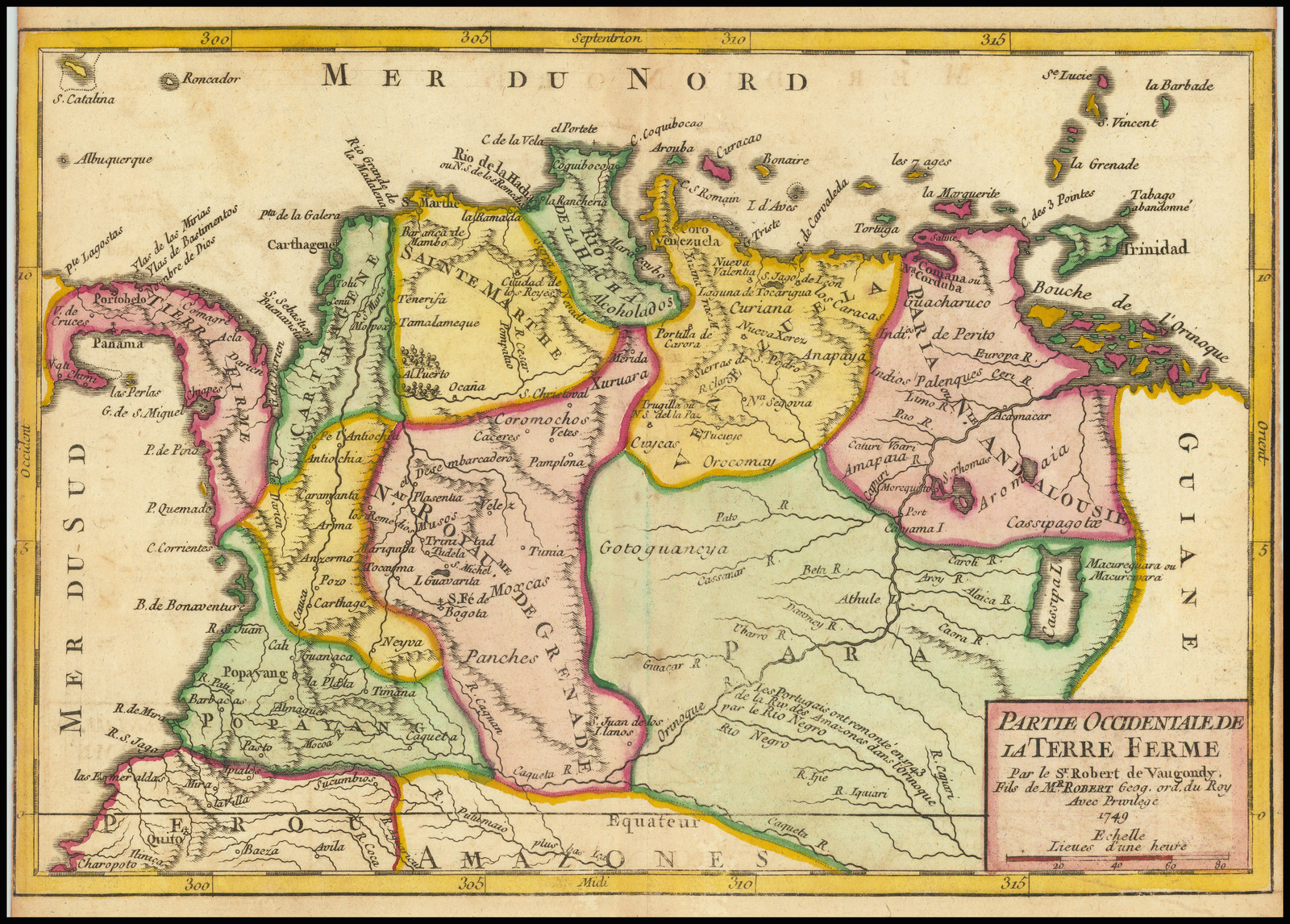
Dispossesions in the Americas

Dispossesions in the Americas

  • Inicio
  • Explorar
  • Autores
  • Sobre
  • Arte
  • Cuerpos
  • Planes de Estudio
  • Herencia Cultural
  • Mapas
  • Territorios
Volver a Explorar

Leyendo en Inglés

Mapa 1749

Partie Occidentale de la Terre Ferme

  • ROBERT DE VAUGONDY;GILLES

Publicado: 1749

  • Descargar Imágen
  • Descargar Imágen
Mapa 1749

Partie Occidentale de la Terre Ferme

  • ROBERT DE VAUGONDY;GILLES

Publicado: 1749

  • Descargar Imágen

Pueblos

  • PALENQUES
  • INDIOS DE PERITO
  • CASSIPAGOTOS
  • OROCOMAY
  • COROMOCHOS
  • CUICA
  • PANCHES
  • MOXCAS
  • XURUARA

Cita

Robert de Vaugondy;Gilles. Partie Occidentale de la Terre Ferme. Map. Paris;1749. Accessed August 28;2022. https://www.raremaps.com/gallery/detail/70913/partie-occidentale-de-la-terre-ferme-1749-de-vaugondy.

  • Descargar Imágen

Leyendo en Portugués

Mapa 1749

Partie Occidentale de la Terre Ferme

  • ROBERT DE VAUGONDY;GILLES

Publicado: 1749

  • Descargar Imágen

Pueblos

  • PALENQUES
  • INDIOS DE PERITO
  • CASSIPAGOTOS
  • OROCOMAY
  • COROMOCHOS
  • CUICA
  • PANCHES
  • MOXCAS
  • XURUARA

Cita

Robert de Vaugondy;Gilles. Partie Occidentale de la Terre Ferme. Map. Paris;1749. Accessed August 28;2022. https://www.raremaps.com/gallery/detail/70913/partie-occidentale-de-la-terre-ferme-1749-de-vaugondy.

  • Descargar Imágen

Artículos Relacionados

Mapa de la Republica de Guatemala, America Central

Mapa de la Republica de Guatemala, America Central

Mapa 1880 - 1900
Govierno de Venezuela;1758.

Govierno de Venezuela;1758.

Mapa 1758
FAMILIAS LINGUÍSTICAS Y LENGUAS INDÍGENAS. OCTAVA REGION: PENINSULA DE LA GUAJIRA

FAMILIAS LINGUÍSTICAS Y LENGUAS INDÍGENAS. OCTAVA REGION: PENINSULA DE LA GUAJIRA

Mapa 1989
PUEBLO NAHUA DE TLAXCALA

PUEBLO NAHUA DE TLAXCALA

Mapa 2020
Map representing the linguistic diversity that existed in Central America and the Gulf of Fonseca at the time of contact with the Spanish

Map representing the linguistic diversity that existed in Central America and the Gulf of Fonseca at the time of contact with the Spanish

Mapa 1522
Geographical Distribution of the Cuicatec

Geographical Distribution of the Cuicatec

Mapa 1969
BRASIL

BRASIL

Mapa 1835
Carte du Gouvernement de Cayenne.

Carte du Gouvernement de Cayenne.

Mapa 1700 - 1799

Despojos en las Américas

Un Proyecto de

University of Pennsylvania

Copyright 2024

Con el apoyo de

Mellon Foundation

Diseño y Desarrollo del Sitio

Element 84

Créditos Artísticos

Robert de Vaugondy;Gilles. Partie Occidentale de la Terre Ferme. Map. Paris;1749. Accessed August 28;2022. https://www.raremaps.com/gallery/detail/70913/partie-occidentale-de-la-terre-ferme-1749-de-vaugondy.

Páginas del Sitio

  • Inicio
  • Explorar
  • Autores
  • Sobre
  • Arte
  • Cuerpos
  • Planes de Estudio
  • Herencia Cultural
  • Mapas
  • Territorios