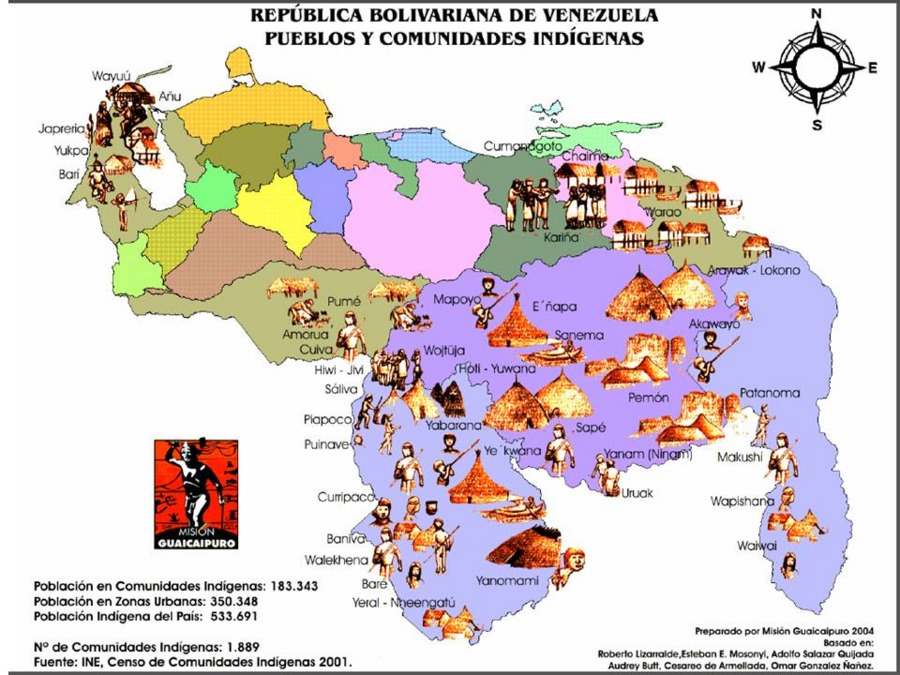
Dispossesions in the Americas

Dispossesions in the Americas

  • Inicio
  • Explorar
  • Autores
  • Sobre
  • Arte
  • Cuerpos
  • Planes de Estudio
  • Herencia Cultural
  • Mapas
  • Territorios
Volver a Explorar

Leyendo en Inglés

Mapa 2004

REPÚBLICA BOLIVARIANA DE VENEZUELA PUEBLOS Y COMUNIDADES INDÍGENAS

  • MISION GUAICAIPURO

Publicado: 2004

  • Descargar Imágen
  • Descargar Imágen
Mapa 2004

REPÚBLICA BOLIVARIANA DE VENEZUELA PUEBLOS Y COMUNIDADES INDÍGENAS

  • MISION GUAICAIPURO

Publicado: 2004

  • Descargar Imágen

Pueblos

  • AKAWAIO
  • AMORUA
  • ANUU
  • ARAWAK
  • BANIVA
  • BARE
  • BARI
  • CHAIMA
  • KUIVA
  • KUMANAGOTO
  • ENEPA
  • HOTI
  • JAPRERIA
  • JIVI
  • KARINA
  • MAKUSHI
  • MAPOYO
  • PATAMONA
  • PEMON
  • PIAPOCO
  • PIAROA
  • PUINAVE
  • YARURO
  • SALIVA
  • SANEMA
  • SAPE
  • URUAK WAIWAI
  • WAKUENAI
  • WAREKHENA
  • WAPISHANA
  • WARAO
  • WAYUU
  • YAVARANA
  • YANAM
  • YANOMAMI
  • YEKUANA
  • YERAL
  • YUKPA

Citas

Mission Guaicaipuro. "República Bolivariana de Venezuela pueblos y comunidades indígenas." Map. Native Lands. 2004. Accessed March 13;2022. https://i0.wp.com/native-land.ca/wp-content/uploads/2020/04/Naciones-Indigenas.png?fit=960%2C720&ssl=1.

  • Descargar Imágen

Artículos Relacionados

A Map of part of Yucatan or of that Part of the Eastern Shore Within the Bay of Honduras Alloted to Great Britain for the Cutting of Logwood, in consequence of the Convention Signed with Spain on the 14th July 1786.

A Map of part of Yucatan or of that Part of the Eastern Shore Within the Bay of Honduras Alloted to Great Britain for the Cutting of Logwood, in consequence of the Convention Signed with Spain on the 14th July 1786.

Mapa 1700
Pueblo de Soacha

Pueblo de Soacha

Mapa 1627
INTENDENCIA DE TABASCO

INTENDENCIA DE TABASCO

Mapa 1800
COLOMBIA AND GUIANA

COLOMBIA AND GUIANA

Mapa 1830
Mapa de la República de Guatemala

Mapa de la República de Guatemala

Mapa 1800 - 1900
NEW GRANADA

NEW GRANADA

Mapa 1811
La France équinoctiale remise soubs l'Obeissance du Roy en l'année 1664.

La France équinoctiale remise soubs l'Obeissance du Roy en l'année 1664.

Mapa 1664
No nos culpes por lo que pasó

No nos culpes por lo que pasó

Obra de Arte

Despojos en las Américas

Un Proyecto de

University of Pennsylvania

Copyright 2024

Con el apoyo de

Mellon Foundation

Diseño y Desarrollo del Sitio

Element 84

Créditos Artísticos

Mission Guaicaipuro. “República Bolivariana de Venezuela pueblos y comunidades indígenas.” Map. Native Lands. 2004. Accessed March 13;2022. https://i0.wp.com/native-land.ca/wp-content/uploads/2020/04/Naciones-Indigenas.png?fit=960%2C720&ssl=1.

Páginas del Sitio

  • Inicio
  • Explorar
  • Autores
  • Sobre
  • Arte
  • Cuerpos
  • Planes de Estudio
  • Herencia Cultural
  • Mapas
  • Territorios