Dispossesions in the Americas

Dispossesions in the Americas

  • Inicio
  • Explorar
  • Autores
  • Sobre
  • Arte
  • Cuerpos
  • Planes de Estudio
  • Herencia Cultural
  • Mapas
  • Territorios
Volver a Explorar

Leyendo en Inglés

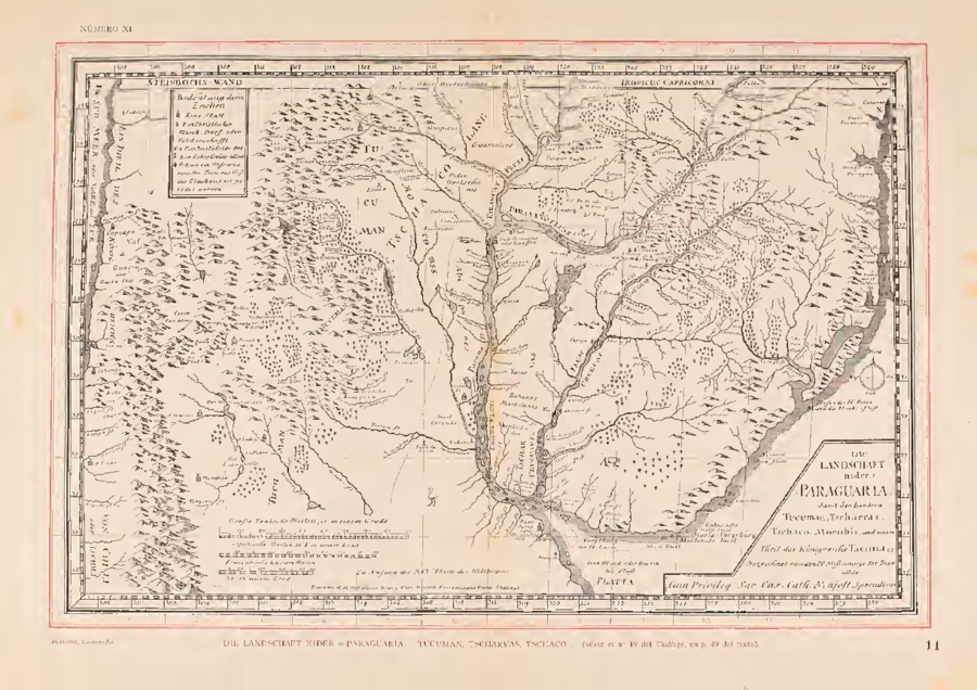
Mapa 1728

Die LANDSCHAFT nider = Paraguaria

  • DIETELL, CHRISTOPH

Publicado: 1728

  • Descargar Imágen
  • Descargar Imágen
Mapa 1728

Die LANDSCHAFT nider = Paraguaria

  • DIETELL, CHRISTOPH

Publicado: 1728

  • Descargar Imágen

Pueblos

  • YAROS
  • MARTIDANES
  • BOHANES
  • MANCHADOS
  • ABIPONES
  • MOCOVI
  • ORECHONES
  • GUAMALCAS
  • ORECHONES
  • FRENTONES
  • PALOMOS
  • GUIPIOAS
  • OCLOVAS
  • MARACAYU
  • YERBALES

Citas

Dietell, Christoph. Die Landschaft nider=Paraguaria, Samt den Ländern Tucuman, Tscharvas, Tschaco, Mocobis, und einem Theil des Königreichs Tschili. Map. Augsburg & Graz: Heirs of Phillip, Martin & Johann Veith, 1728. https://jcb.lunaimaging.com/luna/servlet/detail/JCBMAPS~1~1~2190~109790004:Die-Landschaft-nider%3DParaguaria%2C-Sa%3Fsort%3DDate%252CTitle?qvq=w4s:/who%2FGraecij%2F%255BHeirs%2Bof%2BPhillip%2C%2BMartin%2B%26%2BJohann%2BVeith%255D%2Fwhere%2FSouth%2BAmerica;sort:Date%2CTitle&mi=1&trs=2.
  • Descargar Imágen

Artículos Relacionados

Indigenous provinces in El Salvador around 1500. (Adapted from Fowler 1989140-141, figure 5, with additional information from Lehman 1920:719, with modifications by the author.)

Indigenous provinces in El Salvador around 1500. (Adapted from Fowler 1989140-141, figure 5, with additional information from Lehman 1920:719, with modifications by the author.)

Mapa 1500
CARTA ETNOGRÁFICA

CARTA ETNOGRÁFICA

Mapa 1885
Laguna de Nicaragua

Laguna de Nicaragua

Mapa 1784
Côtes du Brésil de Bahia de todos los Sancts à Spirito Santo

Côtes du Brésil de Bahia de todos los Sancts à Spirito Santo

Mapa 1779
BRASILIA ET PERUVIA

BRASILIA ET PERUVIA

Mapa 1500 - 1599
Mapa de las tierras indígenas - Pueblos

Mapa de las tierras indígenas - Pueblos

Mapa 2017
d'Engelze Volkplanting in't Amerikaans gewest Gujana, en Rio de las Amazones

d'Engelze Volkplanting in't Amerikaans gewest Gujana, en Rio de las Amazones

Mapa 1700 - 1799
Plan de la Mission de Kourou et de ses Environs dans lequel on voit l'Etat dans lequel étoit le pays lors de l'arrivée de Monsieur de Préfontaine le 17 juillet 1763

Plan de la Mission de Kourou et de ses Environs dans lequel on voit l'Etat dans lequel étoit le pays lors de l'arrivée de Monsieur de Préfontaine le 17 juillet 1763

Mapa 1763

Despojos en las Américas

Un Proyecto de

University of Pennsylvania

Copyright 2024

Con el apoyo de

Mellon Foundation

Diseño y Desarrollo del Sitio

Element 84

Créditos Artísticos

Dietell, Christoph. Die Landschaft nider=Paraguaria, Samt den Ländern Tucuman, Tscharvas, Tschaco, Mocobis, und einem Theil des Königreichs Tschili. Map. Augsburg & Graz: Heirs of Phillip, Martin & Johann Veith, 1728. https://jcb.lunaimaging.com/luna/servlet/detail/JCBMAPS~1~1~2190~109790004:Die-Landschaft-nider%3DParaguaria%2C-Sa%3Fsort%3DDate%252CTitle?qvq=w4s:/who%2FGraecij%2F%255BHeirs%2Bof%2BPhillip%2C%2BMartin%2B%26%2BJohann%2BVeith%255D%2Fwhere%2FSouth%2BAmerica;sort:Date%2CTitle&mi=1&trs=2.
Páginas del Sitio

  • Inicio
  • Explorar
  • Autores
  • Sobre
  • Arte
  • Cuerpos
  • Planes de Estudio
  • Herencia Cultural
  • Mapas
  • Territorios