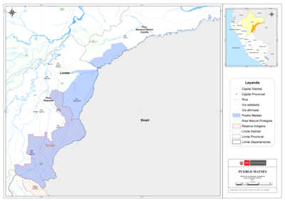
Dispossesions in the Americas

Dispossesions in the Americas

  • Inicio
  • Explorar
  • Autores
  • Sobre
  • Arte
  • Cuerpos
  • Planes de Estudio
  • Herencia Cultural
  • Mapas
  • Territorios
Volver a Explorar

Leyendo en Inglés

Mapa 1680 - 1805

Theories of Migration (Minuanes).

  • ERBIG, JEFFREY ALAN JR

Publicado: 2015

  • Descargar Imágen
  • Descargar Imágen
Mapa 1680 - 1805

Theories of Migration (Minuanes).

  • ERBIG, JEFFREY ALAN JR

Publicado: 2015

  • Descargar Imágen

Pueblos

  • MINUANES

Cita

Erbig, Jeffrey Alan, Jr. "Imperial Lines, Indigenous Lands: Transforming Territorialities of the Río de la Plata, 1680-1805." PhD diss., University of North Carolina at Chapel Hill, 2015. Accessed May 29, 2022. p. 24. https://www.jeffreyerbig.com/uploads/2/0/4/0/20408503/dissertation_erbig.pdf.

  • Descargar Imágen

Leyendo en Portugués

Mapa 1680 - 1805

Theories of Migration (Minuanes).

  • ERBIG, JEFFREY ALAN JR

Publicado: 2015

  • Descargar Imágen

Pueblos

  • MINUANES

Cita

Erbig, Jeffrey Alan, Jr. "Imperial Lines, Indigenous Lands: Transforming Territorialities of the Río de la Plata, 1680-1805." PhD diss., University of North Carolina at Chapel Hill, 2015. Accessed May 29, 2022. p. 24. https://www.jeffreyerbig.com/uploads/2/0/4/0/20408503/dissertation_erbig.pdf.

  • Descargar Imágen

Artículos Relacionados

Saweto

Saweto

Obra de Arte
“O beijo” [El beso]

“O beijo” [El beso]

Obra de Arte
Sketch of the country from reduction to Buenos Ayres, shewing the movements of B. Genl. Beresford, when he captured that place June 1806. Drawn from memorandums furnished by Capt: Donnelly

Sketch of the country from reduction to Buenos Ayres, shewing the movements of B. Genl. Beresford, when he captured that place June 1806. Drawn from memorandums furnished by Capt: Donnelly

Mapa 1806
MAP 7.—The Highland tribes of Colombia and Ecuador. (Drawn from data compiled by Gregorio Hernández de Alba;John Murra;Sergio Elías Ortíz;and Henri Lehmann.)

MAP 7.—The Highland tribes of Colombia and Ecuador. (Drawn from data compiled by Gregorio Hernández de Alba;John Murra;Sergio Elías Ortíz;and Henri Lehmann.)

Mapa 1400
A Cobra Grande manda para sua filha a noz de Tucunã [La Gran Serpiente le envía a su hija la nuez de Tucunã]

A Cobra Grande manda para sua filha a noz de Tucunã [La Gran Serpiente le envía a su hija la nuez de Tucunã]

Obra de Arte
PUEBLO MATSÉS

PUEBLO MATSÉS

Mapa 2021
CANTON de PIACOA de la PROVINCIA DE GUAYANA

CANTON de PIACOA de la PROVINCIA DE GUAYANA

Mapa 1840
MAPA de las PROVINCIAS DE VENEZUELA Y DEL REINO DE SANTA FE

MAPA de las PROVINCIAS DE VENEZUELA Y DEL REINO DE SANTA FE

Mapa 1831

Despojos en las Américas

Un Proyecto de

University of Pennsylvania

Copyright 2024

Con el apoyo de

Mellon Foundation

Diseño y Desarrollo del Sitio

Element 84

Créditos Artísticos

Erbig, Jeffrey Alan, Jr. “Imperial Lines, Indigenous Lands: Transforming Territorialities of the Río de la Plata, 1680-1805.” PhD diss., University of North Carolina at Chapel Hill, 2015. Accessed May 29, 2022. p. 24. https://www.jeffreyerbig.com/uploads/2/0/4/0/20408503/dissertation_erbig.pdf.

Páginas del Sitio

  • Inicio
  • Explorar
  • Autores
  • Sobre
  • Arte
  • Cuerpos
  • Planes de Estudio
  • Herencia Cultural
  • Mapas
  • Territorios