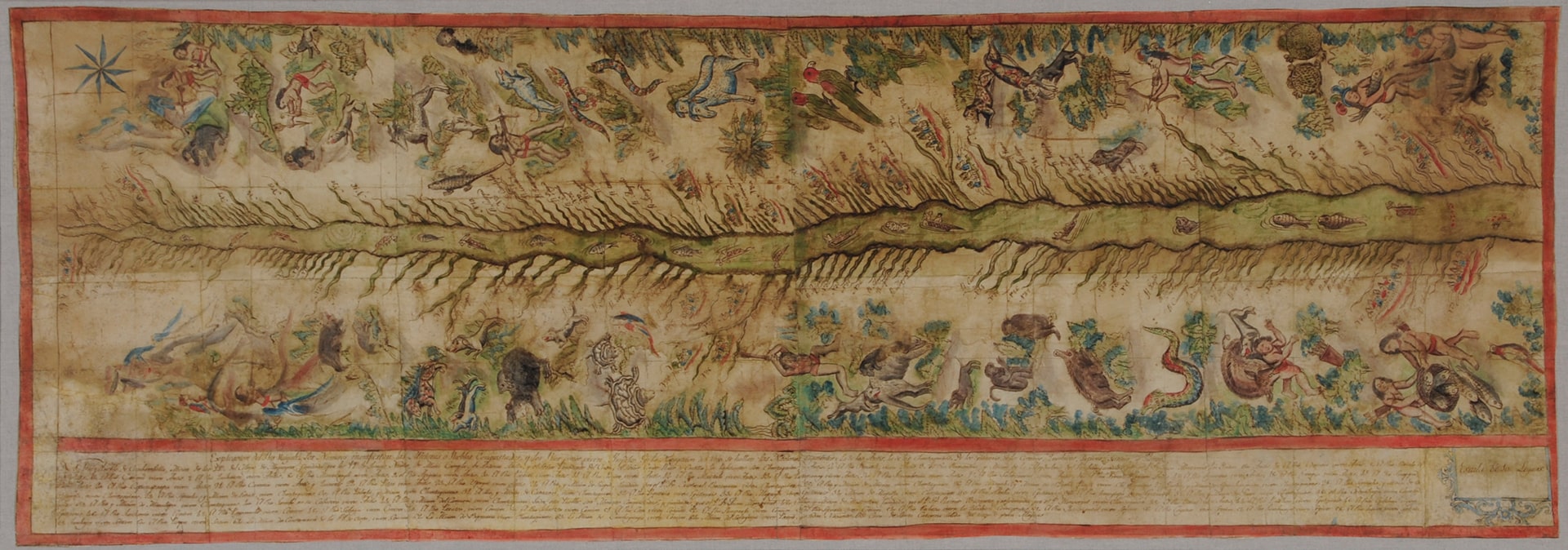
Dispossesions in the Americas

Dispossesions in the Americas

  • Inicio
  • Explorar
  • Autores
  • Sobre
  • Arte
  • Cuerpos
  • Planes de Estudio
  • Herencia Cultural
  • Mapas
  • Territorios
Volver a Explorar

Leyendo en Inglés

Mapa 1808 - 1812

Map of the Ucayali River

  • FRANCISCAN MISSIONARIES;INDIGENOUS ARTISTS

Publicado: 1812

  • Descargar Imágen
  • Descargar Imágen
Mapa 1808 - 1812

Map of the Ucayali River

  • FRANCISCAN MISSIONARIES;INDIGENOUS ARTISTS

Publicado: 1812

  • Descargar Imágen

Pueblos

  • ANTI
  • CASHIBO
  • CHONTAQUIRO
  • CONIBO
  • IPITINERI
  • PANOBO
  • SHETIBO
  • SHIPIBO

Cita

The Hispanic Society (New York), Viceregal Peru, Map of the Ucayali River. https://hispanicsociety.org/exhibition/current-exhibitions-works-on-loan/treasures-on-the-terrace_highlights-from-the-hispanic-society-museum-and-library/ucayali-river/

  • Descargar Imágen

Leyendo en Portugués

Mapa 1808 - 1812

Map of the Ucayali River

  • FRANCISCAN MISSIONARIES;INDIGENOUS ARTISTS

Publicado: 1812

  • Descargar Imágen

Pueblos

  • ANTI
  • CASHIBO
  • CHONTAQUIRO
  • CONIBO
  • IPITINERI
  • PANOBO
  • SHETIBO
  • SHIPIBO

Cita

The Hispanic Society (New York), Viceregal Peru, Map of the Ucayali River. https://hispanicsociety.org/exhibition/current-exhibitions-works-on-loan/treasures-on-the-terrace_highlights-from-the-hispanic-society-museum-and-library/ucayali-river/

  • Descargar Imágen

Artículos Relacionados

PUEBLO TLAPANECO

PUEBLO TLAPANECO

Mapa 2020
Empire du BRÉSIL

Empire du BRÉSIL

Mapa 1835
Reducción del territorio Barí 1950 -1970

Reducción del territorio Barí 1950 -1970

Mapa 1950 - 1970
SPECIAL MAP OF BRITISH GUIANA Illustrating the VENEZUELA-GUIANA BOUNDARY DISPUTE

SPECIAL MAP OF BRITISH GUIANA Illustrating the VENEZUELA-GUIANA BOUNDARY DISPUTE

Mapa 1898
The Course of the River of Amazons.

The Course of the River of Amazons.

Mapa 1600 - 1699
Carta della Guiana

Carta della Guiana

Mapa 1700 - 1799
Map of the Republic of Guatemala

Map of the Republic of Guatemala

Mapa 1800
Población es-pei (cucupá) en 2010

Población es-pei (cucupá) en 2010

Mapa 2010

Despojos en las Américas

Un Proyecto de

University of Pennsylvania

Copyright 2024

Con el apoyo de

Mellon Foundation

Diseño y Desarrollo del Sitio

Element 84

Créditos Artísticos

The Hispanic Society (New York), Viceregal Peru, Map of the Ucayali River. https://hispanicsociety.org/exhibition/current-exhibitions-works-on-loan/treasures-on-the-terrace_highlights-from-the-hispanic-society-museum-and-library/ucayali-river/

Páginas del Sitio

  • Inicio
  • Explorar
  • Autores
  • Sobre
  • Arte
  • Cuerpos
  • Planes de Estudio
  • Herencia Cultural
  • Mapas
  • Territorios