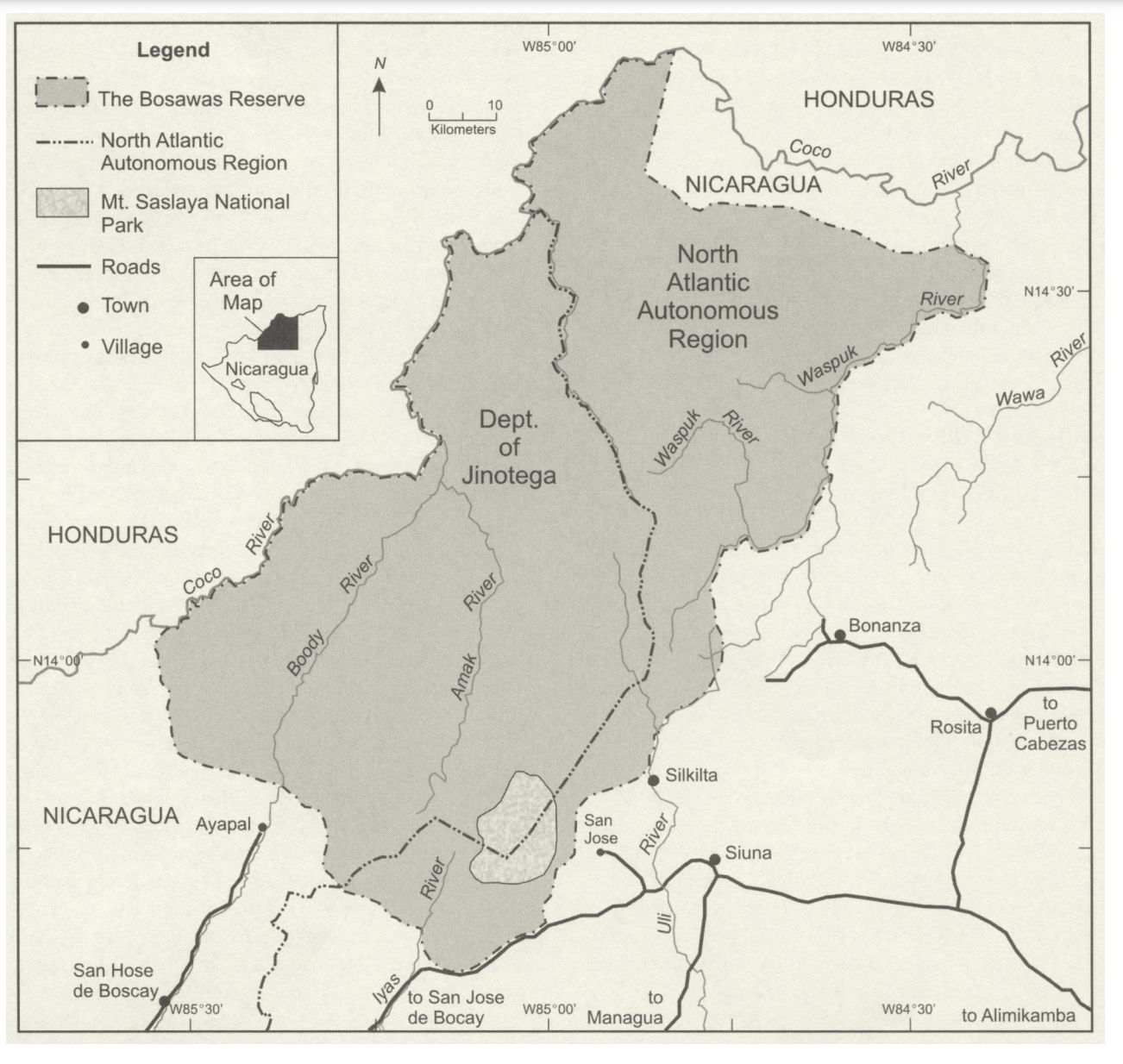
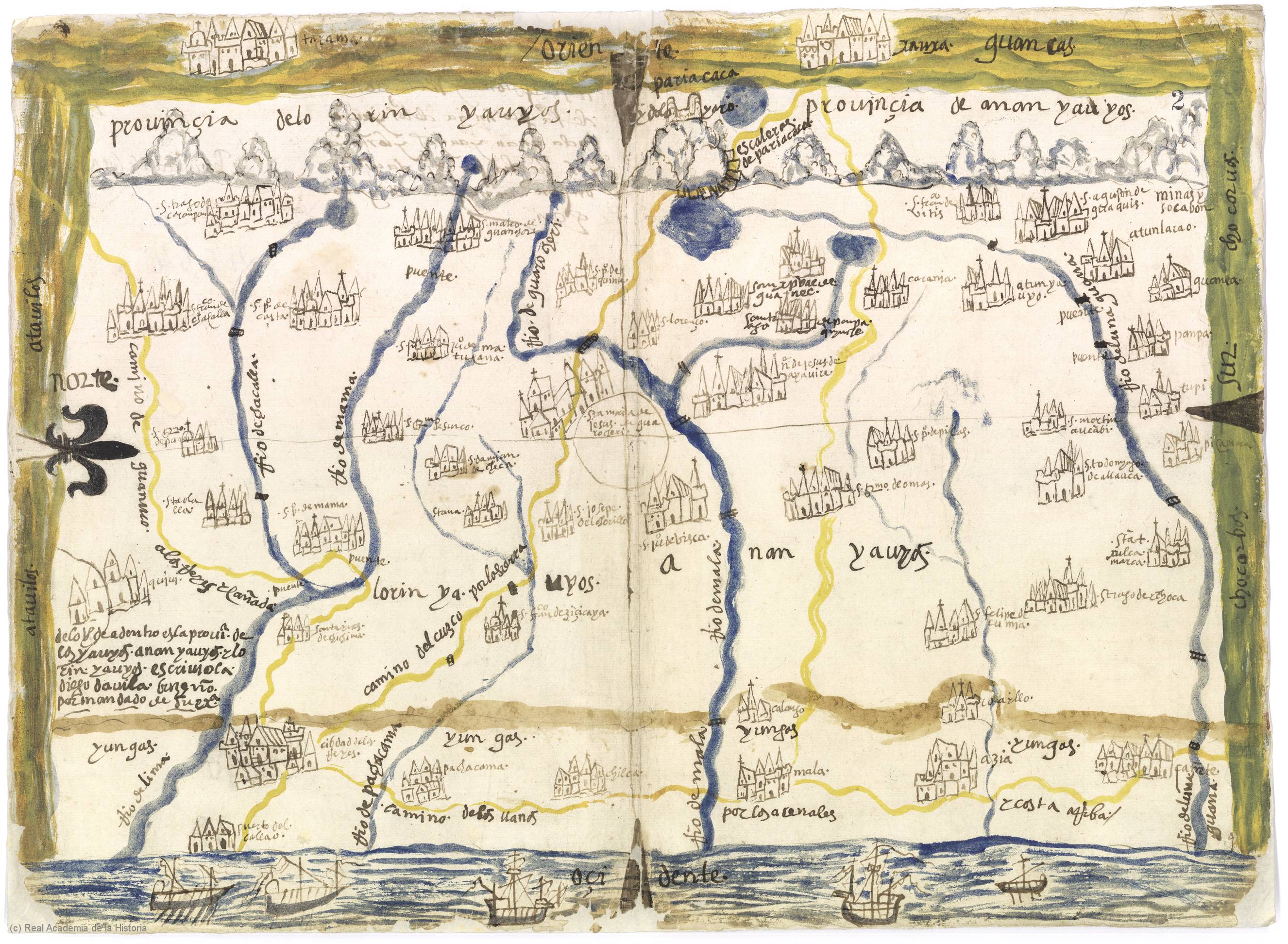
Dispossesions in the Americas

Dispossesions in the Americas

  • Inicio
  • Explorar
  • Autores
  • Sobre
  • Arte
  • Cuerpos
  • Planes de Estudio
  • Herencia Cultural
  • Mapas
  • Territorios
Volver a Explorar

Leyendo en Inglés

Mapa 1586

Provincia de Yauyos

  • Diego Dávila Briceño

Publicado: 1586

  • Descargar Imágen
  • Descargar Imágen
Mapa 1586

Provincia de Yauyos

  • Diego Dávila Briceño

Publicado: 1586

  • Descargar Imágen

Pueblos

  • ANAN-YAUYOS
  • ATAVILLOS
  • CHOCORBOS
  • GUANCAS
  • LORIN-YAUYOS
  • YUNGAS

Citas

Briceño, D. D. (Cartographer). (1586). Provincia de Yauyos [Map]. Biblioteca Digital Real Academia De La Historia. https://bibliotecadigital.rah.es/es/consulta/registro.do?control=RAH20110000332

  • Descargar Imágen

Artículos Relacionados

MAPA DE SAN MATEO IXTLAHUACAN

MAPA DE SAN MATEO IXTLAHUACAN

Mapa 1500 - 1599
Resguardo de los indios de Guateque. Plano en trazo simple de la cuchilla que pretenden los indios. Corresponde al expediente seguido por los indios con Francisco Javier del Castillo, por deslinde de tierras

Resguardo de los indios de Guateque. Plano en trazo simple de la cuchilla que pretenden los indios. Corresponde al expediente seguido por los indios con Francisco Javier del Castillo, por deslinde de tierras

Mapa 1801
CARTA DO SUL DO IMPERIO BRASIL, comprehandendo as PROVINCIAS RIO GRANDE do SUL, STA. CATHARINA e PARANA

CARTA DO SUL DO IMPERIO BRASIL, comprehandendo as PROVINCIAS RIO GRANDE do SUL, STA. CATHARINA e PARANA

Mapa 1885
Guyanes. Amér. Mérid. no. 7. (Dresse par Ph. Vandermaelen, lithographie par H. Ode. Cinquième partie. - Amer. merid. Bruxelles. 1827)

Guyanes. Amér. Mérid. no. 7. (Dresse par Ph. Vandermaelen, lithographie par H. Ode. Cinquième partie. - Amer. merid. Bruxelles. 1827)

Mapa 1800 - 1899
Colton's ARG Republic;Chili;Uruguay & Paraguay

Colton's ARG Republic;Chili;Uruguay & Paraguay

Mapa 1855
Gente del Occidente de México II

Gente del Occidente de México II

Obra de Arte
A New Chart of the Coast of Brazil from the Banks of St. Roque, to the Island of St. Sebastian;with the Islands and Soundings in the Offing

A New Chart of the Coast of Brazil from the Banks of St. Roque, to the Island of St. Sebastian;with the Islands and Soundings in the Offing

Mapa 1794
PUEBLO MAM

PUEBLO MAM

Mapa

Despojos en las Américas

Un Proyecto de

University of Pennsylvania

Copyright 2024

Con el apoyo de

Mellon Foundation

Diseño y Desarrollo del Sitio

Element 84

Créditos Artísticos

Briceño, D. D. (Cartographer). (1586). Provincia de Yauyos [Map]. Biblioteca Digital Real Academia De La Historia. https://bibliotecadigital.rah.es/es/consulta/registro.do?control=RAH20110000332

Páginas del Sitio

  • Inicio
  • Explorar
  • Autores
  • Sobre
  • Arte
  • Cuerpos
  • Planes de Estudio
  • Herencia Cultural
  • Mapas
  • Territorios