Dispossesions in the Americas

Dispossesions in the Americas

  • Inicio
  • Explorar
  • Autores
  • Sobre
  • Arte
  • Cuerpos
  • Planes de Estudio
  • Herencia Cultural
  • Mapas
  • Territorios
Volver a Explorar

Leyendo en Inglés

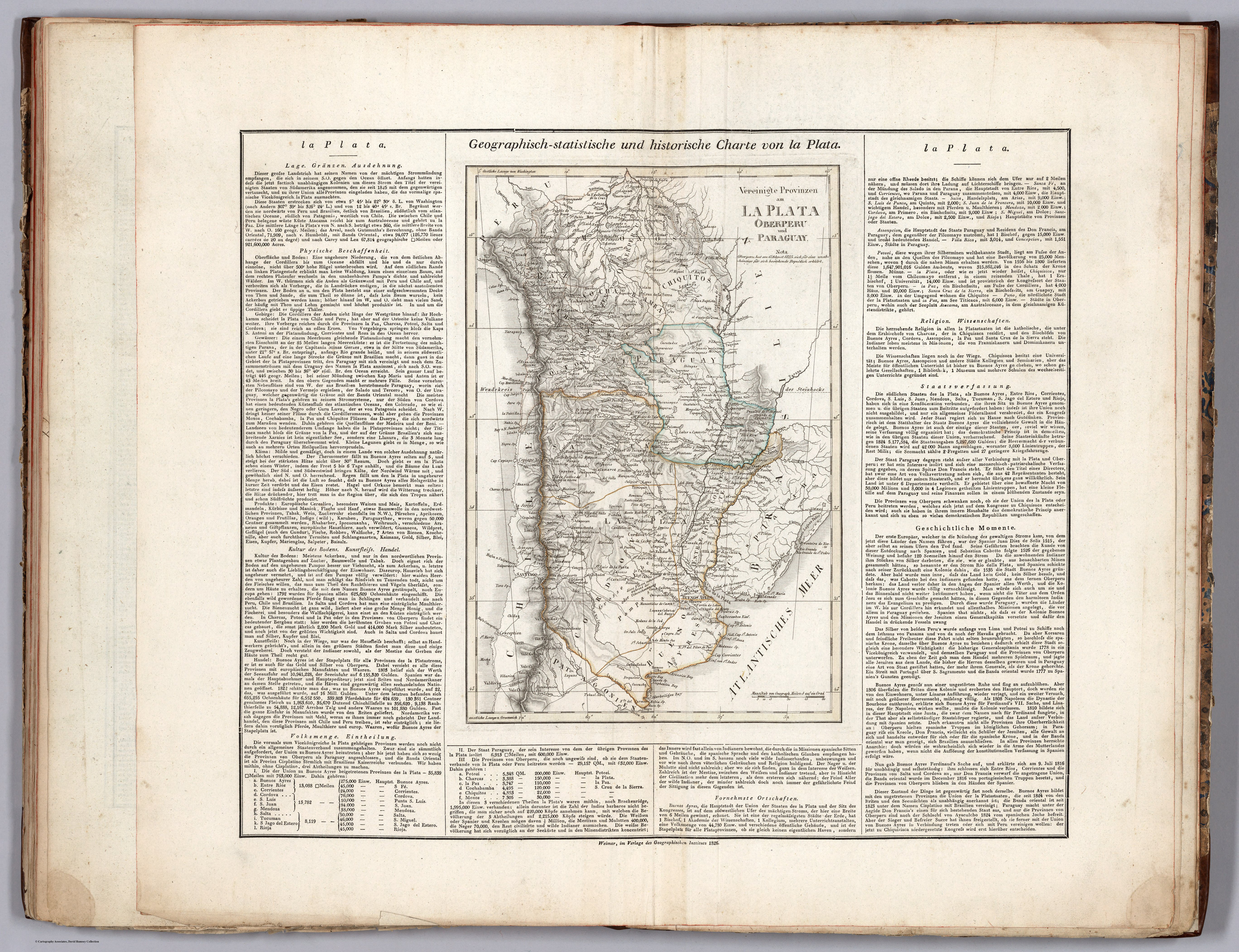
Mapa 1826

Vereinigte Provinzen am LA PLATA Oberperu und Paraguay

  • WEILAND, CARL FERDINAND, ET AL.

Publicado: 1829

  • Descargar Imágen
  • Descargar Imágen
Mapa 1826

Vereinigte Provinzen am LA PLATA Oberperu und Paraguay

  • WEILAND, CARL FERDINAND, ET AL.

Publicado: 1829

  • Descargar Imágen

Pueblos

  • COLOTAS
  • OJOTAES
  • TEQUETS
  • CHORARACAS
  • CUCUTADES
  • ZAMUCO
  • EMBOCARAOANAS
  • FURUNES
  • JONOCOTES
  • AGUSE
  • PILDORIS
  • IBITAYAS
  • PALALIS
  • TOPAYES
  • GUATUTAS
  • POREREGUANOS
  • GURRUCANES
  • YUCUNAMPAS
  • NAPARUS
  • PALOMOS
  • MUSTAUAS
  • PALCIPAS
  • AMOGEMBAS
  • CALAGAES

Citas

Weiland, Carl Ferdinand, and Georg Hassel. Geographisch-statistische und historische Charte von la Plata. Map. Weimar: Geographischen Instituts, 1826. Accessed April 20, 2023. https://www.davidrumsey.com/luna/servlet/detail/RUMSEY~8~1~297502~90069125:La-Plata-?sort=pub_list_no_initialsort%2Cpub_date%2Cpub_list_no%2Cseries_no#.
  • Descargar Imágen

Artículos Relacionados

CAMPECHE

CAMPECHE

Mapa 2015
SCHEMATIC MAP OF DISTRIBUTION OF MAYA-SPEAKING INDIANS (From Morley, 1956, pl.7)

SCHEMATIC MAP OF DISTRIBUTION OF MAYA-SPEAKING INDIANS (From Morley, 1956, pl.7)

Mapa
Carte de la Guïane françoise ou du gouvernement de Caïenne depuis le Cap de Nord jusqu'àla rivière de Maroni inclusivement.

Carte de la Guïane françoise ou du gouvernement de Caïenne depuis le Cap de Nord jusqu'àla rivière de Maroni inclusivement.

Mapa 1729
Carte nouvelle de la France Equinoctiale faite et présentée à sa Majesté par le SieurLe Febure de la Barre son Lieutenant Généralen ces pays au mois de septembre 1665

Carte nouvelle de la France Equinoctiale faite et présentée à sa Majesté par le SieurLe Febure de la Barre son Lieutenant Généralen ces pays au mois de septembre 1665

Mapa 1665
Eclipse Solar

Eclipse Solar

Obra de Arte
TERRITORIO DEL SEÑORÍO AYMARA DE LOS QARAQARA EN EL SIGLO XVI

TERRITORIO DEL SEÑORÍO AYMARA DE LOS QARAQARA EN EL SIGLO XVI

Mapa 1530
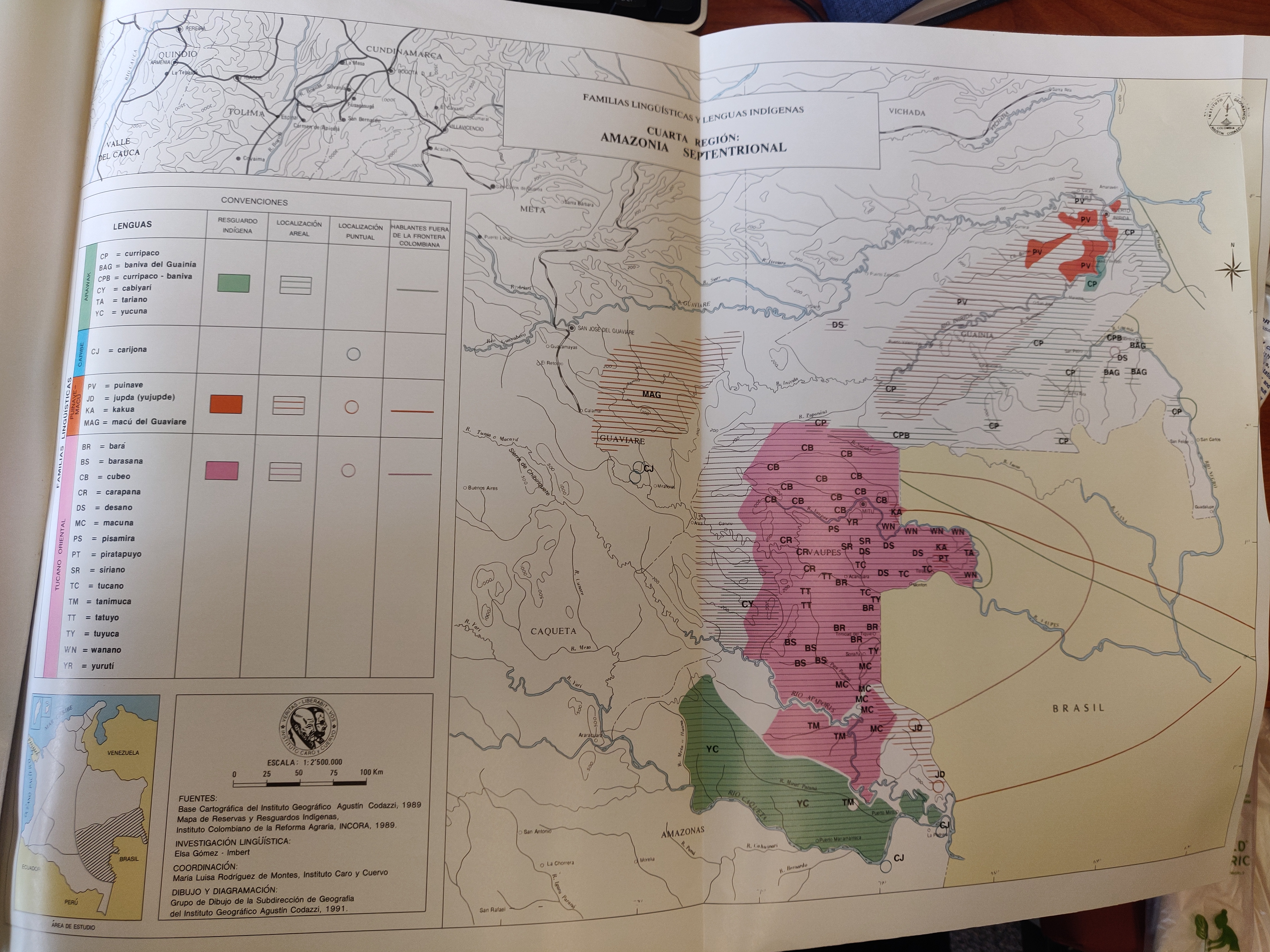
Mapa VI.1 Familias lingüísticas en el área de Orinoquía

Mapa VI.1 Familias lingüísticas en el área de Orinoquía

Mapa 2009
EL TERRITORIO AYOREO EN EL MAPA DE PARAGUAY HOY

EL TERRITORIO AYOREO EN EL MAPA DE PARAGUAY HOY

Mapa 2010

Despojos en las Américas

Un Proyecto de

University of Pennsylvania

Copyright 2024

Con el apoyo de

Mellon Foundation

Diseño y Desarrollo del Sitio

Element 84

Créditos Artísticos

Weiland, Carl Ferdinand, and Georg Hassel. Geographisch-statistische und historische Charte von la Plata. Map. Weimar: Geographischen Instituts, 1826. Accessed April 20, 2023. https://www.davidrumsey.com/luna/servlet/detail/RUMSEY~8~1~297502~90069125:La-Plata-?sort=pub_list_no_initialsort%2Cpub_date%2Cpub_list_no%2Cseries_no#.
Páginas del Sitio

  • Inicio
  • Explorar
  • Autores
  • Sobre
  • Arte
  • Cuerpos
  • Planes de Estudio
  • Herencia Cultural
  • Mapas
  • Territorios