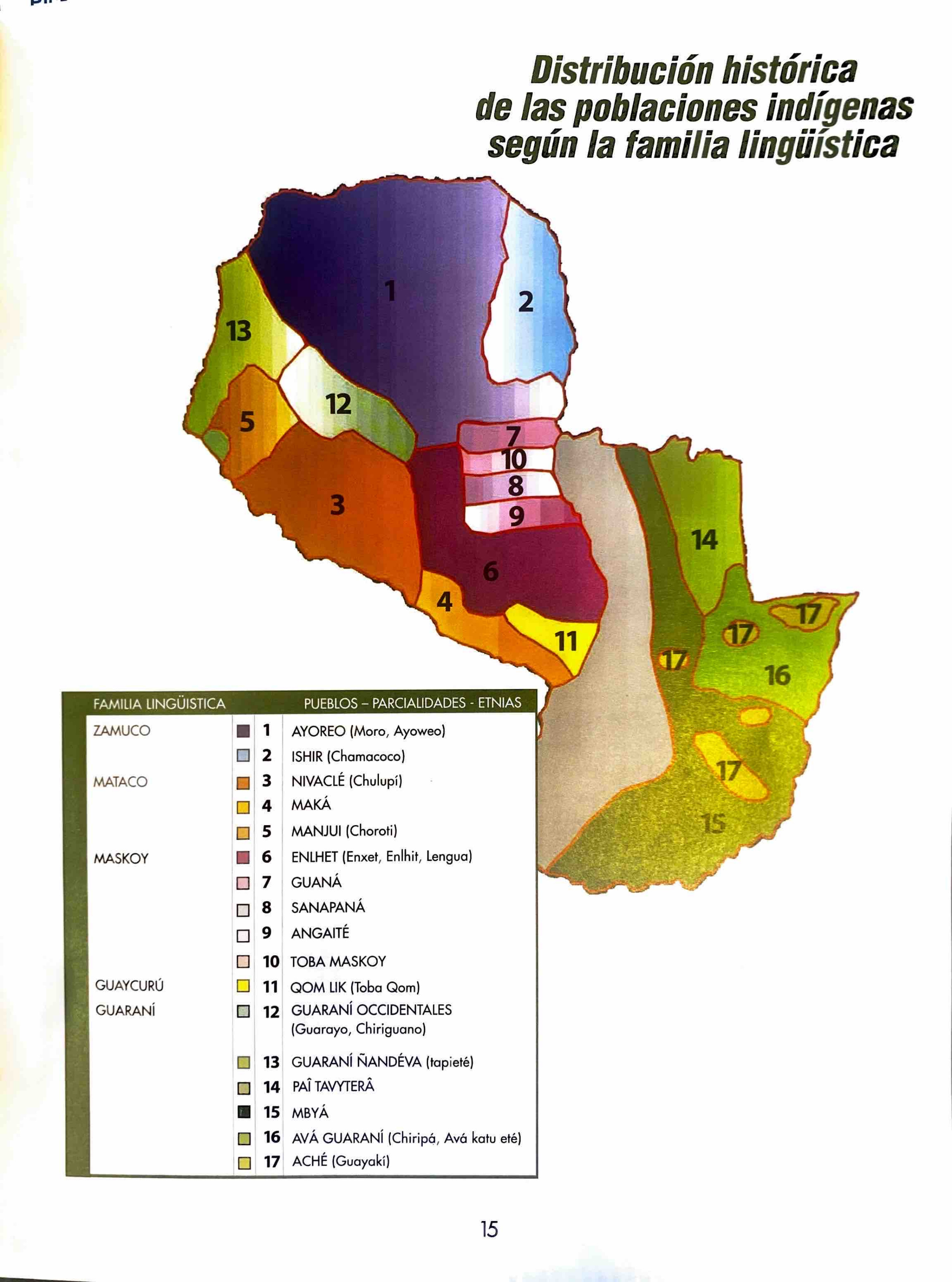
Dispossesions in the Americas

Dispossesions in the Americas

  • Inicio
  • Explorar
  • Autores
  • Sobre
  • Arte
  • Cuerpos
  • Planes de Estudio
  • Herencia Cultural
  • Mapas
  • Territorios
Volver a Explorar

Leyendo en Inglés

Mapa 1490

Distribución histórica de las poblaciones indígenas según la familia lingüística

  • ZANARDINI, JOSE, ET AL.

Publicado: 2001

  • Descargar Imágen
  • Descargar Imágen
Mapa 1490

Distribución histórica de las poblaciones indígenas según la familia lingüística

  • ZANARDINI, JOSE, ET AL.

Publicado: 2001

  • Descargar Imágen

Pueblos

  • AYOREO
  • CHAMACOCO
  • NIVACLE
  • MAKA
  • CHOROTE MANJUY
  • ENLHET NORTE
  • ENXET SUR
  • LENGUA
  • GUANA
  • SANAPANA
  • ANGAITE
  • TOBA MASKOY
  • QOM
  • GUARANI OCCIDENTAL
  • GUARAYO
  • CHIRIGUANO
  • GUARANI NANDEVA
  • TAPIETE
  • PAI TAVYTERA
  • MBYA
  • AVA-GUARANI
  • ACHE

Citas

Zanardini, José, and Walter Biedermann. Los Indígenas Del Paraguay. 2nd ed. Asunción: ITAIPU Binacional, 2006.

  • Descargar Imágen

Artículos Relacionados

CARTE que représente la Partie Méridionale DU BRÉSIL ET DU PEROU;LE CHILI SEPTENTRIONAL;EL LE PARAGUAY;Ce qui fait la Pártie de milieu DE L’AMÉRIQUE MERIDIONALE PAR LE SR. D’ANVILLE À VENISE Par P. Santini 1779. Chez M’.Remondiri.

CARTE que représente la Partie Méridionale DU BRÉSIL ET DU PEROU;LE CHILI SEPTENTRIONAL;EL LE PARAGUAY;Ce qui fait la Pártie de milieu DE L’AMÉRIQUE MERIDIONALE PAR LE SR. D’ANVILLE À VENISE Par P. Santini 1779. Chez M’.Remondiri.

Mapa 1779
Area of Tarascan Speech around 1800

Area of Tarascan Speech around 1800

Mapa 1800
The Tawahka: Most important municipios, 2001

The Tawahka: Most important municipios, 2001

Mapa 2001
Mapa que muestra la zona al este y al sur del río Paraná, desde los 27°00' S. a 37°00' S. y Uruguay

Mapa que muestra la zona al este y al sur del río Paraná, desde los 27°00' S. a 37°00' S. y Uruguay

Mapa 1750
The Spanish and Musketor shore and the bay of Honduras and the islands adjacent

The Spanish and Musketor shore and the bay of Honduras and the islands adjacent

Mapa 1735
Mapa de la ubicación de Pueblo Ranquel

Mapa de la ubicación de Pueblo Ranquel

Mapa 2016
Carte du gouvernement de Cayenne jusqu'à la rivière des Amazones.

Carte du gouvernement de Cayenne jusqu'à la rivière des Amazones.

Mapa 1697
Carte du Chili depuis le sud du Perou jusqu'au Cap Horn ...
     par Mr. Bonne, Ingr. Hydrographe de la Marine.

Carte du Chili depuis le sud du Perou jusqu'au Cap Horn ... par Mr. Bonne, Ingr. Hydrographe de la Marine.

Mapa 1780

Despojos en las Américas

Un Proyecto de

University of Pennsylvania

Copyright 2024

Con el apoyo de

Mellon Foundation

Diseño y Desarrollo del Sitio

Element 84

Créditos Artísticos

Zanardini, José, and Walter Biedermann. Los Indígenas Del Paraguay. 2nd ed. Asunción: ITAIPU Binacional, 2006.

Páginas del Sitio

  • Inicio
  • Explorar
  • Autores
  • Sobre
  • Arte
  • Cuerpos
  • Planes de Estudio
  • Herencia Cultural
  • Mapas
  • Territorios