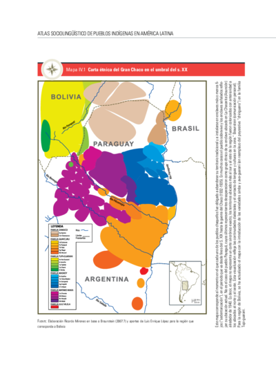
Dispossesions in the Americas

Dispossesions in the Americas

  • Inicio
  • Explorar
  • Autores
  • Sobre
  • Arte
  • Cuerpos
  • Planes de Estudio
  • Herencia Cultural
  • Mapas
  • Territorios
Volver a Explorar

Leyendo en Inglés

Mapa 2009

Pueblos Indígenas en Paraguay

  • VALDIVIA, FREDY

Publicado: 2009

  • Descargar Imágen
  • Descargar Imágen
Mapa 2009

Pueblos Indígenas en Paraguay

  • VALDIVIA, FREDY

Publicado: 2009

  • Descargar Imágen

Pueblos

  • ACHE
  • ANGAITE
  • AVA-GUARANI
  • AYOREO
  • CHAMACOCOS
  • CHOROTE
  • ENLHET NORTE
  • ENXET SUR
  • GUANA
  • GUARANI NANDEVA
  • GUARANI OCCIDENTAL
  • MAKA
  • MBYA
  • NIVACLE
  • PAI TAVYTERA
  • SANAPANA
  • QOM
  • TOBA-ENENLHET
  • TOMARAHO

Citas

Valdivia, Fredy. "Pueblos Indígenas en Paraguay." Map. In Atlas Sociolingüístico de Pueblos Indígenas en América Latina, by Ministerio de Asuntos Exteriores y de Cooperación and UNICEF, 175. Vol. 1. Cochabamba, Bolivia: FUNPROEIB Andes, 2009. Accessed April 9, 2023. https://iwgia.org/es/recursos/publicaciones/317-libros/4493-atlas-socioling%C3%BC%C3%ADstico-de-pueblos-ind%C3%ADgenas-en-am%C3%A9rica-latina-1.html.

  • Descargar Imágen

Artículos Relacionados

Resguardos indígenas en el Departamento de la Guajira

Resguardos indígenas en el Departamento de la Guajira

Mapa
Location of three ethno-linguistic groups in the highlands of Guatemala in which joint InHerit-Riecken community-participant mapping took place. Adapted from http://d-maps. com/carte.php?num_car=1717&lang=en)

Location of three ethno-linguistic groups in the highlands of Guatemala in which joint InHerit-Riecken community-participant mapping took place. Adapted from http://d-maps. com/carte.php?num_car=1717&lang=en)

Mapa 2000
DIE EHEMALIGE VERBREITUNG und die MUTHMASSLICHEN WANDERUNGEN der TUPIS. Die jetzigen HAUPT-SPRACHENGRUPPEN.

DIE EHEMALIGE VERBREITUNG und die MUTHMASSLICHEN WANDERUNGEN der TUPIS. Die jetzigen HAUPT-SPRACHENGRUPPEN.

Mapa 1875
Carte de la Guyane françoise depuis le cap de Nord jusqu'à la R. de Maroni, par le S.r D anville

Carte de la Guyane françoise depuis le cap de Nord jusqu'à la R. de Maroni, par le S.r D anville

Mapa 1729
Haec pars Peruvianae, regiones Chicam & Chile[nsem]
     complectitur, & Regionem

Haec pars Peruvianae, regiones Chicam & Chile[nsem] complectitur, & Regionem

Mapa 1551
BRAZIL BOLIVIA & PERU

BRAZIL BOLIVIA & PERU

Mapa 1830
"Territorio Indígena Cabécar de China Kicha"

"Territorio Indígena Cabécar de China Kicha"

Mapa 2010
(séro)TROPICAL(e)

(séro)TROPICAL(e)

Obra de Arte

Despojos en las Américas

Un Proyecto de

University of Pennsylvania

Copyright 2024

Con el apoyo de

Mellon Foundation

Diseño y Desarrollo del Sitio

Element 84

Créditos Artísticos

Valdivia, Fredy. “Pueblos Indígenas en Paraguay.” Map. In Atlas Sociolingüístico de Pueblos Indígenas en América Latina, by Ministerio de Asuntos Exteriores y de Cooperación and UNICEF, 175. Vol. 1. Cochabamba, Bolivia: FUNPROEIB Andes, 2009. Accessed April 9, 2023. https://iwgia.org/es/recursos/publicaciones/317-libros/4493-atlas-socioling%C3%BC%C3%ADstico-de-pueblos-ind%C3%ADgenas-en-am%C3%A9rica-latina-1.html.

Páginas del Sitio

  • Inicio
  • Explorar
  • Autores
  • Sobre
  • Arte
  • Cuerpos
  • Planes de Estudio
  • Herencia Cultural
  • Mapas
  • Territorios